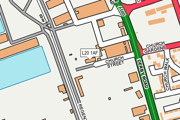
L20 1AF is located in the Linacre electoral ward, within the metropolitan district of Sefton and the English Parliamentary constituency of Bootle. The Sub Integrated Care Board (ICB) Location is NHS Cheshire and Merseyside ICB - 01T and the police force is Merseyside. This postcode has been in use since January 1993.


GetTheData
Source: OS OpenMap – Local (Ordnance Survey)
Source: OS VectorMap District (Ordnance Survey)
Licence: Open Government Licence (requires attribution)
| Easting | 333439 |
| Northing | 395117 |
| Latitude | 53.448593 |
| Longitude | -3.003685 |
GetTheData
Source: Open Postcode Geo
Licence: Open Government Licence
| Country | England |
| Postcode District | L20 |
➜ See where L20 is on a map ➜ Where is Bootle? | |
GetTheData
Source: Land Registry Price Paid Data
Licence: Open Government Licence
Elevation or altitude of L20 1AF as distance above sea level:
| Metres | Feet | |
|---|---|---|
| Elevation | 10m | 33ft |
Elevation is measured from the approximate centre of the postcode, to the nearest point on an OS contour line from OS Terrain 50, which has contour spacing of ten vertical metres.
➜ How high above sea level am I? Find the elevation of your current position using your device's GPS.
GetTheData
Source: Open Postcode Elevation
Licence: Open Government Licence
| Ward | Linacre |
| Constituency | Bootle |
GetTheData
Source: ONS Postcode Database
Licence: Open Government Licence
| Strand Road (Rimrose Road) | Bootle | 233m |
| Atlantic Road (Rimrose Road) | Bootle | 283m |
| Church Gardens (Irlam Road) | Bootle | 324m |
| Grimshaw Street (Derby Road) | Bootle | 331m |
| Strand Road (Irlam Road) | Bootle | 337m |
| Bootle Oriel Road Station | 0.6km |
| Bootle New Strand Station | 0.8km |
| Bank Hall Station | 1.6km |
GetTheData
Source: NaPTAN
Licence: Open Government Licence
GetTheData
Source: ONS Postcode Database
Licence: Open Government Licence


➜ Get more ratings from the Food Standards Agency
GetTheData
Source: Food Standards Agency
Licence: FSA terms & conditions
| Last Collection | |||
|---|---|---|---|
| Location | Mon-Fri | Sat | Distance |
| Bootle New Strand Post Office | 18:00 | 12:00 | 872m |
| Litherland Road | 17:15 | 12:00 | 1,171m |
| Boundary Street | 16:15 | 12:00 | 1,293m |
GetTheData
Source: Dracos
Licence: Creative Commons Attribution-ShareAlike
The below table lists the International Territorial Level (ITL) codes (formerly Nomenclature of Territorial Units for Statistics (NUTS) codes) and Local Administrative Units (LAU) codes for L20 1AF:
| ITL 1 Code | Name |
|---|---|
| TLD | North West (England) |
| ITL 2 Code | Name |
| TLD7 | Merseyside |
| ITL 3 Code | Name |
| TLD73 | Sefton |
| LAU 1 Code | Name |
| E08000014 | Sefton |
GetTheData
Source: ONS Postcode Directory
Licence: Open Government Licence
The below table lists the Census Output Area (OA), Lower Layer Super Output Area (LSOA), and Middle Layer Super Output Area (MSOA) for L20 1AF:
| Code | Name | |
|---|---|---|
| OA | E00035520 | |
| LSOA | E01007009 | Sefton 037D |
| MSOA | E02001465 | Sefton 037 |
GetTheData
Source: ONS Postcode Directory
Licence: Open Government Licence
| L20 1AH | Strand Road | 164m |
| L20 8NB | Pleasant View | 323m |
| L20 8NA | Pleasant Street | 344m |
| L20 4YG | St Marys Close | 371m |
| L20 4AH | Irlam Road | 388m |
| L20 4EA | Irlam Road | 406m |
| L20 4AP | Waverley Street | 421m |
| L20 4BB | Strand Road | 457m |
| L20 4BG | Strand Road | 458m |
| L20 8QU | Canal Street | 463m |
GetTheData
Source: Open Postcode Geo; Land Registry Price Paid Data
Licence: Open Government Licence