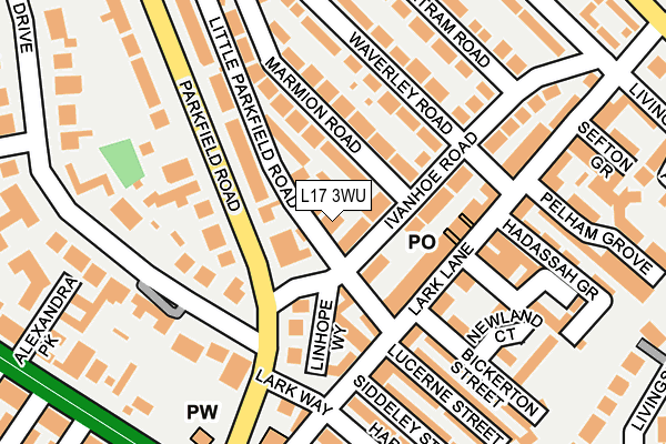
L17 3WU is located in the Sefton Park electoral ward, within the metropolitan district of Liverpool and the English Parliamentary constituency of Liverpool, Riverside. The Sub Integrated Care Board (ICB) Location is NHS Cheshire and Merseyside ICB - 99A and the police force is Merseyside. This postcode has been in use since March 2014.


GetTheData
Source: OS OpenMap – Local (Ordnance Survey)
Source: OS VectorMap District (Ordnance Survey)
Licence: Open Government Licence (requires attribution)
| Easting | 337056 |
| Northing | 387581 |
| Latitude | 53.381310 |
| Longitude | -2.947724 |
GetTheData
Source: Open Postcode Geo
Licence: Open Government Licence
| Country | England |
| Postcode District | L17 |
➜ See where L17 is on a map ➜ Where is Liverpool? | |
GetTheData
Source: Land Registry Price Paid Data
Licence: Open Government Licence
Elevation or altitude of L17 3WU as distance above sea level:
| Metres | Feet | |
|---|---|---|
| Elevation | 30m | 98ft |
Elevation is measured from the approximate centre of the postcode, to the nearest point on an OS contour line from OS Terrain 50, which has contour spacing of ten vertical metres.
➜ How high above sea level am I? Find the elevation of your current position using your device's GPS.
GetTheData
Source: Open Postcode Elevation
Licence: Open Government Licence
| Ward | Sefton Park |
| Constituency | Liverpool, Riverside |
GetTheData
Source: ONS Postcode Database
Licence: Open Government Licence
| Ivanhoe Road (Parkfield Road) | Sefton Park | 83m |
| Alexandra Drive (Parkfield Road) | Sefton Park | 89m |
| Lark Lane (Lark Way) | Sefton Park | 149m |
| Parkfield Road (Lark Way) | Sefton Park | 157m |
| Allington Street (Aigburth Road) | Dingle | 252m |
| St Michaels Station | 0.7km |
| Brunswick Station | 1.9km |
| Mossley Hill Station | 2.2km |
GetTheData
Source: NaPTAN
Licence: Open Government Licence
GetTheData
Source: ONS Postcode Database
Licence: Open Government Licence


➜ Get more ratings from the Food Standards Agency
GetTheData
Source: Food Standards Agency
Licence: FSA terms & conditions
| Last Collection | |||
|---|---|---|---|
| Location | Mon-Fri | Sat | Distance |
| L17 Ldo/Lt Parkfield | 17:30 | 12:00 | 16m |
| Lark Lane Post Office | 17:30 | 12:00 | 133m |
| Ivanhoe Road | 17:30 | 12:00 | 275m |
GetTheData
Source: Dracos
Licence: Creative Commons Attribution-ShareAlike
The below table lists the International Territorial Level (ITL) codes (formerly Nomenclature of Territorial Units for Statistics (NUTS) codes) and Local Administrative Units (LAU) codes for L17 3WU:
| ITL 1 Code | Name |
|---|---|
| TLD | North West (England) |
| ITL 2 Code | Name |
| TLD7 | Merseyside |
| ITL 3 Code | Name |
| TLD72 | Liverpool |
| LAU 1 Code | Name |
| E08000012 | Liverpool |
GetTheData
Source: ONS Postcode Directory
Licence: Open Government Licence
The below table lists the Census Output Area (OA), Lower Layer Super Output Area (LSOA), and Middle Layer Super Output Area (MSOA) for L17 3WU:
| Code | Name | |
|---|---|---|
| OA | E00033034 | |
| LSOA | E01006522 | Liverpool 048A |
| MSOA | E02001394 | Liverpool 048 |
GetTheData
Source: ONS Postcode Directory
Licence: Open Government Licence
| L17 8XQ | Ivanhoe Road | 35m |
| L17 8BA | Ivanhoe Road | 47m |
| L17 8UD | Little Parkfield Road | 47m |
| L17 8XF | Ivanhoe Road | 57m |
| L17 8TX | Marmion Road | 76m |
| L17 8UQ | Parkfield Road | 86m |
| L17 8TT | Marmion Road | 88m |
| L17 8UW | Lark Lane | 95m |
| L17 8SW | Linhope Way | 106m |
| L17 8XG | Ivanhoe Road | 116m |
GetTheData
Source: Open Postcode Geo; Land Registry Price Paid Data
Licence: Open Government Licence