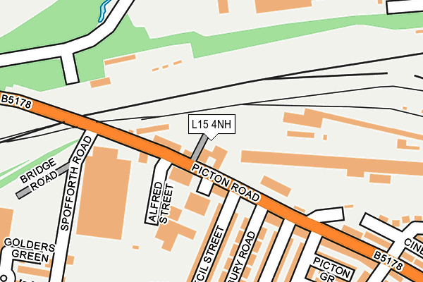
L15 4NH is located in the Smithdown electoral ward, within the metropolitan district of Liverpool and the English Parliamentary constituency of Liverpool, Wavertree. The Sub Integrated Care Board (ICB) Location is NHS Cheshire and Merseyside ICB - 99A and the police force is Merseyside. This postcode has been in use since August 1993.


GetTheData
Source: OS OpenMap – Local (Ordnance Survey)
Source: OS VectorMap District (Ordnance Survey)
Licence: Open Government Licence (requires attribution)
| Easting | 337800 |
| Northing | 389981 |
| Latitude | 53.402968 |
| Longitude | -2.937015 |
GetTheData
Source: Open Postcode Geo
Licence: Open Government Licence
| Country | England |
| Postcode District | L15 |
➜ See where L15 is on a map ➜ Where is Liverpool? | |
GetTheData
Source: Land Registry Price Paid Data
Licence: Open Government Licence
Elevation or altitude of L15 4NH as distance above sea level:
| Metres | Feet | |
|---|---|---|
| Elevation | 50m | 164ft |
Elevation is measured from the approximate centre of the postcode, to the nearest point on an OS contour line from OS Terrain 50, which has contour spacing of ten vertical metres.
➜ How high above sea level am I? Find the elevation of your current position using your device's GPS.
GetTheData
Source: Open Postcode Elevation
Licence: Open Government Licence
| Ward | Smithdown |
| Constituency | Liverpool, Wavertree |
GetTheData
Source: ONS Postcode Database
Licence: Open Government Licence
| Cecil Street (Picton Road) | Wavertree | 70m |
| Cecil Street (Picton Road) | Wavertree | 88m |
| Kempton Road (Picton Road) | Wavertree | 230m |
| Wavertree Technology Park (Wavertree Boulevard) | Wavertree Technology Park | 301m |
| Ashfield (Picton Road) | Wavertree | 337m |
| Edge Hill Station | 0.6km |
| Wavertree Technology Park Station | 1km |
| Liverpool Lime Street Station | 2.7km |
GetTheData
Source: NaPTAN
Licence: Open Government Licence
GetTheData
Source: ONS Postcode Database
Licence: Open Government Licence


➜ Get more ratings from the Food Standards Agency
GetTheData
Source: Food Standards Agency
Licence: FSA terms & conditions
| Last Collection | |||
|---|---|---|---|
| Location | Mon-Fri | Sat | Distance |
| Picton Road | 16:00 | 12:00 | 277m |
| Cardigan Street | 16:00 | 12:00 | 294m |
| Plumer Street | 16:15 | 12:00 | 638m |
GetTheData
Source: Dracos
Licence: Creative Commons Attribution-ShareAlike
The below table lists the International Territorial Level (ITL) codes (formerly Nomenclature of Territorial Units for Statistics (NUTS) codes) and Local Administrative Units (LAU) codes for L15 4NH:
| ITL 1 Code | Name |
|---|---|
| TLD | North West (England) |
| ITL 2 Code | Name |
| TLD7 | Merseyside |
| ITL 3 Code | Name |
| TLD72 | Liverpool |
| LAU 1 Code | Name |
| E08000012 | Liverpool |
GetTheData
Source: ONS Postcode Directory
Licence: Open Government Licence
The below table lists the Census Output Area (OA), Lower Layer Super Output Area (LSOA), and Middle Layer Super Output Area (MSOA) for L15 4NH:
| Code | Name | |
|---|---|---|
| OA | E00034105 | |
| LSOA | E01006720 | Liverpool 035A |
| MSOA | E02001381 | Liverpool 035 |
GetTheData
Source: ONS Postcode Directory
Licence: Open Government Licence
| L15 1HR | Cecil Street | 174m |
| L15 1HP | Cecil Street | 186m |
| L15 1HN | Salisbury Road | 206m |
| L15 4LH | Picton Road | 209m |
| L15 1HQ | Alderson Road | 234m |
| L15 1HF | Kempton Road | 243m |
| L15 1HL | Picton Grove | 248m |
| L15 1HJ | Pengwern Grove | 264m |
| L15 4LD | Picton Road | 265m |
| L15 1HE | Kempton Road | 269m |
GetTheData
Source: Open Postcode Geo; Land Registry Price Paid Data
Licence: Open Government Licence