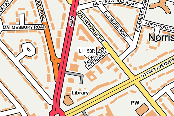
L11 5BR is located in the Norris Green electoral ward, within the metropolitan district of Liverpool and the English Parliamentary constituency of Liverpool, Walton. The Sub Integrated Care Board (ICB) Location is NHS Cheshire and Merseyside ICB - 99A and the police force is Merseyside. This postcode has been in use since March 1983.


GetTheData
Source: OS OpenMap – Local (Ordnance Survey)
Source: OS VectorMap District (Ordnance Survey)
Licence: Open Government Licence (requires attribution)
| Easting | 338296 |
| Northing | 394547 |
| Latitude | 53.444062 |
| Longitude | -2.930451 |
GetTheData
Source: Open Postcode Geo
Licence: Open Government Licence
| Country | England |
| Postcode District | L11 |
➜ See where L11 is on a map ➜ Where is Liverpool? | |
GetTheData
Source: Land Registry Price Paid Data
Licence: Open Government Licence
Elevation or altitude of L11 5BR as distance above sea level:
| Metres | Feet | |
|---|---|---|
| Elevation | 30m | 98ft |
Elevation is measured from the approximate centre of the postcode, to the nearest point on an OS contour line from OS Terrain 50, which has contour spacing of ten vertical metres.
➜ How high above sea level am I? Find the elevation of your current position using your device's GPS.
GetTheData
Source: Open Postcode Elevation
Licence: Open Government Licence
| Ward | Norris Green |
| Constituency | Liverpool, Walton |
GetTheData
Source: ONS Postcode Database
Licence: Open Government Licence
| Strawberry Road (Townsend Avenue) | Walton | 124m |
| Ta Centre (Townsend Avenue) | Norris Green | 133m |
| Utting Avenue East (Townsend Avenue) | Norris Green | 169m |
| Scarisbrick Road (Townsend Avenue) | Walton | 169m |
| Lorenzo Drive (Utting Avenue East) | Norris Green | 173m |
| Rice Lane Station | 2.6km |
| Walton (Merseyside) Station | 2.7km |
| Fazakerley Station | 2.8km |
GetTheData
Source: NaPTAN
Licence: Open Government Licence
GetTheData
Source: ONS Postcode Database
Licence: Open Government Licence


➜ Get more ratings from the Food Standards Agency
GetTheData
Source: Food Standards Agency
Licence: FSA terms & conditions
| Last Collection | |||
|---|---|---|---|
| Location | Mon-Fri | Sat | Distance |
| Mill Bank | 17:15 | 12:00 | 1,984m |
| Cavendish Drive | 16:00 | 12:00 | 2,260m |
| Town Row Delivery Office | 17:30 | 12:00 | 2,349m |
GetTheData
Source: Dracos
Licence: Creative Commons Attribution-ShareAlike
The below table lists the International Territorial Level (ITL) codes (formerly Nomenclature of Territorial Units for Statistics (NUTS) codes) and Local Administrative Units (LAU) codes for L11 5BR:
| ITL 1 Code | Name |
|---|---|
| TLD | North West (England) |
| ITL 2 Code | Name |
| TLD7 | Merseyside |
| ITL 3 Code | Name |
| TLD72 | Liverpool |
| LAU 1 Code | Name |
| E08000012 | Liverpool |
GetTheData
Source: ONS Postcode Directory
Licence: Open Government Licence
The below table lists the Census Output Area (OA), Lower Layer Super Output Area (LSOA), and Middle Layer Super Output Area (MSOA) for L11 5BR:
| Code | Name | |
|---|---|---|
| OA | E00034150 | |
| LSOA | E01006730 | Liverpool 011C |
| MSOA | E02001357 | Liverpool 011 |
GetTheData
Source: ONS Postcode Directory
Licence: Open Government Licence
| L11 5BS | Falklands Approach | 43m |
| L11 5AF | Townsend Avenue | 57m |
| L11 5AN | Parthenon Drive | 101m |
| L11 5AA | Utting Avenue East | 106m |
| L11 7DU | Townsend Avenue | 116m |
| L11 5AR | Colmore Road | 137m |
| L11 7AA | Strawberry Road | 144m |
| L11 7AH | Townsend Avenue | 162m |
| L11 5AS | Fairmead Road | 175m |
| L11 1DQ | Utting Avenue East | 179m |
GetTheData
Source: Open Postcode Geo; Land Registry Price Paid Data
Licence: Open Government Licence