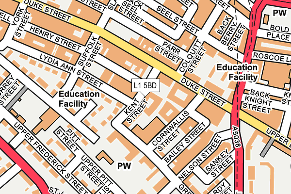
L1 5BD is located in the City Centre South electoral ward, within the metropolitan district of Liverpool and the English Parliamentary constituency of Liverpool, Riverside. The Sub Integrated Care Board (ICB) Location is NHS Cheshire and Merseyside ICB - 99A and the police force is Merseyside. This postcode has been in use since May 2011.


GetTheData
Source: OS OpenMap – Local (Ordnance Survey)
Source: OS VectorMap District (Ordnance Survey)
Licence: Open Government Licence (requires attribution)
| Easting | 334994 |
| Northing | 389714 |
| Latitude | 53.400230 |
| Longitude | -2.979158 |
GetTheData
Source: Open Postcode Geo
Licence: Open Government Licence
| Country | England |
| Postcode District | L1 |
➜ See where L1 is on a map ➜ Where is Liverpool? | |
GetTheData
Source: Land Registry Price Paid Data
Licence: Open Government Licence
Elevation or altitude of L1 5BD as distance above sea level:
| Metres | Feet | |
|---|---|---|
| Elevation | 20m | 66ft |
Elevation is measured from the approximate centre of the postcode, to the nearest point on an OS contour line from OS Terrain 50, which has contour spacing of ten vertical metres.
➜ How high above sea level am I? Find the elevation of your current position using your device's GPS.
GetTheData
Source: Open Postcode Elevation
Licence: Open Government Licence
| Ward | City Centre South |
| Constituency | Liverpool, Riverside |
GetTheData
Source: ONS Postcode Database
Licence: Open Government Licence
| Colquitt Street (Duke Street) | Liverpool | 84m |
| Colquitt Street (Duke Street) | Liverpool | 86m |
| Suffolk Street (Duke Street) | Liverpool | 218m |
| Sankey Street (Great George Street) | Liverpool | 225m |
| Slater Street (Duke Street) | Liverpool | 243m |
| Liverpool Central Station | 0.5km |
| Liverpool Lime Street Station | 0.8km |
| Liverpool Lime Street Low Level Station | 0.9km |
GetTheData
Source: NaPTAN
Licence: Open Government Licence
GetTheData
Source: ONS Postcode Database
Licence: Open Government Licence


➜ Get more ratings from the Food Standards Agency
GetTheData
Source: Food Standards Agency
Licence: FSA terms & conditions
| Last Collection | |||
|---|---|---|---|
| Location | Mon-Fri | Sat | Distance |
| Duke Street | 18:15 | 12:00 | 123m |
| St Lukes Church | 18:00 | 12:00 | 277m |
| St James Street | 18:15 | 12:00 | 336m |
GetTheData
Source: Dracos
Licence: Creative Commons Attribution-ShareAlike
The below table lists the International Territorial Level (ITL) codes (formerly Nomenclature of Territorial Units for Statistics (NUTS) codes) and Local Administrative Units (LAU) codes for L1 5BD:
| ITL 1 Code | Name |
|---|---|
| TLD | North West (England) |
| ITL 2 Code | Name |
| TLD7 | Merseyside |
| ITL 3 Code | Name |
| TLD72 | Liverpool |
| LAU 1 Code | Name |
| E08000012 | Liverpool |
GetTheData
Source: ONS Postcode Directory
Licence: Open Government Licence
The below table lists the Census Output Area (OA), Lower Layer Super Output Area (LSOA), and Middle Layer Super Output Area (MSOA) for L1 5BD:
| Code | Name | |
|---|---|---|
| OA | E00176627 | |
| LSOA | E01033754 | Liverpool 061B |
| MSOA | E02006933 | Liverpool 061 |
GetTheData
Source: ONS Postcode Directory
Licence: Open Government Licence
| L1 5FD | Madison Square | 16m |
| L1 5DA | Kent Street | 29m |
| L1 5BF | Madison Square | 40m |
| L1 5BG | Tradewind Square | 46m |
| L1 5BB | Duke Street | 63m |
| L1 5BU | Henry Street | 77m |
| L1 5EL | Cornwallis Street | 92m |
| L1 4JR | Duke Street | 94m |
| L1 4DA | Colquitt Street | 96m |
| L1 5AG | Duke Street | 98m |
GetTheData
Source: Open Postcode Geo; Land Registry Price Paid Data
Licence: Open Government Licence