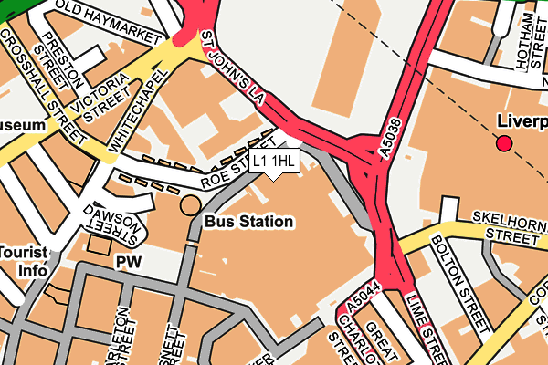
L1 1HL is located in the City Centre North electoral ward, within the metropolitan district of Liverpool and the English Parliamentary constituency of Liverpool, Riverside. The Sub Integrated Care Board (ICB) Location is NHS Cheshire and Merseyside ICB - 99A and the police force is Merseyside. This postcode has been in use since January 1980.


GetTheData
Source: OS OpenMap – Local (Ordnance Survey)
Source: OS VectorMap District (Ordnance Survey)
Licence: Open Government Licence (requires attribution)
| Easting | 334861 |
| Northing | 390511 |
| Latitude | 53.407376 |
| Longitude | -2.981323 |
GetTheData
Source: Open Postcode Geo
Licence: Open Government Licence
| Country | England |
| Postcode District | L1 |
➜ See where L1 is on a map ➜ Where is Liverpool? | |
GetTheData
Source: Land Registry Price Paid Data
Licence: Open Government Licence
Elevation or altitude of L1 1HL as distance above sea level:
| Metres | Feet | |
|---|---|---|
| Elevation | 10m | 33ft |
Elevation is measured from the approximate centre of the postcode, to the nearest point on an OS contour line from OS Terrain 50, which has contour spacing of ten vertical metres.
➜ How high above sea level am I? Find the elevation of your current position using your device's GPS.
GetTheData
Source: Open Postcode Elevation
Licence: Open Government Licence
| Ward | City Centre North |
| Constituency | Liverpool, Riverside |
GetTheData
Source: ONS Postcode Database
Licence: Open Government Licence
| St Johns Garden (St Johns Lane) | Liverpool | 114m |
| Elliot Street | Liverpool | 147m |
| Elliot Street | Liverpool | 148m |
| Whitechapel | Liverpool | 166m |
| St Georges Hall (Lime Street) | Liverpool | 171m |
| Liverpool Lime Street Station | 0.2km |
| Liverpool Lime Street Low Level Station | 0.3km |
| Liverpool Central Station | 0.3km |
GetTheData
Source: NaPTAN
Licence: Open Government Licence
GetTheData
Source: ONS Postcode Database
Licence: Open Government Licence


➜ Get more ratings from the Food Standards Agency
GetTheData
Source: Food Standards Agency
Licence: FSA terms & conditions
| Last Collection | |||
|---|---|---|---|
| Location | Mon-Fri | Sat | Distance |
| Houghton Street | 18:30 | 12:00 | 136m |
| Houghton Street | 18:30 | 142m | |
| Lime Street Station | 17:30 | 12:00 | 208m |
GetTheData
Source: Dracos
Licence: Creative Commons Attribution-ShareAlike
The below table lists the International Territorial Level (ITL) codes (formerly Nomenclature of Territorial Units for Statistics (NUTS) codes) and Local Administrative Units (LAU) codes for L1 1HL:
| ITL 1 Code | Name |
|---|---|
| TLD | North West (England) |
| ITL 2 Code | Name |
| TLD7 | Merseyside |
| ITL 3 Code | Name |
| TLD72 | Liverpool |
| LAU 1 Code | Name |
| E08000012 | Liverpool |
GetTheData
Source: ONS Postcode Directory
Licence: Open Government Licence
The below table lists the Census Output Area (OA), Lower Layer Super Output Area (LSOA), and Middle Layer Super Output Area (MSOA) for L1 1HL:
| Code | Name | |
|---|---|---|
| OA | E00176652 | |
| LSOA | E01033760 | Liverpool 060C |
| MSOA | E02006932 | Liverpool 060 |
GetTheData
Source: ONS Postcode Directory
Licence: Open Government Licence
| L1 1DP | Clayton Square | 182m |
| L1 1RD | Lime Street | 189m |
| L1 1JQ | Lime Street | 194m |
| L1 6DG | Victoria Street | 204m |
| L1 1HU | Great Charlotte Street | 204m |
| L1 6LD | Victoria Street | 208m |
| L1 6ER | Old Haymarket | 215m |
| L1 1QR | Clayton Square Shopping Centre | 217m |
| L1 6DE | Victoria Street | 218m |
| L1 1EF | Richmond Street | 224m |
GetTheData
Source: Open Postcode Geo; Land Registry Price Paid Data
Licence: Open Government Licence