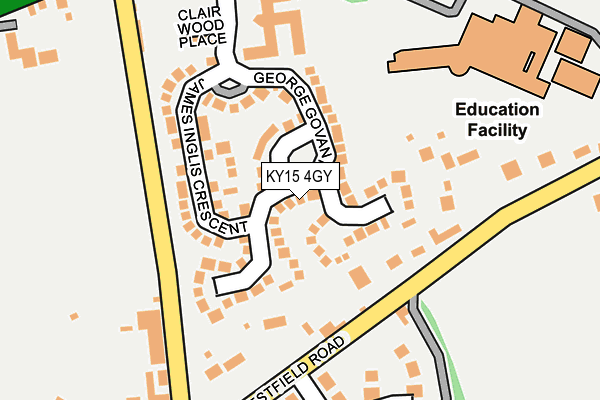
KY15 4GY is located in the Cupar electoral ward, within the council area of Fife and the Scottish Parliamentary constituency of North East Fife. The Community Health Partnership is Glenrothes & North East Fife Community Health Partnership and the police force is Scotland. This postcode has been in use since March 2005.


GetTheData
Source: OS OpenMap – Local (Ordnance Survey)
Source: OS VectorMap District (Ordnance Survey)
Licence: Open Government Licence (requires attribution)
| Easting | 336237 |
| Northing | 714189 |
| Latitude | 56.315794 |
| Longitude | -3.032376 |
GetTheData
Source: Open Postcode Geo
Licence: Open Government Licence
| Country | Scotland |
| Postcode District | KY15 |
➜ See where KY15 is on a map ➜ Where is Cupar? | |
GetTheData
Source: Land Registry Price Paid Data
Licence: Open Government Licence
| Ward | Cupar |
| Constituency | North East Fife |
GetTheData
Source: ONS Postcode Database
Licence: Open Government Licence
| George Govan Road | Cupar | 22m |
| James Inglis Crescent | Cupar | 118m |
| Bell Baxter High School (Carslogie Road) | Cupar | 174m |
| Bell Baxter High School (Carslogie Road) | Cupar | 178m |
| Bell Baxter High School (Carslogie Road) | Cupar | 181m |
| Cupar Station | 1.5km |
| Springfield Station | 2.6km |
GetTheData
Source: NaPTAN
Licence: Open Government Licence
| Percentage of properties with Next Generation Access | 100.0% |
| Percentage of properties with Superfast Broadband | 100.0% |
| Percentage of properties with Ultrafast Broadband | 0.0% |
| Percentage of properties with Full Fibre Broadband | 0.0% |
Superfast Broadband is between 30Mbps and 300Mbps
Ultrafast Broadband is > 300Mbps
| Median download speed | 72.1Mbps |
| Average download speed | 57.4Mbps |
| Maximum download speed | 80.00Mbps |
| Median upload speed | 19.5Mbps |
| Average upload speed | 14.3Mbps |
| Maximum upload speed | 20.00Mbps |
| Percentage of properties unable to receive 2Mbps | 0.0% |
| Percentage of properties unable to receive 5Mbps | 0.0% |
| Percentage of properties unable to receive 10Mbps | 0.0% |
| Percentage of properties unable to receive 30Mbps | 0.0% |
GetTheData
Source: Ofcom
Licence: Ofcom Terms of Use (requires attribution)
Estimated total energy consumption in KY15 4GY by fuel type, 2015.
| Consumption (kWh) | 1,064,052 |
|---|---|
| Meter count | 67 |
| Mean (kWh/meter) | 15,881 |
| Median (kWh/meter) | 15,537 |
| Consumption (kWh) | 103,137 |
|---|---|
| Meter count | 27 |
| Mean (kWh/meter) | 3,820 |
| Median (kWh/meter) | 3,578 |
GetTheData
Source: Postcode level gas estimates: 2015 (experimental)
Source: Postcode level electricity estimates: 2015 (experimental)
Licence: Open Government Licence
GetTheData
Source: ONS Postcode Database
Licence: Open Government Licence


➜ Get more ratings from the Food Standards Agency
GetTheData
Source: Food Standards Agency
Licence: FSA terms & conditions
| Last Collection | |||
|---|---|---|---|
| Location | Mon-Fri | Sat | Distance |
| Meadowside | 16:30 | 11:15 | 1,544m |
| Bridgend | 15:00 | 11:50 | 4,067m |
| Bow Of Fife Post Office | 13:00 | 11:30 | 4,380m |
GetTheData
Source: Dracos
Licence: Creative Commons Attribution-ShareAlike
The below table lists the International Territorial Level (ITL) codes (formerly Nomenclature of Territorial Units for Statistics (NUTS) codes) and Local Administrative Units (LAU) codes for KY15 4GY:
| ITL 1 Code | Name |
|---|---|
| TLM | Scotland |
| ITL 2 Code | Name |
| TLM7 | Eastern Scotland |
| ITL 3 Code | Name |
| TLM72 | Clackmannanshire and Fife |
| LAU 1 Code | Name |
| S30000042 | Fife |
GetTheData
Source: ONS Postcode Directory
Licence: Open Government Licence
The below table lists the Census Output Area (OA), Lower Layer Super Output Area (LSOA), and Middle Layer Super Output Area (MSOA) for KY15 4GY:
| Code | Name | |
|---|---|---|
| OA | S00109090 | |
| LSOA | S01009684 | Bow of Fife Tarvit and Balgarvie |
| MSOA | S02001826 | Cupar West and Springfield |
GetTheData
Source: ONS Postcode Directory
Licence: Open Government Licence