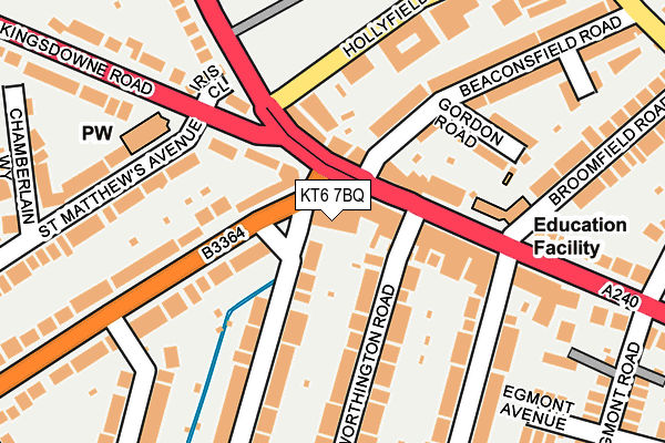
KT6 7BQ is located in the Tolworth electoral ward, within the London borough of Kingston upon Thames and the English Parliamentary constituency of Kingston and Surbiton. The Sub Integrated Care Board (ICB) Location is NHS South West London ICB - 36L and the police force is Metropolitan Police. This postcode has been in use since March 2017.


GetTheData
Source: OS OpenMap – Local (Ordnance Survey)
Source: OS VectorMap District (Ordnance Survey)
Licence: Open Government Licence (requires attribution)
| Easting | 518745 |
| Northing | 166454 |
| Latitude | 51.384719 |
| Longitude | -0.294952 |
GetTheData
Source: Open Postcode Geo
Licence: Open Government Licence
| Country | England |
| Postcode District | KT6 |
➜ See where KT6 is on a map ➜ Where is London? | |
GetTheData
Source: Land Registry Price Paid Data
Licence: Open Government Licence
| Ward | Tolworth |
| Constituency | Kingston And Surbiton |
GetTheData
Source: ONS Postcode Database
Licence: Open Government Licence
| Hollyfield Road (Ewell Road) | Southborough | 111m |
| Surbiton Broomfield Road (Ewell Road) | Southborough | 126m |
| Surbiton Broomfield Road (Ewell Road) | Southborough | 130m |
| Hollyfield Road (Ewell Road) | Southborough | 154m |
| Ditton Road | Southborough | 388m |
| Surbiton Station | 1.1km |
| Tolworth Station | 1.4km |
| Berrylands Station | 1.9km |
GetTheData
Source: NaPTAN
Licence: Open Government Licence
| Percentage of properties with Next Generation Access | 100.0% |
| Percentage of properties with Superfast Broadband | 100.0% |
| Percentage of properties with Ultrafast Broadband | 100.0% |
| Percentage of properties with Full Fibre Broadband | 0.0% |
Superfast Broadband is between 30Mbps and 300Mbps
Ultrafast Broadband is > 300Mbps
| Median download speed | 47.5Mbps |
| Average download speed | 48.6Mbps |
| Maximum download speed | 80.00Mbps |
| Median upload speed | 10.0Mbps |
| Average upload speed | 10.4Mbps |
| Maximum upload speed | 20.00Mbps |
| Percentage of properties unable to receive 2Mbps | 0.0% |
| Percentage of properties unable to receive 5Mbps | 0.0% |
| Percentage of properties unable to receive 10Mbps | 0.0% |
| Percentage of properties unable to receive 30Mbps | 0.0% |
GetTheData
Source: Ofcom
Licence: Ofcom Terms of Use (requires attribution)
GetTheData
Source: ONS Postcode Database
Licence: Open Government Licence


➜ Get more ratings from the Food Standards Agency
GetTheData
Source: Food Standards Agency
Licence: FSA terms & conditions
| Last Collection | |||
|---|---|---|---|
| Location | Mon-Fri | Sat | Distance |
| 284 Ewell Road | 17:30 | 12:15 | 98m |
| Broomfield Road | 17:45 | 12:00 | 358m |
| Southborough | 17:30 | 12:00 | 408m |
GetTheData
Source: Dracos
Licence: Creative Commons Attribution-ShareAlike
| Risk of KT6 7BQ flooding from rivers and sea | Low |
| ➜ KT6 7BQ flood map | |
GetTheData
Source: Open Flood Risk by Postcode
Licence: Open Government Licence
The below table lists the International Territorial Level (ITL) codes (formerly Nomenclature of Territorial Units for Statistics (NUTS) codes) and Local Administrative Units (LAU) codes for KT6 7BQ:
| ITL 1 Code | Name |
|---|---|
| TLI | London |
| ITL 2 Code | Name |
| TLI6 | Outer London - South |
| ITL 3 Code | Name |
| TLI63 | Merton, Kingston upon Thames and Sutton |
| LAU 1 Code | Name |
| E09000021 | Kingston upon Thames |
GetTheData
Source: ONS Postcode Directory
Licence: Open Government Licence
The below table lists the Census Output Area (OA), Lower Layer Super Output Area (LSOA), and Middle Layer Super Output Area (MSOA) for KT6 7BQ:
| Code | Name | |
|---|---|---|
| OA | E00015084 | |
| LSOA | E01002996 | Kingston upon Thames 016B |
| MSOA | E02000613 | Kingston upon Thames 016 |
GetTheData
Source: ONS Postcode Directory
Licence: Open Government Licence
| KT6 7AG | Ewell Road | 42m |
| KT6 7AA | Ewell Road | 72m |
| KT6 6LA | Kingsdowne Road | 92m |
| KT6 7AB | Ewell Road | 101m |
| KT6 7AQ | Ewell Road | 116m |
| KT5 9AJ | Hollyfield Road | 133m |
| KT6 6QZ | Ditton Road | 134m |
| KT6 7TX | Ellerton Road | 145m |
| KT6 6RE | Ditton Road | 146m |
| KT5 9AR | Gordon Road | 148m |
GetTheData
Source: Open Postcode Geo; Land Registry Price Paid Data
Licence: Open Government Licence