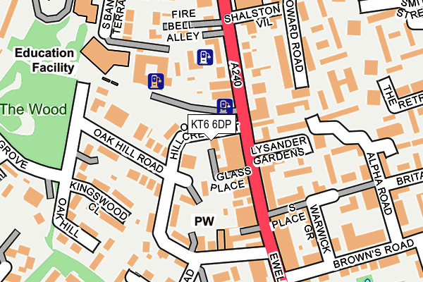
KT6 6DP is located in the Surbiton Hill electoral ward, within the London borough of Kingston upon Thames and the English Parliamentary constituency of Kingston and Surbiton. The Sub Integrated Care Board (ICB) Location is NHS South West London ICB - 36L and the police force is Metropolitan Police. This postcode has been in use since April 2017.


GetTheData
Source: OS OpenMap – Local (Ordnance Survey)
Source: OS VectorMap District (Ordnance Survey)
Licence: Open Government Licence (requires attribution)
| Easting | 518471 |
| Northing | 167038 |
| Latitude | 51.390025 |
| Longitude | -0.298693 |
GetTheData
Source: Open Postcode Geo
Licence: Open Government Licence
| Country | England |
| Postcode District | KT6 |
➜ See where KT6 is on a map ➜ Where is Surbiton? | |
GetTheData
Source: Land Registry Price Paid Data
Licence: Open Government Licence
| Ward | Surbiton Hill |
| Constituency | Kingston And Surbiton |
GetTheData
Source: ONS Postcode Database
Licence: Open Government Licence
| Surbiton Health Centre | Surbiton | 71m |
| Surbiton Health Centre (Ewell Road) | Surbiton | 95m |
| Browns Road (Ewell Road) | Surbiton | 181m |
| Browns Road (Ewell Road) | Surbiton | 212m |
| Howard Road (Kt5) | Surbiton | 357m |
| Surbiton Station | 0.5km |
| Berrylands Station | 1.6km |
| Tolworth Station | 2km |
GetTheData
Source: NaPTAN
Licence: Open Government Licence
| Percentage of properties with Next Generation Access | 100.0% |
| Percentage of properties with Superfast Broadband | 100.0% |
| Percentage of properties with Ultrafast Broadband | 0.0% |
| Percentage of properties with Full Fibre Broadband | 0.0% |
Superfast Broadband is between 30Mbps and 300Mbps
Ultrafast Broadband is > 300Mbps
| Percentage of properties unable to receive 2Mbps | 0.0% |
| Percentage of properties unable to receive 5Mbps | 0.0% |
| Percentage of properties unable to receive 10Mbps | 0.0% |
| Percentage of properties unable to receive 30Mbps | 0.0% |
GetTheData
Source: Ofcom
Licence: Ofcom Terms of Use (requires attribution)
GetTheData
Source: ONS Postcode Database
Licence: Open Government Licence


➜ Get more ratings from the Food Standards Agency
GetTheData
Source: Food Standards Agency
Licence: FSA terms & conditions
| Last Collection | |||
|---|---|---|---|
| Location | Mon-Fri | Sat | Distance |
| Surbiton Hill | 17:30 | 12:00 | 80m |
| Oakhill Road | 17:30 | 12:00 | 183m |
| 37 Browns Road | 17:45 | 12:00 | 326m |
GetTheData
Source: Dracos
Licence: Creative Commons Attribution-ShareAlike
The below table lists the International Territorial Level (ITL) codes (formerly Nomenclature of Territorial Units for Statistics (NUTS) codes) and Local Administrative Units (LAU) codes for KT6 6DP:
| ITL 1 Code | Name |
|---|---|
| TLI | London |
| ITL 2 Code | Name |
| TLI6 | Outer London - South |
| ITL 3 Code | Name |
| TLI63 | Merton, Kingston upon Thames and Sutton |
| LAU 1 Code | Name |
| E09000021 | Kingston upon Thames |
GetTheData
Source: ONS Postcode Directory
Licence: Open Government Licence
The below table lists the Census Output Area (OA), Lower Layer Super Output Area (LSOA), and Middle Layer Super Output Area (MSOA) for KT6 6DP:
| Code | Name | |
|---|---|---|
| OA | E00015077 | |
| LSOA | E01002999 | Kingston upon Thames 013E |
| MSOA | E02000610 | Kingston upon Thames 013 |
GetTheData
Source: ONS Postcode Directory
Licence: Open Government Licence
| KT6 6EG | Oakhill Road | 43m |
| KT6 6HA | Ewell Road | 46m |
| KT6 6EQ | Oakhill Crescent | 57m |
| KT6 6EF | Oakhill Road | 69m |
| KT6 6AT | Lysander Gardens | 81m |
| KT6 6EX | Ewell Road | 95m |
| KT6 6AL | Ewell Road | 98m |
| KT6 6AH | Ewell Road | 101m |
| KT6 6EL | Oakhill Road | 106m |
| KT6 6EH | Oakhill Road | 111m |
GetTheData
Source: Open Postcode Geo; Land Registry Price Paid Data
Licence: Open Government Licence