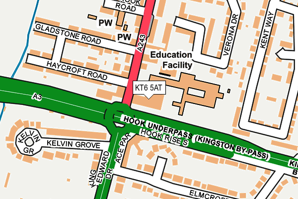
KT6 5AT is located in the Tolworth electoral ward, within the London borough of Kingston upon Thames and the English Parliamentary constituency of Kingston and Surbiton. The Sub Integrated Care Board (ICB) Location is NHS South West London ICB - 36L and the police force is Metropolitan Police. This postcode has been in use since January 1980.


GetTheData
Source: OS OpenMap – Local (Ordnance Survey)
Source: OS VectorMap District (Ordnance Survey)
Licence: Open Government Licence (requires attribution)
| Easting | 518202 |
| Northing | 165409 |
| Latitude | 51.375440 |
| Longitude | -0.303099 |
GetTheData
Source: Open Postcode Geo
Licence: Open Government Licence
| Country | England |
| Postcode District | KT6 |
➜ See where KT6 is on a map ➜ Where is London? | |
GetTheData
Source: Land Registry Price Paid Data
Licence: Open Government Licence
Elevation or altitude of KT6 5AT as distance above sea level:
| Metres | Feet | |
|---|---|---|
| Elevation | 30m | 98ft |
Elevation is measured from the approximate centre of the postcode, to the nearest point on an OS contour line from OS Terrain 50, which has contour spacing of ten vertical metres.
➜ How high above sea level am I? Find the elevation of your current position using your device's GPS.
GetTheData
Source: Open Postcode Elevation
Licence: Open Government Licence
| Ward | Tolworth |
| Constituency | Kingston And Surbiton |
GetTheData
Source: ONS Postcode Database
Licence: Open Government Licence
| Southborough High School (Hook Road) | Hook | 47m |
| Southborough High School (Hook Road) | Hook | 84m |
| Elmcroft Drive | Hook | 228m |
| Elmcroft Drive | Hook | 268m |
| Thornhill Road Hook Road (Hook Road) | Southborough | 386m |
| Chessington North Station | 1.3km |
| Tolworth Station | 1.7km |
| Surbiton Station | 1.9km |
GetTheData
Source: NaPTAN
Licence: Open Government Licence
GetTheData
Source: ONS Postcode Database
Licence: Open Government Licence


➜ Get more ratings from the Food Standards Agency
GetTheData
Source: Food Standards Agency
Licence: FSA terms & conditions
| Last Collection | |||
|---|---|---|---|
| Location | Mon-Fri | Sat | Distance |
| Leatherhead Road | 17:30 | 11:30 | 116m |
| 149 Hook Road | 17:30 | 12:00 | 134m |
| Elmcroft Drive | 16:45 | 11:30 | 152m |
GetTheData
Source: Dracos
Licence: Creative Commons Attribution-ShareAlike
The below table lists the International Territorial Level (ITL) codes (formerly Nomenclature of Territorial Units for Statistics (NUTS) codes) and Local Administrative Units (LAU) codes for KT6 5AT:
| ITL 1 Code | Name |
|---|---|
| TLI | London |
| ITL 2 Code | Name |
| TLI6 | Outer London - South |
| ITL 3 Code | Name |
| TLI63 | Merton, Kingston upon Thames and Sutton |
| LAU 1 Code | Name |
| E09000021 | Kingston upon Thames |
GetTheData
Source: ONS Postcode Directory
Licence: Open Government Licence
The below table lists the Census Output Area (OA), Lower Layer Super Output Area (LSOA), and Middle Layer Super Output Area (MSOA) for KT6 5AT:
| Code | Name | |
|---|---|---|
| OA | E00015122 | |
| LSOA | E01003002 | Kingston upon Thames 016E |
| MSOA | E02000613 | Kingston upon Thames 016 |
GetTheData
Source: ONS Postcode Directory
Licence: Open Government Licence
| KT6 5DE | Hook Rise North | 95m |
| KT9 1DX | Elmcroft Close | 108m |
| KT6 5BZ | Hook Road | 124m |
| KT6 5AR | Hook Road | 128m |
| KT6 5AU | Haycroft Road | 149m |
| KT6 5BD | Verona Drive | 157m |
| KT9 1ET | Elmcroft Drive | 169m |
| KT6 5DD | Gladstone Road | 181m |
| KT9 1DW | King Edward Drive | 181m |
| KT6 5BB | Hook Road | 185m |
GetTheData
Source: Open Postcode Geo; Land Registry Price Paid Data
Licence: Open Government Licence