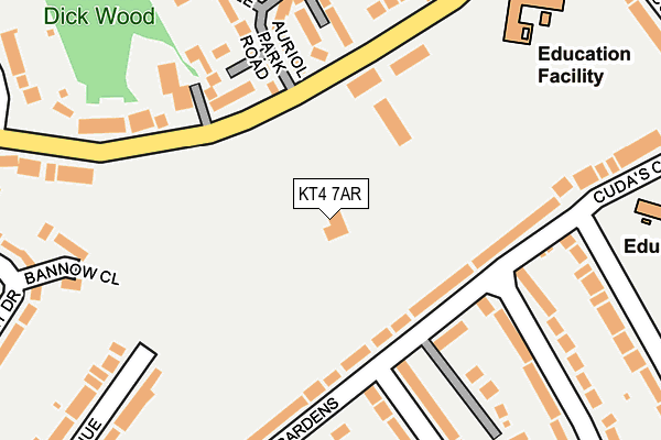
KT4 7AR is located in the Auriol electoral ward, within the local authority district of Epsom and Ewell and the English Parliamentary constituency of Epsom and Ewell. The Sub Integrated Care Board (ICB) Location is NHS Surrey Heartlands ICB - 92A and the police force is Surrey. This postcode has been in use since June 2017.


GetTheData
Source: OS OpenMap – Local (Ordnance Survey)
Source: OS VectorMap District (Ordnance Survey)
Licence: Open Government Licence (requires attribution)
| Easting | 521450 |
| Northing | 164932 |
| Latitude | 51.370468 |
| Longitude | -0.256618 |
GetTheData
Source: Open Postcode Geo
Licence: Open Government Licence
| Country | England |
| Postcode District | KT4 |
➜ See where KT4 is on a map ➜ Where is Worcester Park? | |
GetTheData
Source: Land Registry Price Paid Data
Licence: Open Government Licence
| Ward | Auriol |
| Constituency | Epsom And Ewell |
GetTheData
Source: ONS Postcode Database
Licence: Open Government Licence
| Thorndon Gardens | Stoneleigh | 200m |
| Thorndon Gardens | Stoneleigh | 203m |
| Newbury Gardens | Stoneleigh | 277m |
| Newbury Gardens | Stoneleigh | 280m |
| Cuddington Avenue | Stoneleigh | 360m |
| Stoneleigh Station | 1km |
| Worcester Park Station | 1.4km |
| Malden Manor Station | 1.6km |
GetTheData
Source: NaPTAN
Licence: Open Government Licence
GetTheData
Source: ONS Postcode Database
Licence: Open Government Licence


➜ Get more ratings from the Food Standards Agency
GetTheData
Source: Food Standards Agency
Licence: FSA terms & conditions
| Last Collection | |||
|---|---|---|---|
| Location | Mon-Fri | Sat | Distance |
| Delta Road | 17:30 | 12:00 | 309m |
| Walsingham Gardens | 17:15 | 12:15 | 374m |
| Vale Road Post Office | 17:00 | 12:00 | 467m |
GetTheData
Source: Dracos
Licence: Creative Commons Attribution-ShareAlike
The below table lists the International Territorial Level (ITL) codes (formerly Nomenclature of Territorial Units for Statistics (NUTS) codes) and Local Administrative Units (LAU) codes for KT4 7AR:
| ITL 1 Code | Name |
|---|---|
| TLJ | South East (England) |
| ITL 2 Code | Name |
| TLJ2 | Surrey, East and West Sussex |
| ITL 3 Code | Name |
| TLJ26 | East Surrey |
| LAU 1 Code | Name |
| E07000208 | Epsom and Ewell |
GetTheData
Source: ONS Postcode Directory
Licence: Open Government Licence
The below table lists the Census Output Area (OA), Lower Layer Super Output Area (LSOA), and Middle Layer Super Output Area (MSOA) for KT4 7AR:
| Code | Name | |
|---|---|---|
| OA | E00154952 | |
| LSOA | E01030378 | Epsom and Ewell 003B |
| MSOA | E02006337 | Epsom and Ewell 003 |
GetTheData
Source: ONS Postcode Directory
Licence: Open Government Licence
| KT4 7AP | Barn Elms Close | 105m |
| KT19 0QE | Thorndon Gardens | 138m |
| KT19 0QD | Thorndon Gardens | 159m |
| KT4 7DR | Auriol Close | 168m |
| KT19 0QJ | Thorndon Gardens | 190m |
| KT4 7DD | Salisbury Road | 195m |
| KT4 7DN | Salisbury Road | 205m |
| KT4 7DP | Auriol Park Road | 205m |
| KT19 0TE | Bannow Close | 235m |
| KT4 7DE | Salisbury Road | 269m |
GetTheData
Source: Open Postcode Geo; Land Registry Price Paid Data
Licence: Open Government Licence