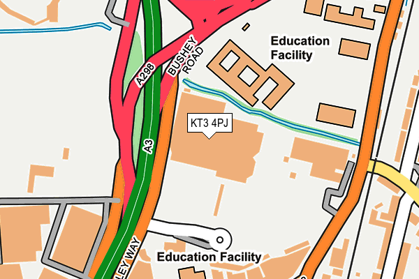
KT3 4PJ is located in the West Barnes electoral ward, within the London borough of Merton and the English Parliamentary constituency of Wimbledon. The Sub Integrated Care Board (ICB) Location is NHS South West London ICB - 36L and the police force is Metropolitan Police. This postcode has been in use since October 1987.


GetTheData
Source: OS OpenMap – Local (Ordnance Survey)
Source: OS VectorMap District (Ordnance Survey)
Licence: Open Government Licence (requires attribution)
| Easting | 522500 |
| Northing | 168506 |
| Latitude | 51.402364 |
| Longitude | -0.240310 |
GetTheData
Source: Open Postcode Geo
Licence: Open Government Licence
| Country | England |
| Postcode District | KT3 |
➜ See where KT3 is on a map ➜ Where is London? | |
GetTheData
Source: Land Registry Price Paid Data
Licence: Open Government Licence
Elevation or altitude of KT3 4PJ as distance above sea level:
| Metres | Feet | |
|---|---|---|
| Elevation | 20m | 66ft |
Elevation is measured from the approximate centre of the postcode, to the nearest point on an OS contour line from OS Terrain 50, which has contour spacing of ten vertical metres.
➜ How high above sea level am I? Find the elevation of your current position using your device's GPS.
GetTheData
Source: Open Postcode Elevation
Licence: Open Government Licence
| Ward | West Barnes |
| Constituency | Wimbledon |
GetTheData
Source: ONS Postcode Database
Licence: Open Government Licence
| Shannon Corner Superstores (Beverley Way) | West Barnes | 60m |
| Raynes Park High School | West Barnes | 95m |
| Beverley Park Golf Range | West Barnes | 182m |
| Shannon Corner | West Barnes | 202m |
| Shannon Corner Beverley Way (Beverley Way) | West Barnes | 218m |
| Motspur Park Station | 0.8km |
| Raynes Park Station | 1km |
| New Malden Station | 1.1km |
GetTheData
Source: NaPTAN
Licence: Open Government Licence
GetTheData
Source: ONS Postcode Database
Licence: Open Government Licence


➜ Get more ratings from the Food Standards Agency
GetTheData
Source: Food Standards Agency
Licence: FSA terms & conditions
| Last Collection | |||
|---|---|---|---|
| Location | Mon-Fri | Sat | Distance |
| West Barnes Post Office | 17:45 | 12:15 | 309m |
| Hidcote Gardens | 16:00 | 12:00 | 417m |
| 19 Westway | 16:00 | 12:00 | 441m |
GetTheData
Source: Dracos
Licence: Creative Commons Attribution-ShareAlike
| Risk of KT3 4PJ flooding from rivers and sea | Medium |
| ➜ KT3 4PJ flood map | |
GetTheData
Source: Open Flood Risk by Postcode
Licence: Open Government Licence
The below table lists the International Territorial Level (ITL) codes (formerly Nomenclature of Territorial Units for Statistics (NUTS) codes) and Local Administrative Units (LAU) codes for KT3 4PJ:
| ITL 1 Code | Name |
|---|---|
| TLI | London |
| ITL 2 Code | Name |
| TLI6 | Outer London - South |
| ITL 3 Code | Name |
| TLI63 | Merton, Kingston upon Thames and Sutton |
| LAU 1 Code | Name |
| E09000024 | Merton |
GetTheData
Source: ONS Postcode Directory
Licence: Open Government Licence
The below table lists the Census Output Area (OA), Lower Layer Super Output Area (LSOA), and Middle Layer Super Output Area (MSOA) for KT3 4PJ:
| Code | Name | |
|---|---|---|
| OA | E00017545 | |
| LSOA | E01003471 | Merton 016E |
| MSOA | E02000704 | Merton 016 |
GetTheData
Source: ONS Postcode Directory
Licence: Open Government Licence
| KT3 4NL | Burlington Road | 274m |
| KT3 4PS | West Barnes Lane | 276m |
| KT3 6HP | West Barnes Lane | 281m |
| KT3 4NN | Burlington Road | 303m |
| SW20 9AX | Linkway | 303m |
| KT3 6JP | Seaforth Avenue | 308m |
| KT3 4NW | Burlington Road | 312m |
| KT3 4PW | West Barnes Lane | 314m |
| SW20 9AZ | Linkway | 326m |
| KT3 4PP | West Barnes Lane | 332m |
GetTheData
Source: Open Postcode Geo; Land Registry Price Paid Data
Licence: Open Government Licence