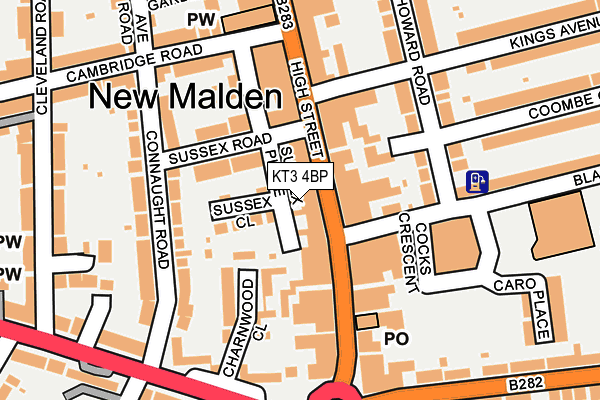
KT3 4BP lies on High Street in New Malden. KT3 4BP is located in the New Malden Village electoral ward, within the London borough of Kingston upon Thames and the English Parliamentary constituency of Kingston and Surbiton. The Sub Integrated Care Board (ICB) Location is NHS South West London ICB - 36L and the police force is Metropolitan Police. This postcode has been in use since January 1980.


GetTheData
Source: OS OpenMap – Local (Ordnance Survey)
Source: OS VectorMap District (Ordnance Survey)
Licence: Open Government Licence (requires attribution)
| Easting | 521411 |
| Northing | 168280 |
| Latitude | 51.400567 |
| Longitude | -0.256035 |
GetTheData
Source: Open Postcode Geo
Licence: Open Government Licence
| Street | High Street |
| Town/City | New Malden |
| Country | England |
| Postcode District | KT3 |
➜ See where KT3 is on a map ➜ Where is New Malden? | |
GetTheData
Source: Land Registry Price Paid Data
Licence: Open Government Licence
Elevation or altitude of KT3 4BP as distance above sea level:
| Metres | Feet | |
|---|---|---|
| Elevation | 20m | 66ft |
Elevation is measured from the approximate centre of the postcode, to the nearest point on an OS contour line from OS Terrain 50, which has contour spacing of ten vertical metres.
➜ How high above sea level am I? Find the elevation of your current position using your device's GPS.
GetTheData
Source: Open Postcode Elevation
Licence: Open Government Licence
| Ward | New Malden Village |
| Constituency | Kingston And Surbiton |
GetTheData
Source: ONS Postcode Database
Licence: Open Government Licence
| New Malden High Street | New Malden | 24m |
| New Malden High Street | New Malden | 39m |
| New Malden The Fountain (Kingston Road) | New Malden | 212m |
| New Malden The Fountain (Kingston Road) | New Malden | 220m |
| Walton Avenue (Burlington Road) | New Malden | 245m |
| New Malden Station | 0.4km |
| Motspur Park Station | 1.3km |
| Berrylands Station | 1.7km |
GetTheData
Source: NaPTAN
Licence: Open Government Licence
| Median download speed | 16.1Mbps |
| Average download speed | 13.3Mbps |
| Maximum download speed | 19.93Mbps |
| Median upload speed | 0.9Mbps |
| Average upload speed | 0.9Mbps |
| Maximum upload speed | 1.24Mbps |
GetTheData
Source: Ofcom
Licence: Ofcom Terms of Use (requires attribution)
GetTheData
Source: ONS Postcode Database
Licence: Open Government Licence


➜ Get more ratings from the Food Standards Agency
GetTheData
Source: Food Standards Agency
Licence: FSA terms & conditions
| Last Collection | |||
|---|---|---|---|
| Location | Mon-Fri | Sat | Distance |
| New Malden Post Office | 18:15 | 12:45 | 155m |
| High Street | 17:30 | 12:00 | 159m |
| Dukes Avenue | 17:30 | 12:00 | 294m |
GetTheData
Source: Dracos
Licence: Creative Commons Attribution-ShareAlike
The below table lists the International Territorial Level (ITL) codes (formerly Nomenclature of Territorial Units for Statistics (NUTS) codes) and Local Administrative Units (LAU) codes for KT3 4BP:
| ITL 1 Code | Name |
|---|---|
| TLI | London |
| ITL 2 Code | Name |
| TLI6 | Outer London - South |
| ITL 3 Code | Name |
| TLI63 | Merton, Kingston upon Thames and Sutton |
| LAU 1 Code | Name |
| E09000021 | Kingston upon Thames |
GetTheData
Source: ONS Postcode Directory
Licence: Open Government Licence
The below table lists the Census Output Area (OA), Lower Layer Super Output Area (LSOA), and Middle Layer Super Output Area (MSOA) for KT3 4BP:
| Code | Name | |
|---|---|---|
| OA | E00014755 | |
| LSOA | E01002930 | Kingston upon Thames 007B |
| MSOA | E02000604 | Kingston upon Thames 007 |
GetTheData
Source: ONS Postcode Directory
Licence: Open Government Licence
| KT3 3PU | Sussex Place | 9m |
| KT3 4EU | High Street | 42m |
| KT3 4ET | High Street | 70m |
| KT3 3PT | Sussex Close | 75m |
| KT3 4BN | Firman Close | 76m |
| KT3 3PY | Sussex Road | 77m |
| KT3 4BT | High Street | 101m |
| KT3 4DX | Kings Avenue | 109m |
| KT3 3PX | Sussex Place | 114m |
| KT3 4EB | Howard Road | 115m |
GetTheData
Source: Open Postcode Geo; Land Registry Price Paid Data
Licence: Open Government Licence