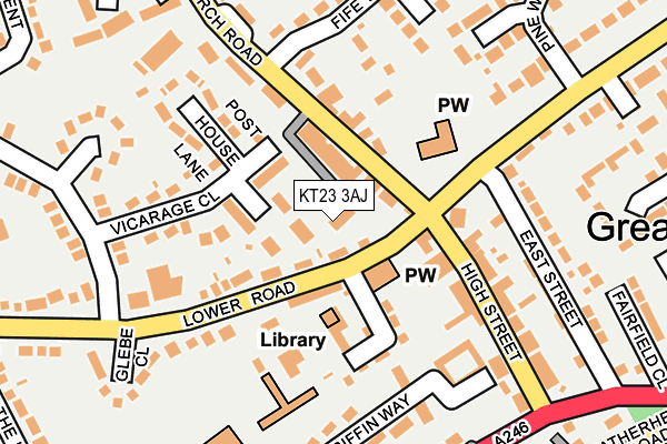
KT23 3AJ is located in the Bookham West electoral ward, within the local authority district of Mole Valley and the English Parliamentary constituency of Mole Valley. The Sub Integrated Care Board (ICB) Location is NHS Surrey Heartlands ICB - 92A and the police force is Surrey. This postcode has been in use since April 2012.


GetTheData
Source: OS OpenMap – Local (Ordnance Survey)
Source: OS VectorMap District (Ordnance Survey)
Licence: Open Government Licence (requires attribution)
| Easting | 513421 |
| Northing | 154597 |
| Latitude | 51.279234 |
| Longitude | -0.375198 |
GetTheData
Source: Open Postcode Geo
Licence: Open Government Licence
| Country | England |
| Postcode District | KT23 |
➜ See where KT23 is on a map ➜ Where is Great Bookham? | |
GetTheData
Source: Land Registry Price Paid Data
Licence: Open Government Licence
Elevation or altitude of KT23 3AJ as distance above sea level:
| Metres | Feet | |
|---|---|---|
| Elevation | 60m | 197ft |
Elevation is measured from the approximate centre of the postcode, to the nearest point on an OS contour line from OS Terrain 50, which has contour spacing of ten vertical metres.
➜ How high above sea level am I? Find the elevation of your current position using your device's GPS.
GetTheData
Source: Open Postcode Elevation
Licence: Open Government Licence
| Ward | Bookham West |
| Constituency | Mole Valley |
GetTheData
Source: ONS Postcode Database
Licence: Open Government Licence
| Old Crown (Lower Road) | Great Bookham | 113m |
| Old Crown (Lower Road) | Great Bookham | 157m |
| Rayleigh House (Guildford Road) | Great Bookham | 252m |
| The Park (Church Road) | Great Bookham | 263m |
| Rayleigh House (Guildford Road) | Great Bookham | 279m |
| Bookham Station | 1.2km |
| Effingham Junction Station | 3.4km |
| Leatherhead Station | 3.6km |
GetTheData
Source: NaPTAN
Licence: Open Government Licence
Estimated total energy consumption in KT23 3AJ by fuel type, 2015.
| Consumption (kWh) | 40,409 |
|---|---|
| Meter count | 8 |
| Mean (kWh/meter) | 5,051 |
| Median (kWh/meter) | 4,694 |
| Consumption (kWh) | 22,376 |
|---|---|
| Meter count | 12 |
| Mean (kWh/meter) | 1,865 |
| Median (kWh/meter) | 1,265 |
GetTheData
Source: Postcode level gas estimates: 2015 (experimental)
Source: Postcode level electricity estimates: 2015 (experimental)
Licence: Open Government Licence
GetTheData
Source: ONS Postcode Database
Licence: Open Government Licence


➜ Get more ratings from the Food Standards Agency
GetTheData
Source: Food Standards Agency
Licence: FSA terms & conditions
| Last Collection | |||
|---|---|---|---|
| Location | Mon-Fri | Sat | Distance |
| Great Bookham Post Office | 17:45 | 12:15 | 44m |
| Lower Shott | 17:15 | 11:00 | 310m |
| Church Road | 17:30 | 12:00 | 472m |
GetTheData
Source: Dracos
Licence: Creative Commons Attribution-ShareAlike
The below table lists the International Territorial Level (ITL) codes (formerly Nomenclature of Territorial Units for Statistics (NUTS) codes) and Local Administrative Units (LAU) codes for KT23 3AJ:
| ITL 1 Code | Name |
|---|---|
| TLJ | South East (England) |
| ITL 2 Code | Name |
| TLJ2 | Surrey, East and West Sussex |
| ITL 3 Code | Name |
| TLJ26 | East Surrey |
| LAU 1 Code | Name |
| E07000210 | Mole Valley |
GetTheData
Source: ONS Postcode Directory
Licence: Open Government Licence
The below table lists the Census Output Area (OA), Lower Layer Super Output Area (LSOA), and Middle Layer Super Output Area (MSOA) for KT23 3AJ:
| Code | Name | |
|---|---|---|
| OA | E00155655 | |
| LSOA | E01030516 | Mole Valley 006A |
| MSOA | E02006367 | Mole Valley 006 |
GetTheData
Source: ONS Postcode Directory
Licence: Open Government Licence
| KT23 3PD | Church Road | 37m |
| KT23 3EE | Yeomans Croft | 47m |
| KT23 3PG | Church Road | 59m |
| KT23 3QB | Church Road | 64m |
| KT23 4DG | Lower Road | 72m |
| KT23 3EA | Post House Lane | 84m |
| KT23 3PW | Church Road | 101m |
| KT23 4DE | Lower Road | 105m |
| KT23 4DQ | Townshott Close | 120m |
| KT23 4DH | Lower Road | 151m |
GetTheData
Source: Open Postcode Geo; Land Registry Price Paid Data
Licence: Open Government Licence