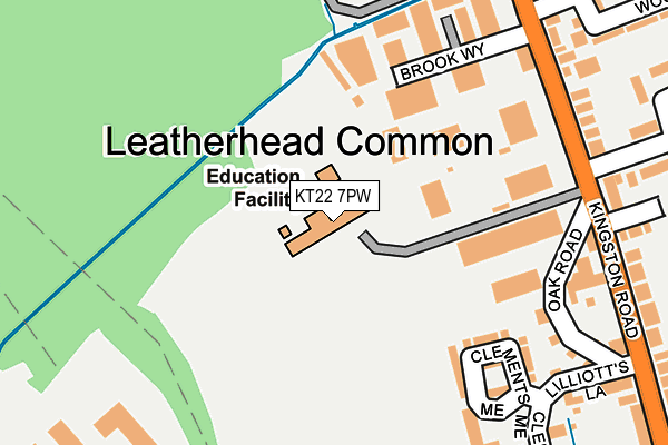
KT22 7PW is located in the Leatherhead North electoral ward, within the local authority district of Mole Valley and the English Parliamentary constituency of Mole Valley. The Sub Integrated Care Board (ICB) Location is NHS Surrey Heartlands ICB - 92A and the police force is Surrey. This postcode has been in use since January 1980.


GetTheData
Source: OS OpenMap – Local (Ordnance Survey)
Source: OS VectorMap District (Ordnance Survey)
Licence: Open Government Licence (requires attribution)
| Easting | 516074 |
| Northing | 158050 |
| Latitude | 51.309736 |
| Longitude | -0.336056 |
GetTheData
Source: Open Postcode Geo
Licence: Open Government Licence
| Country | England |
| Postcode District | KT22 |
➜ See where KT22 is on a map | |
GetTheData
Source: Land Registry Price Paid Data
Licence: Open Government Licence
Elevation or altitude of KT22 7PW as distance above sea level:
| Metres | Feet | |
|---|---|---|
| Elevation | 40m | 131ft |
Elevation is measured from the approximate centre of the postcode, to the nearest point on an OS contour line from OS Terrain 50, which has contour spacing of ten vertical metres.
➜ How high above sea level am I? Find the elevation of your current position using your device's GPS.
GetTheData
Source: Open Postcode Elevation
Licence: Open Government Licence
| Ward | Leatherhead North |
| Constituency | Mole Valley |
GetTheData
Source: ONS Postcode Database
Licence: Open Government Licence
| Regent Park (Kingston Road) | Leatherhead | 227m |
| Tesco (Oxshott Road) | Leatherhead | 241m |
| Regent Park (Kingston Road) | Leatherhead | 248m |
| The Royal Oak (Kingston Road) | Leatherhead | 269m |
| The Royal Oak (Kingston Road) | Leatherhead | 269m |
| Leatherhead Station | 1.2km |
| Ashtead Station | 2.2km |
| Oxshott Station | 3.5km |
GetTheData
Source: NaPTAN
Licence: Open Government Licence
GetTheData
Source: ONS Postcode Database
Licence: Open Government Licence


➜ Get more ratings from the Food Standards Agency
GetTheData
Source: Food Standards Agency
Licence: FSA terms & conditions
| Last Collection | |||
|---|---|---|---|
| Location | Mon-Fri | Sat | Distance |
| Clements Mead | 16:30 | 11:30 | 233m |
| Woodbridge | 17:30 | 12:00 | 257m |
| Leatherhead Common Post Office | 17:30 | 12:00 | 409m |
GetTheData
Source: Dracos
Licence: Creative Commons Attribution-ShareAlike
The below table lists the International Territorial Level (ITL) codes (formerly Nomenclature of Territorial Units for Statistics (NUTS) codes) and Local Administrative Units (LAU) codes for KT22 7PW:
| ITL 1 Code | Name |
|---|---|
| TLJ | South East (England) |
| ITL 2 Code | Name |
| TLJ2 | Surrey, East and West Sussex |
| ITL 3 Code | Name |
| TLJ26 | East Surrey |
| LAU 1 Code | Name |
| E07000210 | Mole Valley |
GetTheData
Source: ONS Postcode Directory
Licence: Open Government Licence
The below table lists the Census Output Area (OA), Lower Layer Super Output Area (LSOA), and Middle Layer Super Output Area (MSOA) for KT22 7PW:
| Code | Name | |
|---|---|---|
| OA | E00155806 | |
| LSOA | E01030551 | Mole Valley 003D |
| MSOA | E02006364 | Mole Valley 003 |
GetTheData
Source: ONS Postcode Directory
Licence: Open Government Licence
| KT22 7RN | Clements Mead | 190m |
| KT22 7PH | Oak Road | 220m |
| KT22 7PJ | Kingston Road | 228m |
| KT22 7QA | Kingston Road | 241m |
| KT22 7RE | Kingston Road | 268m |
| KT22 7FN | Clements Mead | 269m |
| KT22 7QD | Kingston Road | 274m |
| KT22 7PZ | Kingston Road | 283m |
| KT22 7RP | Clements Mead | 300m |
| KT22 7QR | The Fairway | 328m |
GetTheData
Source: Open Postcode Geo; Land Registry Price Paid Data
Licence: Open Government Licence