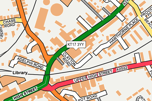
KT17 3YY is located in the Town electoral ward, within the local authority district of Epsom and Ewell and the English Parliamentary constituency of Epsom and Ewell. The Sub Integrated Care Board (ICB) Location is NHS Surrey Heartlands ICB - 92A and the police force is Surrey. This postcode has been in use since December 2000.


GetTheData
Source: OS OpenMap – Local (Ordnance Survey)
Source: OS VectorMap District (Ordnance Survey)
Licence: Open Government Licence (requires attribution)
| Easting | 521139 |
| Northing | 161014 |
| Latitude | 51.335322 |
| Longitude | -0.262440 |
GetTheData
Source: Open Postcode Geo
Licence: Open Government Licence
| Country | England |
| Postcode District | KT17 |
➜ See where KT17 is on a map ➜ Where is Epsom? | |
GetTheData
Source: Land Registry Price Paid Data
Licence: Open Government Licence
Elevation or altitude of KT17 3YY as distance above sea level:
| Metres | Feet | |
|---|---|---|
| Elevation | 50m | 164ft |
Elevation is measured from the approximate centre of the postcode, to the nearest point on an OS contour line from OS Terrain 50, which has contour spacing of ten vertical metres.
➜ How high above sea level am I? Find the elevation of your current position using your device's GPS.
GetTheData
Source: Open Postcode Elevation
Licence: Open Government Licence
| Ward | Town |
| Constituency | Epsom And Ewell |
GetTheData
Source: ONS Postcode Database
Licence: Open Government Licence
| Rainbow Leisure Centre (East Street) | Epsom | 101m |
| The Odeon (Upper High Street) | Epsom | 114m |
| Rainbow Leisure Centre (East Street) | Epsom | 149m |
| The Odeon (Upper High Street) | Epsom | 151m |
| High Street | Epsom | 251m |
| Epsom Station | 0.5km |
| Ewell West Station | 1.7km |
| Ewell East Station | 1.8km |
GetTheData
Source: NaPTAN
Licence: Open Government Licence
GetTheData
Source: ONS Postcode Database
Licence: Open Government Licence


➜ Get more ratings from the Food Standards Agency
GetTheData
Source: Food Standards Agency
Licence: FSA terms & conditions
| Last Collection | |||
|---|---|---|---|
| Location | Mon-Fri | Sat | Distance |
| Upper High Street | 18:00 | 12:45 | 140m |
| Epsom Sorting Office | 19:30 | 13:00 | 220m |
| Epsom Railway Station | 19:00 | 12:30 | 415m |
GetTheData
Source: Dracos
Licence: Creative Commons Attribution-ShareAlike
The below table lists the International Territorial Level (ITL) codes (formerly Nomenclature of Territorial Units for Statistics (NUTS) codes) and Local Administrative Units (LAU) codes for KT17 3YY:
| ITL 1 Code | Name |
|---|---|
| TLJ | South East (England) |
| ITL 2 Code | Name |
| TLJ2 | Surrey, East and West Sussex |
| ITL 3 Code | Name |
| TLJ26 | East Surrey |
| LAU 1 Code | Name |
| E07000208 | Epsom and Ewell |
GetTheData
Source: ONS Postcode Directory
Licence: Open Government Licence
The below table lists the Census Output Area (OA), Lower Layer Super Output Area (LSOA), and Middle Layer Super Output Area (MSOA) for KT17 3YY:
| Code | Name | |
|---|---|---|
| OA | E00155119 | |
| LSOA | E01030412 | Epsom and Ewell 008C |
| MSOA | E02006342 | Epsom and Ewell 008 |
GetTheData
Source: ONS Postcode Directory
Licence: Open Government Licence
| KT17 1JA | Prospect Place | 39m |
| KT17 1HS | East Street | 66m |
| KT17 1HZ | Clayton Road | 67m |
| KT17 1BL | East Street | 68m |
| KT17 1BD | East Street | 71m |
| KT17 1HQ | East Street | 77m |
| KT17 1HH | East Street | 110m |
| KT17 4QY | Upper High Street | 113m |
| KT17 4RA | Upper High Street | 116m |
| KT19 8TH | Hook Road | 118m |
GetTheData
Source: Open Postcode Geo; Land Registry Price Paid Data
Licence: Open Government Licence