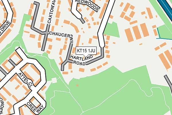
KT15 1JU lies on Hartland Road in Addlestone. KT15 1JU is located in the Woodham & Rowtown electoral ward, within the local authority district of Runnymede and the English Parliamentary constituency of Runnymede and Weybridge. The Sub Integrated Care Board (ICB) Location is NHS Surrey Heartlands ICB - 92A and the police force is Surrey. This postcode has been in use since January 1980.


GetTheData
Source: OS OpenMap – Local (Ordnance Survey)
Source: OS VectorMap District (Ordnance Survey)
Licence: Open Government Licence (requires attribution)
| Easting | 504307 |
| Northing | 163444 |
| Latitude | 51.360497 |
| Longitude | -0.503236 |
GetTheData
Source: Open Postcode Geo
Licence: Open Government Licence
| Street | Hartland Road |
| Town/City | Addlestone |
| Country | England |
| Postcode District | KT15 |
➜ See where KT15 is on a map ➜ Where is Row Town? | |
GetTheData
Source: Land Registry Price Paid Data
Licence: Open Government Licence
Elevation or altitude of KT15 1JU as distance above sea level:
| Metres | Feet | |
|---|---|---|
| Elevation | 30m | 98ft |
Elevation is measured from the approximate centre of the postcode, to the nearest point on an OS contour line from OS Terrain 50, which has contour spacing of ten vertical metres.
➜ How high above sea level am I? Find the elevation of your current position using your device's GPS.
GetTheData
Source: Open Postcode Elevation
Licence: Open Government Licence
| Ward | Woodham & Rowtown |
| Constituency | Runnymede And Weybridge |
GetTheData
Source: ONS Postcode Database
Licence: Open Government Licence
| Coombelands Ongar Hill (Ongar Hill) | Row Town | 386m |
| Coombelands Ongar Hill (Ongar Hill) | Row Town | 402m |
| Franklands Drive (Rowtown) | Row Town | 437m |
| Franklands Drive (Rowtown) | Row Town | 438m |
| Ongar Close (Ongar Hill) | Row Town | 569m |
| Addlestone Station | 1.9km |
| Byfleet & New Haw Station | 1.9km |
| West Byfleet Station | 2.4km |
GetTheData
Source: NaPTAN
Licence: Open Government Licence
| Percentage of properties with Next Generation Access | 100.0% |
| Percentage of properties with Superfast Broadband | 100.0% |
| Percentage of properties with Ultrafast Broadband | 0.0% |
| Percentage of properties with Full Fibre Broadband | 0.0% |
Superfast Broadband is between 30Mbps and 300Mbps
Ultrafast Broadband is > 300Mbps
| Percentage of properties unable to receive 2Mbps | 0.0% |
| Percentage of properties unable to receive 5Mbps | 0.0% |
| Percentage of properties unable to receive 10Mbps | 0.0% |
| Percentage of properties unable to receive 30Mbps | 0.0% |
GetTheData
Source: Ofcom
Licence: Ofcom Terms of Use (requires attribution)
GetTheData
Source: ONS Postcode Database
Licence: Open Government Licence


➜ Get more ratings from the Food Standards Agency
GetTheData
Source: Food Standards Agency
Licence: FSA terms & conditions
| Last Collection | |||
|---|---|---|---|
| Location | Mon-Fri | Sat | Distance |
| Ongar Parade Post Office | 17:15 | 12:00 | 378m |
| Rowtown | 17:15 | 11:45 | 436m |
| Malus Drive | 17:15 | 11:45 | 645m |
GetTheData
Source: Dracos
Licence: Creative Commons Attribution-ShareAlike
The below table lists the International Territorial Level (ITL) codes (formerly Nomenclature of Territorial Units for Statistics (NUTS) codes) and Local Administrative Units (LAU) codes for KT15 1JU:
| ITL 1 Code | Name |
|---|---|
| TLJ | South East (England) |
| ITL 2 Code | Name |
| TLJ2 | Surrey, East and West Sussex |
| ITL 3 Code | Name |
| TLJ25 | West Surrey |
| LAU 1 Code | Name |
| E07000212 | Runnymede |
GetTheData
Source: ONS Postcode Directory
Licence: Open Government Licence
The below table lists the Census Output Area (OA), Lower Layer Super Output Area (LSOA), and Middle Layer Super Output Area (MSOA) for KT15 1JU:
| Code | Name | |
|---|---|---|
| OA | E00156366 | |
| LSOA | E01030660 | Runnymede 009C |
| MSOA | E02006401 | Runnymede 009 |
GetTheData
Source: ONS Postcode Directory
Licence: Open Government Licence
| KT15 1JX | Hartland Road | 34m |
| KT15 1JZ | Hartland Road | 42m |
| KT15 1JY | Hartland Road | 45m |
| KT15 1LA | Hartland Road | 48m |
| KT15 1LB | Hartland Road | 68m |
| KT15 1JS | Hartland Road | 71m |
| KT15 1LG | Chaucer Way | 76m |
| KT15 1LD | Hartland Road | 83m |
| KT15 1JT | Hartland Road | 85m |
| KT15 1JR | Farm Lane | 89m |
GetTheData
Source: Open Postcode Geo; Land Registry Price Paid Data
Licence: Open Government Licence