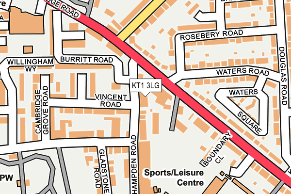
KT1 3LG is located in the Norbiton electoral ward, within the London borough of Kingston upon Thames and the English Parliamentary constituency of Kingston and Surbiton. The Sub Integrated Care Board (ICB) Location is NHS South West London ICB - 36L and the police force is Metropolitan Police. This postcode has been in use since December 1995.


GetTheData
Source: OS OpenMap – Local (Ordnance Survey)
Source: OS VectorMap District (Ordnance Survey)
Licence: Open Government Licence (requires attribution)
| Easting | 519433 |
| Northing | 168973 |
| Latitude | 51.407215 |
| Longitude | -0.284224 |
GetTheData
Source: Open Postcode Geo
Licence: Open Government Licence
| Country | England |
| Postcode District | KT1 |
➜ See where KT1 is on a map ➜ Where is London? | |
GetTheData
Source: Land Registry Price Paid Data
Licence: Open Government Licence
Elevation or altitude of KT1 3LG as distance above sea level:
| Metres | Feet | |
|---|---|---|
| Elevation | 20m | 66ft |
Elevation is measured from the approximate centre of the postcode, to the nearest point on an OS contour line from OS Terrain 50, which has contour spacing of ten vertical metres.
➜ How high above sea level am I? Find the elevation of your current position using your device's GPS.
GetTheData
Source: Open Postcode Elevation
Licence: Open Government Licence
| Ward | Norbiton |
| Constituency | Kingston And Surbiton |
GetTheData
Source: ONS Postcode Database
Licence: Open Government Licence
| Waters Road (Cambridge Road) | Norbiton | 94m |
| Waters Road | Norbiton | 108m |
| Kingsmeadow (Kingston Road) | Norbiton | 177m |
| Cambridge Grove (Cambridge Road) | Norbiton | 251m |
| Cambridge Grove (Cambridge Road) | Norbiton | 256m |
| Norbiton Station | 0.6km |
| Berrylands Station | 0.9km |
| Kingston Station | 1.3km |
GetTheData
Source: NaPTAN
Licence: Open Government Licence
GetTheData
Source: ONS Postcode Database
Licence: Open Government Licence


➜ Get more ratings from the Food Standards Agency
GetTheData
Source: Food Standards Agency
Licence: FSA terms & conditions
| Last Collection | |||
|---|---|---|---|
| Location | Mon-Fri | Sat | Distance |
| Cambdridge Grove Road | 17:45 | 12:15 | 201m |
| Kingston Boundary | 17:30 | 12:00 | 271m |
| Cambridge Gardens | 17:30 | 12:00 | 282m |
GetTheData
Source: Dracos
Licence: Creative Commons Attribution-ShareAlike
The below table lists the International Territorial Level (ITL) codes (formerly Nomenclature of Territorial Units for Statistics (NUTS) codes) and Local Administrative Units (LAU) codes for KT1 3LG:
| ITL 1 Code | Name |
|---|---|
| TLI | London |
| ITL 2 Code | Name |
| TLI6 | Outer London - South |
| ITL 3 Code | Name |
| TLI63 | Merton, Kingston upon Thames and Sutton |
| LAU 1 Code | Name |
| E09000021 | Kingston upon Thames |
GetTheData
Source: ONS Postcode Directory
Licence: Open Government Licence
The below table lists the Census Output Area (OA), Lower Layer Super Output Area (LSOA), and Middle Layer Super Output Area (MSOA) for KT1 3LG:
| Code | Name | |
|---|---|---|
| OA | E00014971 | |
| LSOA | E01002970 | Kingston upon Thames 006D |
| MSOA | E02000603 | Kingston upon Thames 006 |
GetTheData
Source: ONS Postcode Directory
Licence: Open Government Licence
| KT1 3LS | Cambridge Road | 75m |
| KT1 3NX | Cambridge Road | 88m |
| KT1 3LT | Cambridge Road | 102m |
| KT1 3HP | Burritt Road | 109m |
| KT1 3HJ | Vincent Road | 111m |
| KT1 3HN | Stapleford Close | 113m |
| KT1 3LE | Cambridge Road | 118m |
| KT1 3HF | Bonner Hill Road | 122m |
| KT1 3HG | Hampden Road | 124m |
| KT1 3LU | Cambridge Road | 134m |
GetTheData
Source: Open Postcode Geo; Land Registry Price Paid Data
Licence: Open Government Licence