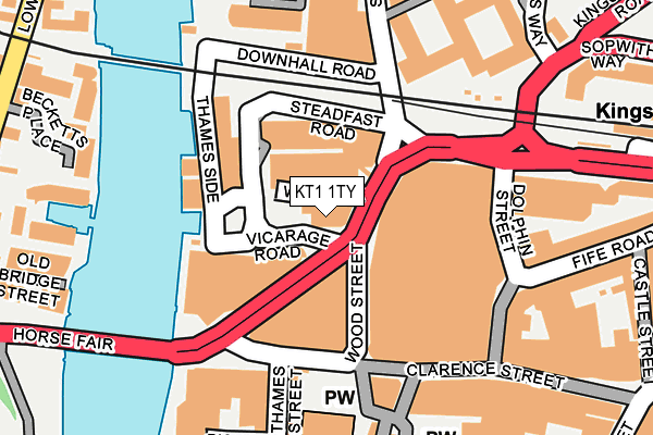
KT1 1TY is located in the Kingston Town electoral ward, within the London borough of Kingston upon Thames and the English Parliamentary constituency of Kingston and Surbiton. The Sub Integrated Care Board (ICB) Location is NHS South West London ICB - 36L and the police force is Metropolitan Police. This postcode has been in use since January 1980.


GetTheData
Source: OS OpenMap – Local (Ordnance Survey)
Source: OS VectorMap District (Ordnance Survey)
Licence: Open Government Licence (requires attribution)
| Easting | 517919 |
| Northing | 169502 |
| Latitude | 51.412286 |
| Longitude | -0.305806 |
GetTheData
Source: Open Postcode Geo
Licence: Open Government Licence
| Country | England |
| Postcode District | KT1 |
➜ See where KT1 is on a map ➜ Where is Kingston upon Thames? | |
GetTheData
Source: Land Registry Price Paid Data
Licence: Open Government Licence
Elevation or altitude of KT1 1TY as distance above sea level:
| Metres | Feet | |
|---|---|---|
| Elevation | 10m | 33ft |
Elevation is measured from the approximate centre of the postcode, to the nearest point on an OS contour line from OS Terrain 50, which has contour spacing of ten vertical metres.
➜ How high above sea level am I? Find the elevation of your current position using your device's GPS.
GetTheData
Source: Open Postcode Elevation
Licence: Open Government Licence
| Ward | Kingston Town |
| Constituency | Kingston And Surbiton |
GetTheData
Source: ONS Postcode Database
Licence: Open Government Licence
| Wood Street | Kingston Upon Thames | 82m |
| Wood Street | Kingston Upon Thames | 93m |
| Wood Street | Kingston Upon Thames | 98m |
| All Saints Church Clarence St (Clarence Street) | Kingston Upon Thames | 146m |
| Kingston (Wood Street) | Kingston Upon Thames | 188m |
| Kingston Station | 0.3km |
| Hampton Wick Station | 0.5km |
| Norbiton Station | 1.5km |
GetTheData
Source: NaPTAN
Licence: Open Government Licence
| Percentage of properties with Next Generation Access | 100.0% |
| Percentage of properties with Superfast Broadband | 100.0% |
| Percentage of properties with Ultrafast Broadband | 0.0% |
| Percentage of properties with Full Fibre Broadband | 0.0% |
Superfast Broadband is between 30Mbps and 300Mbps
Ultrafast Broadband is > 300Mbps
| Percentage of properties unable to receive 2Mbps | 0.0% |
| Percentage of properties unable to receive 5Mbps | 0.0% |
| Percentage of properties unable to receive 10Mbps | 0.0% |
| Percentage of properties unable to receive 30Mbps | 0.0% |
GetTheData
Source: Ofcom
Licence: Ofcom Terms of Use (requires attribution)
GetTheData
Source: ONS Postcode Database
Licence: Open Government Licence


➜ Get more ratings from the Food Standards Agency
GetTheData
Source: Food Standards Agency
Licence: FSA terms & conditions
| Last Collection | |||
|---|---|---|---|
| Location | Mon-Fri | Sat | Distance |
| Fife Road | 18:30 | 12:00 | 231m |
| Union Street | 18:45 | 12:15 | 259m |
| Market Place | 18:30 | 12:00 | 263m |
GetTheData
Source: Dracos
Licence: Creative Commons Attribution-ShareAlike
| Risk of KT1 1TY flooding from rivers and sea | Low |
| ➜ KT1 1TY flood map | |
GetTheData
Source: Open Flood Risk by Postcode
Licence: Open Government Licence
The below table lists the International Territorial Level (ITL) codes (formerly Nomenclature of Territorial Units for Statistics (NUTS) codes) and Local Administrative Units (LAU) codes for KT1 1TY:
| ITL 1 Code | Name |
|---|---|
| TLI | London |
| ITL 2 Code | Name |
| TLI6 | Outer London - South |
| ITL 3 Code | Name |
| TLI63 | Merton, Kingston upon Thames and Sutton |
| LAU 1 Code | Name |
| E09000021 | Kingston upon Thames |
GetTheData
Source: ONS Postcode Directory
Licence: Open Government Licence
The below table lists the Census Output Area (OA), Lower Layer Super Output Area (LSOA), and Middle Layer Super Output Area (MSOA) for KT1 1TY:
| Code | Name | |
|---|---|---|
| OA | E00014949 | |
| LSOA | E01002968 | Kingston upon Thames 009C |
| MSOA | E02000606 | Kingston upon Thames 009 |
GetTheData
Source: ONS Postcode Directory
Licence: Open Government Licence
| KT1 1AE | Water Lane | 110m |
| KT1 1PL | Steadfast Road | 141m |
| KT2 5BG | Royal Quarter | 149m |
| KT2 5FH | Down Hall Road | 167m |
| KT2 5AH | Royal Quarter | 176m |
| KT2 5FJ | Skerne Road | 177m |
| KT2 5BJ | Royal Quarter | 186m |
| KT2 5BS | Royal Quarter | 187m |
| KT1 1SZ | Fife Road | 187m |
| KT2 5FP | Skerne Road | 188m |
GetTheData
Source: Open Postcode Geo; Land Registry Price Paid Data
Licence: Open Government Licence