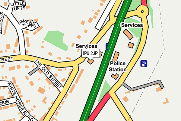
IP9 2JP lies on London Road in Capel St Mary, Ipswich. IP9 2JP is located in the Capel St Mary electoral ward, within the local authority district of Babergh and the English Parliamentary constituency of South Suffolk. The Sub Integrated Care Board (ICB) Location is NHS Suffolk and North East Essex ICB - 06L and the police force is Suffolk. This postcode has been in use since April 1986.


GetTheData
Source: OS OpenMap – Local (Ordnance Survey)
Source: OS VectorMap District (Ordnance Survey)
Licence: Open Government Licence (requires attribution)
| Easting | 609943 |
| Northing | 238283 |
| Latitude | 52.003269 |
| Longitude | 1.057213 |
GetTheData
Source: Open Postcode Geo
Licence: Open Government Licence
| Street | London Road |
| Locality | Capel St Mary |
| Town/City | Ipswich |
| Country | England |
| Postcode District | IP9 |
➜ See where IP9 is on a map ➜ Where is Capel St Mary? | |
GetTheData
Source: Land Registry Price Paid Data
Licence: Open Government Licence
Elevation or altitude of IP9 2JP as distance above sea level:
| Metres | Feet | |
|---|---|---|
| Elevation | 40m | 131ft |
Elevation is measured from the approximate centre of the postcode, to the nearest point on an OS contour line from OS Terrain 50, which has contour spacing of ten vertical metres.
➜ How high above sea level am I? Find the elevation of your current position using your device's GPS.
GetTheData
Source: Open Postcode Elevation
Licence: Open Government Licence
| Ward | Capel St Mary |
| Constituency | South Suffolk |
GetTheData
Source: ONS Postcode Database
Licence: Open Government Licence
| White Horse (London Road) | Capel St Mary | 101m |
| White Horse (London Road) | Capel St Mary | 105m |
| Motel | Capel St Mary | 208m |
| Motel | Capel St Mary | 213m |
| Garrods (Thorney Road) | Capel St Mary | 358m |
GetTheData
Source: NaPTAN
Licence: Open Government Licence
GetTheData
Source: ONS Postcode Database
Licence: Open Government Licence


➜ Get more ratings from the Food Standards Agency
GetTheData
Source: Food Standards Agency
Licence: FSA terms & conditions
| Last Collection | |||
|---|---|---|---|
| Location | Mon-Fri | Sat | Distance |
| Post Office, The Street | 16:45 | 10:00 | 591m |
| Days Green | 16:30 | 09:45 | 1,021m |
| Post Office, Capel Road | 17:00 | 09:45 | 1,891m |
GetTheData
Source: Dracos
Licence: Creative Commons Attribution-ShareAlike
The below table lists the International Territorial Level (ITL) codes (formerly Nomenclature of Territorial Units for Statistics (NUTS) codes) and Local Administrative Units (LAU) codes for IP9 2JP:
| ITL 1 Code | Name |
|---|---|
| TLH | East |
| ITL 2 Code | Name |
| TLH1 | East Anglia |
| ITL 3 Code | Name |
| TLH14 | Suffolk CC |
| LAU 1 Code | Name |
| E07000200 | Babergh |
GetTheData
Source: ONS Postcode Directory
Licence: Open Government Licence
The below table lists the Census Output Area (OA), Lower Layer Super Output Area (LSOA), and Middle Layer Super Output Area (MSOA) for IP9 2JP:
| Code | Name | |
|---|---|---|
| OA | E00152392 | |
| LSOA | E01029903 | Babergh 010E |
| MSOA | E02006236 | Babergh 010 |
GetTheData
Source: ONS Postcode Directory
Licence: Open Government Licence
| IP9 2LF | The Street | 138m |
| IP9 2EA | The Old Street | 158m |
| IP9 2JJ | London Road | 188m |
| IP9 2LL | Thorney Road | 219m |
| IP9 2JR | London Road | 234m |
| IP9 2UB | Great Tufts | 241m |
| IP9 2XE | Homefield | 244m |
| IP9 2XA | White Horse Road | 289m |
| IP9 2EB | The Street | 293m |
| IP9 2UD | Little Tufts | 299m |
GetTheData
Source: Open Postcode Geo; Land Registry Price Paid Data
Licence: Open Government Licence