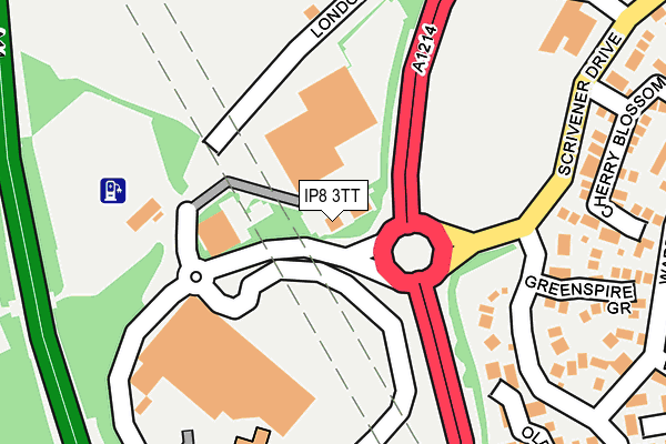
IP8 3TT lies on Copdock Interchange in Ipswich. IP8 3TT is located in the Sproughton & Pinewood electoral ward, within the local authority district of Babergh and the English Parliamentary constituency of South Suffolk. The Sub Integrated Care Board (ICB) Location is NHS Suffolk and North East Essex ICB - 06L and the police force is Suffolk. This postcode has been in use since February 1990.


GetTheData
Source: OS OpenMap – Local (Ordnance Survey)
Source: OS VectorMap District (Ordnance Survey)
Licence: Open Government Licence (requires attribution)
| Easting | 612670 |
| Northing | 242603 |
| Latitude | 52.041015 |
| Longitude | 1.099561 |
GetTheData
Source: Open Postcode Geo
Licence: Open Government Licence
| Street | Copdock Interchange |
| Town/City | Ipswich |
| Country | England |
| Postcode District | IP8 |
➜ See where IP8 is on a map ➜ Where is Ipswich? | |
GetTheData
Source: Land Registry Price Paid Data
Licence: Open Government Licence
Elevation or altitude of IP8 3TT as distance above sea level:
| Metres | Feet | |
|---|---|---|
| Elevation | 40m | 131ft |
Elevation is measured from the approximate centre of the postcode, to the nearest point on an OS contour line from OS Terrain 50, which has contour spacing of ten vertical metres.
➜ How high above sea level am I? Find the elevation of your current position using your device's GPS.
GetTheData
Source: Open Postcode Elevation
Licence: Open Government Licence
| Ward | Sproughton & Pinewood |
| Constituency | South Suffolk |
GetTheData
Source: ONS Postcode Database
Licence: Open Government Licence
| Tesco (On Site) | Copdock | 129m |
| Greenspire Grove (Cottingham Road) | Pinebrook | 207m |
| Greenspire Grove (Cottingham Road) | Pinebrook | 255m |
| Ward Road | Pinebrook | 297m |
| Ward Road | Pinebrook | 309m |
| Ipswich Station | 3.3km |
| Westerfield Station | 6.4km |
GetTheData
Source: NaPTAN
Licence: Open Government Licence
GetTheData
Source: ONS Postcode Database
Licence: Open Government Licence


➜ Get more ratings from the Food Standards Agency
GetTheData
Source: Food Standards Agency
Licence: FSA terms & conditions
| Last Collection | |||
|---|---|---|---|
| Location | Mon-Fri | Sat | Distance |
| A12/A14 Copdock Interchange | 18:30 | 12:20 | 134m |
| 293 Belstead Road | 17:30 | 12:00 | 306m |
| Rookwood, London Road | 15:30 | 09:30 | 725m |
GetTheData
Source: Dracos
Licence: Creative Commons Attribution-ShareAlike
The below table lists the International Territorial Level (ITL) codes (formerly Nomenclature of Territorial Units for Statistics (NUTS) codes) and Local Administrative Units (LAU) codes for IP8 3TT:
| ITL 1 Code | Name |
|---|---|
| TLH | East |
| ITL 2 Code | Name |
| TLH1 | East Anglia |
| ITL 3 Code | Name |
| TLH14 | Suffolk CC |
| LAU 1 Code | Name |
| E07000200 | Babergh |
GetTheData
Source: ONS Postcode Directory
Licence: Open Government Licence
The below table lists the Census Output Area (OA), Lower Layer Super Output Area (LSOA), and Middle Layer Super Output Area (MSOA) for IP8 3TT:
| Code | Name | |
|---|---|---|
| OA | E00152425 | |
| LSOA | E01029909 | Babergh 005E |
| MSOA | E02006231 | Babergh 005 |
GetTheData
Source: ONS Postcode Directory
Licence: Open Government Licence
| IP8 3SA | Cottingham Road | 163m |
| IP8 3LE | London Road | 218m |
| IP8 3SQ | Oldfield Road | 233m |
| IP8 3SZ | Greenspire Grove | 240m |
| IP8 3ST | Cherry Blossom Close | 273m |
| IP8 3SB | Ward Road | 285m |
| IP8 3SE | Oldfield Road | 292m |
| IP8 3SY | Bishop Mews | 300m |
| IP8 3SD | Wilson Road | 359m |
| IP8 3SF | Devlin Road | 398m |
GetTheData
Source: Open Postcode Geo; Land Registry Price Paid Data
Licence: Open Government Licence