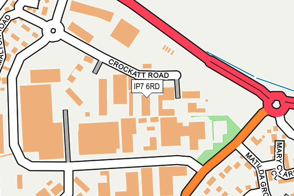
IP7 6RD lies on Crockatt Road in Hadleigh, Ipswich. IP7 6RD is located in the Hadleigh North electoral ward, within the local authority district of Babergh and the English Parliamentary constituency of South Suffolk. The Sub Integrated Care Board (ICB) Location is NHS Suffolk and North East Essex ICB - 06L and the police force is Suffolk. This postcode has been in use since September 2002.


GetTheData
Source: OS OpenMap – Local (Ordnance Survey)
Source: OS VectorMap District (Ordnance Survey)
Licence: Open Government Licence (requires attribution)
| Easting | 603494 |
| Northing | 243542 |
| Latitude | 52.052900 |
| Longitude | 0.966553 |
GetTheData
Source: Open Postcode Geo
Licence: Open Government Licence
| Street | Crockatt Road |
| Locality | Hadleigh |
| Town/City | Ipswich |
| Country | England |
| Postcode District | IP7 |
➜ See where IP7 is on a map ➜ Where is Hadleigh? | |
GetTheData
Source: Land Registry Price Paid Data
Licence: Open Government Licence
Elevation or altitude of IP7 6RD as distance above sea level:
| Metres | Feet | |
|---|---|---|
| Elevation | 50m | 164ft |
Elevation is measured from the approximate centre of the postcode, to the nearest point on an OS contour line from OS Terrain 50, which has contour spacing of ten vertical metres.
➜ How high above sea level am I? Find the elevation of your current position using your device's GPS.
GetTheData
Source: Open Postcode Elevation
Licence: Open Government Licence
| Ward | Hadleigh North |
| Constituency | South Suffolk |
GetTheData
Source: ONS Postcode Database
Licence: Open Government Licence
| Lady Lane Industrial Estate (Access Road) | Hadleigh | 140m |
| Seager Court | Hadleigh | 150m |
| Lady Lane Industrial Estate (Access Road) | Hadleigh | 153m |
| Seager Court | Hadleigh | 164m |
| Lady Lane Industrial Estate (Lady Lane) | Hadleigh | 185m |
GetTheData
Source: NaPTAN
Licence: Open Government Licence
GetTheData
Source: ONS Postcode Database
Licence: Open Government Licence


➜ Get more ratings from the Food Standards Agency
GetTheData
Source: Food Standards Agency
Licence: FSA terms & conditions
| Last Collection | |||
|---|---|---|---|
| Location | Mon-Fri | Sat | Distance |
| Lady Lane Ind Est | 17:30 | 11:45 | 220m |
| Red Hill | 14:00 | 09:45 | 559m |
| 1 Whatfield Road | 15:30 | 09:00 | 1,440m |
GetTheData
Source: Dracos
Licence: Creative Commons Attribution-ShareAlike
The below table lists the International Territorial Level (ITL) codes (formerly Nomenclature of Territorial Units for Statistics (NUTS) codes) and Local Administrative Units (LAU) codes for IP7 6RD:
| ITL 1 Code | Name |
|---|---|
| TLH | East |
| ITL 2 Code | Name |
| TLH1 | East Anglia |
| ITL 3 Code | Name |
| TLH14 | Suffolk CC |
| LAU 1 Code | Name |
| E07000200 | Babergh |
GetTheData
Source: ONS Postcode Directory
Licence: Open Government Licence
The below table lists the Census Output Area (OA), Lower Layer Super Output Area (LSOA), and Middle Layer Super Output Area (MSOA) for IP7 6RD:
| Code | Name | |
|---|---|---|
| OA | E00169911 | |
| LSOA | E01029893 | Babergh 004B |
| MSOA | E02006230 | Babergh 004 |
GetTheData
Source: ONS Postcode Directory
Licence: Open Government Licence
| IP7 6RL | Crockatt Road | 211m |
| IP7 6AG | Grays Close | 234m |
| IP7 6BQ | Lady Lane Industrial Estate | 242m |
| IP7 6FE | Alice Parkins Close | 289m |
| IP7 6AR | Lady Lane | 293m |
| IP7 6FD | Mary Clarke Close | 316m |
| IP7 6FB | Matilda Groome Road | 357m |
| IP7 6AN | Ramsey Road | 382m |
| IP7 6BU | Red Hill Road | 391m |
| IP7 6AH | Brett Avenue | 401m |
GetTheData
Source: Open Postcode Geo; Land Registry Price Paid Data
Licence: Open Government Licence