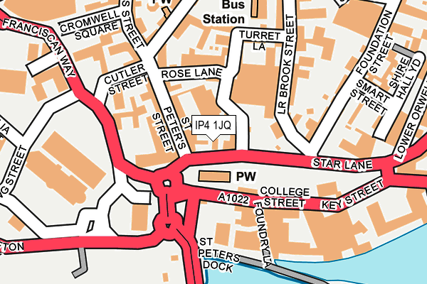
IP4 1JQ is located in the Alexandra electoral ward, within the local authority district of Ipswich and the English Parliamentary constituency of Ipswich. The Sub Integrated Care Board (ICB) Location is NHS Suffolk and North East Essex ICB - 06L and the police force is Suffolk. This postcode has been in use since June 1999.


GetTheData
Source: OS OpenMap – Local (Ordnance Survey)
Source: OS VectorMap District (Ordnance Survey)
Licence: Open Government Licence (requires attribution)
| Easting | 616356 |
| Northing | 244161 |
| Latitude | 52.053576 |
| Longitude | 1.154206 |
GetTheData
Source: Open Postcode Geo
Licence: Open Government Licence
| Country | England |
| Postcode District | IP4 |
➜ See where IP4 is on a map ➜ Where is Ipswich? | |
GetTheData
Source: Land Registry Price Paid Data
Licence: Open Government Licence
Elevation or altitude of IP4 1JQ as distance above sea level:
| Metres | Feet | |
|---|---|---|
| Elevation | 10m | 33ft |
Elevation is measured from the approximate centre of the postcode, to the nearest point on an OS contour line from OS Terrain 50, which has contour spacing of ten vertical metres.
➜ How high above sea level am I? Find the elevation of your current position using your device's GPS.
GetTheData
Source: Open Postcode Elevation
Licence: Open Government Licence
| Ward | Alexandra |
| Constituency | Ipswich |
GetTheData
Source: ONS Postcode Database
Licence: Open Government Licence
| St Peter's Hall (St. Peter's Street) | Ipswich | 65m |
| Dance East (Foundry Lane) | Ipswich | 144m |
| Old Custom House (Key Street) | Ipswich | 219m |
| Revolution (Old Cattle Market (Dogs Head Street)) | Ipswich | 271m |
| Cardinal Park Cinema (Quadling Street) | Ipswich | 279m |
| Ipswich Station | 0.7km |
| Derby Road (Ipswich) Station | 2km |
| Westerfield Station | 3.2km |
GetTheData
Source: NaPTAN
Licence: Open Government Licence
GetTheData
Source: ONS Postcode Database
Licence: Open Government Licence


➜ Get more ratings from the Food Standards Agency
GetTheData
Source: Food Standards Agency
Licence: FSA terms & conditions
| Last Collection | |||
|---|---|---|---|
| Location | Mon-Fri | Sat | Distance |
| 2 St. Peters Street | 18:30 | 12:00 | 120m |
| St Peter's Street | 18:30 | 12:00 | 152m |
| Old Cattle Market | 18:30 | 12:00 | 251m |
GetTheData
Source: Dracos
Licence: Creative Commons Attribution-ShareAlike
| Risk of IP4 1JQ flooding from rivers and sea | Low |
| ➜ IP4 1JQ flood map | |
GetTheData
Source: Open Flood Risk by Postcode
Licence: Open Government Licence
The below table lists the International Territorial Level (ITL) codes (formerly Nomenclature of Territorial Units for Statistics (NUTS) codes) and Local Administrative Units (LAU) codes for IP4 1JQ:
| ITL 1 Code | Name |
|---|---|
| TLH | East |
| ITL 2 Code | Name |
| TLH1 | East Anglia |
| ITL 3 Code | Name |
| TLH14 | Suffolk CC |
| LAU 1 Code | Name |
| E07000202 | Ipswich |
GetTheData
Source: ONS Postcode Directory
Licence: Open Government Licence
The below table lists the Census Output Area (OA), Lower Layer Super Output Area (LSOA), and Middle Layer Super Output Area (MSOA) for IP4 1JQ:
| Code | Name | |
|---|---|---|
| OA | E00170846 | |
| LSOA | E01033124 | Ipswich 007F |
| MSOA | E02006251 | Ipswich 007 |
GetTheData
Source: ONS Postcode Directory
Licence: Open Government Licence
| IP1 1XF | St Peters Street | 92m |
| IP4 1BF | College Street | 96m |
| IP1 1XB | St Peters Street | 111m |
| IP4 1DJ | Foundry Lane | 113m |
| IP1 1XG | St Peters Street | 119m |
| IP4 1DL | Turret Close | 119m |
| IP1 1XE | Rose Lane | 120m |
| IP4 1DT | Turret Lane | 126m |
| IP4 1AQ | Lower Brook Street | 132m |
| IP4 1FP | The Mill | 137m |
GetTheData
Source: Open Postcode Geo; Land Registry Price Paid Data
Licence: Open Government Licence