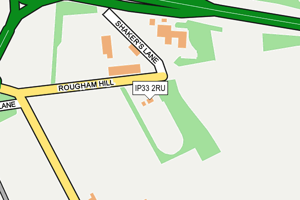
IP33 2RU is located in the Southgate electoral ward, within the local authority district of West Suffolk and the English Parliamentary constituency of Bury St Edmunds. The Sub Integrated Care Board (ICB) Location is NHS Suffolk and North East Essex ICB - 07K and the police force is Suffolk. This postcode has been in use since June 1996.


GetTheData
Source: OS OpenMap – Local (Ordnance Survey)
Source: OS VectorMap District (Ordnance Survey)
Licence: Open Government Licence (requires attribution)
| Easting | 586925 |
| Northing | 263359 |
| Latitude | 52.236696 |
| Longitude | 0.736096 |
GetTheData
Source: Open Postcode Geo
Licence: Open Government Licence
| Country | England |
| Postcode District | IP33 |
➜ See where IP33 is on a map ➜ Where is Bury St Edmunds? | |
GetTheData
Source: Land Registry Price Paid Data
Licence: Open Government Licence
Elevation or altitude of IP33 2RU as distance above sea level:
| Metres | Feet | |
|---|---|---|
| Elevation | 50m | 164ft |
Elevation is measured from the approximate centre of the postcode, to the nearest point on an OS contour line from OS Terrain 50, which has contour spacing of ten vertical metres.
➜ How high above sea level am I? Find the elevation of your current position using your device's GPS.
GetTheData
Source: Open Postcode Elevation
Licence: Open Government Licence
| Ward | Southgate |
| Constituency | Bury St Edmunds |
GetTheData
Source: ONS Postcode Database
Licence: Open Government Licence
| Rougham Rd Roundabout | Bury St Edmunds | 323m |
| Sainsbury's | Moreton Hall | 376m |
| Bp Garage (Rougham Road) | Bury St Edmunds | 395m |
| Sainsbury's (Bedingfeld Way) | Moreton Hall | 397m |
| Greyfriars Road | Moreton Hall | 498m |
| Bury St Edmunds Station | 2.5km |
| Thurston Station | 5.2km |
GetTheData
Source: NaPTAN
Licence: Open Government Licence
Estimated total energy consumption in IP33 2RU by fuel type, 2015.
| Consumption (kWh) | 267,327 |
|---|---|
| Meter count | 9 |
| Mean (kWh/meter) | 29,703 |
| Median (kWh/meter) | 29,703 |
GetTheData
Source: Postcode level gas estimates: 2015 (experimental)
Source: Postcode level electricity estimates: 2015 (experimental)
Licence: Open Government Licence
GetTheData
Source: ONS Postcode Database
Licence: Open Government Licence


➜ Get more ratings from the Food Standards Agency
GetTheData
Source: Food Standards Agency
Licence: FSA terms & conditions
| Last Collection | |||
|---|---|---|---|
| Location | Mon-Fri | Sat | Distance |
| Bedingfield Way | 17:00 | 11:30 | 728m |
| Symonds Road | 17:00 | 11:30 | 794m |
| 72 Nowton Road | 17:15 | 11:30 | 889m |
GetTheData
Source: Dracos
Licence: Creative Commons Attribution-ShareAlike
The below table lists the International Territorial Level (ITL) codes (formerly Nomenclature of Territorial Units for Statistics (NUTS) codes) and Local Administrative Units (LAU) codes for IP33 2RU:
| ITL 1 Code | Name |
|---|---|
| TLH | East |
| ITL 2 Code | Name |
| TLH1 | East Anglia |
| ITL 3 Code | Name |
| TLH14 | Suffolk CC |
| LAU 1 Code | Name |
| E07000245 | West Suffolk |
GetTheData
Source: ONS Postcode Directory
Licence: Open Government Licence
The below table lists the Census Output Area (OA), Lower Layer Super Output Area (LSOA), and Middle Layer Super Output Area (MSOA) for IP33 2RU:
| Code | Name | |
|---|---|---|
| OA | E00153674 | |
| LSOA | E01030144 | St Edmundsbury 009D |
| MSOA | E02006281 | St Edmundsbury 009 |
GetTheData
Source: ONS Postcode Directory
Licence: Open Government Licence
| IP33 2RW | Oaklands Park | 128m |
| IP33 2RR | Rushbrooke Lane | 350m |
| IP33 2RS | Rushbrooke Lane | 351m |
| IP32 7DQ | Eldred Close | 453m |
| IP32 7DG | Raedwald Drive | 472m |
| IP32 7DT | Wilbye Close | 523m |
| IP33 2SN | Byfield Way | 532m |
| IP32 7DE | Raedwald Drive | 564m |
| IP32 7DH | Raedwald Drive | 573m |
| IP32 7DJ | Mylford Close | 600m |
GetTheData
Source: Open Postcode Geo; Land Registry Price Paid Data
Licence: Open Government Licence