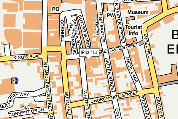
IP33 1LJ is located in the Abbeygate electoral ward, within the local authority district of West Suffolk and the English Parliamentary constituency of Bury St Edmunds. The Sub Integrated Care Board (ICB) Location is NHS Suffolk and North East Essex ICB - 07K and the police force is Suffolk. This postcode has been in use since January 1980.


GetTheData
Source: OS OpenMap – Local (Ordnance Survey)
Source: OS VectorMap District (Ordnance Survey)
Licence: Open Government Licence (requires attribution)
| Easting | 585333 |
| Northing | 264175 |
| Latitude | 52.244546 |
| Longitude | 0.713228 |
GetTheData
Source: Open Postcode Geo
Licence: Open Government Licence
| Country | England |
| Postcode District | IP33 |
➜ See where IP33 is on a map ➜ Where is Bury St Edmunds? | |
GetTheData
Source: Land Registry Price Paid Data
Licence: Open Government Licence
Elevation or altitude of IP33 1LJ as distance above sea level:
| Metres | Feet | |
|---|---|---|
| Elevation | 50m | 164ft |
Elevation is measured from the approximate centre of the postcode, to the nearest point on an OS contour line from OS Terrain 50, which has contour spacing of ten vertical metres.
➜ How high above sea level am I? Find the elevation of your current position using your device's GPS.
GetTheData
Source: Open Postcode Elevation
Licence: Open Government Licence
| Ward | Abbeygate |
| Constituency | Bury St Edmunds |
GetTheData
Source: ONS Postcode Database
Licence: Open Government Licence
| Arc Shopping Centre (St Andrews Street) | Bury St Edmunds | 183m |
| School (St Andrews Street South) | Bury St Edmunds | 192m |
| Arc Shopping Centre | Bury St Edmunds | 211m |
| Abbey Gardens (Angel Hill) | Bury St Edmunds | 221m |
| Abbey Gardens (Angel Hill) | Bury St Edmunds | 223m |
| Bury St Edmunds Station | 1km |
GetTheData
Source: NaPTAN
Licence: Open Government Licence
GetTheData
Source: ONS Postcode Database
Licence: Open Government Licence


➜ Get more ratings from the Food Standards Agency
GetTheData
Source: Food Standards Agency
Licence: FSA terms & conditions
| Last Collection | |||
|---|---|---|---|
| Location | Mon-Fri | Sat | Distance |
| 2 Butter Market | 18:00 | 11:30 | 36m |
| Market Cross | 18:00 | 12:30 | 168m |
| 29-30 Angel Hill | 17:30 | 11:30 | 208m |
GetTheData
Source: Dracos
Licence: Creative Commons Attribution-ShareAlike
The below table lists the International Territorial Level (ITL) codes (formerly Nomenclature of Territorial Units for Statistics (NUTS) codes) and Local Administrative Units (LAU) codes for IP33 1LJ:
| ITL 1 Code | Name |
|---|---|
| TLH | East |
| ITL 2 Code | Name |
| TLH1 | East Anglia |
| ITL 3 Code | Name |
| TLH14 | Suffolk CC |
| LAU 1 Code | Name |
| E07000245 | West Suffolk |
GetTheData
Source: ONS Postcode Directory
Licence: Open Government Licence
The below table lists the Census Output Area (OA), Lower Layer Super Output Area (LSOA), and Middle Layer Super Output Area (MSOA) for IP33 1LJ:
| Code | Name | |
|---|---|---|
| OA | E00153396 | |
| LSOA | E01030091 | St Edmundsbury 006A |
| MSOA | E02006278 | St Edmundsbury 006 |
GetTheData
Source: ONS Postcode Directory
Licence: Open Government Licence
| IP33 1LB | Abbeygate Street | 17m |
| IP33 1UL | Abbeygate Street | 30m |
| IP33 1LQ | Abbeygate Street | 34m |
| IP33 1NE | Langton Place | 65m |
| IP33 1NX | Whiting Street | 75m |
| IP33 1UN | Abbeygate Street | 77m |
| IP33 1DB | Butter Market | 94m |
| IP33 1BJ | The Traverse | 97m |
| IP33 1ES | High Baxter Street | 100m |
| IP33 1LZ | Hatter Street | 100m |
GetTheData
Source: Open Postcode Geo; Land Registry Price Paid Data
Licence: Open Government Licence