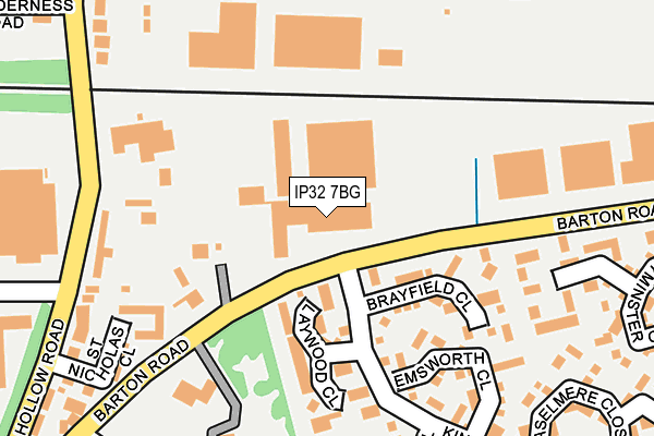
IP32 7BG is located in the Eastgate electoral ward, within the local authority district of West Suffolk and the English Parliamentary constituency of Bury St Edmunds. The Sub Integrated Care Board (ICB) Location is NHS Suffolk and North East Essex ICB - 07K and the police force is Suffolk. This postcode has been in use since January 1980.


GetTheData
Source: OS OpenMap – Local (Ordnance Survey)
Source: OS VectorMap District (Ordnance Survey)
Licence: Open Government Licence (requires attribution)
| Easting | 586641 |
| Northing | 265035 |
| Latitude | 52.251827 |
| Longitude | 0.732838 |
GetTheData
Source: Open Postcode Geo
Licence: Open Government Licence
| Country | England |
| Postcode District | IP32 |
➜ See where IP32 is on a map ➜ Where is Bury St Edmunds? | |
GetTheData
Source: Land Registry Price Paid Data
Licence: Open Government Licence
Elevation or altitude of IP32 7BG as distance above sea level:
| Metres | Feet | |
|---|---|---|
| Elevation | 50m | 164ft |
Elevation is measured from the approximate centre of the postcode, to the nearest point on an OS contour line from OS Terrain 50, which has contour spacing of ten vertical metres.
➜ How high above sea level am I? Find the elevation of your current position using your device's GPS.
GetTheData
Source: Open Postcode Elevation
Licence: Open Government Licence
| Ward | Eastgate |
| Constituency | Bury St Edmunds |
GetTheData
Source: ONS Postcode Database
Licence: Open Government Licence
| 24 Seven Industrial Estate (Barton Road) | Bury St Edmunds | 47m |
| 24 Seven Industrial Estate (Barton Road) | Bury St Edmunds | 55m |
| St Nicholas Close (Hollow Road) | Bury St Edmunds | 283m |
| St Nicholas Close (Hollow Road) | Bury St Edmunds | 294m |
| Holderness Road (Hollow Road) | Bury St Edmunds | 298m |
| Bury St Edmunds Station | 1.4km |
GetTheData
Source: NaPTAN
Licence: Open Government Licence
GetTheData
Source: ONS Postcode Database
Licence: Open Government Licence


➜ Get more ratings from the Food Standards Agency
GetTheData
Source: Food Standards Agency
Licence: FSA terms & conditions
| Last Collection | |||
|---|---|---|---|
| Location | Mon-Fri | Sat | Distance |
| Barton Road | 17:00 | 11:30 | 48m |
| 6 Hollow Road | 17:00 | 11:30 | 297m |
| Appledown Drive | 17:00 | 11:30 | 756m |
GetTheData
Source: Dracos
Licence: Creative Commons Attribution-ShareAlike
The below table lists the International Territorial Level (ITL) codes (formerly Nomenclature of Territorial Units for Statistics (NUTS) codes) and Local Administrative Units (LAU) codes for IP32 7BG:
| ITL 1 Code | Name |
|---|---|
| TLH | East |
| ITL 2 Code | Name |
| TLH1 | East Anglia |
| ITL 3 Code | Name |
| TLH14 | Suffolk CC |
| LAU 1 Code | Name |
| E07000245 | West Suffolk |
GetTheData
Source: ONS Postcode Directory
Licence: Open Government Licence
The below table lists the Census Output Area (OA), Lower Layer Super Output Area (LSOA), and Middle Layer Super Output Area (MSOA) for IP32 7BG:
| Code | Name | |
|---|---|---|
| OA | E00153458 | |
| LSOA | E01033048 | St Edmundsbury 009F |
| MSOA | E02006281 | St Edmundsbury 009 |
GetTheData
Source: ONS Postcode Directory
Licence: Open Government Licence
| IP32 7JD | Laywood Close | 113m |
| IP32 7EN | Brayfield Close | 129m |
| IP32 7BE | Barton Road | 165m |
| IP32 7LT | Emsworth Close | 189m |
| IP32 7AY | Hollow Road | 212m |
| IP32 7AX | St Nicholas Close | 220m |
| IP32 7JP | Greenways Crescent | 229m |
| IP32 7NH | Midhurst Close | 265m |
| IP32 7JB | Arundel Close | 292m |
| IP32 7JQ | Haselmere Close | 303m |
GetTheData
Source: Open Postcode Geo; Land Registry Price Paid Data
Licence: Open Government Licence