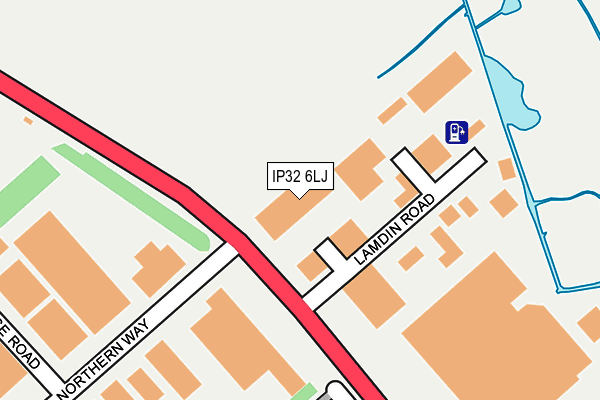
IP32 6LJ is located in the St Olaves electoral ward, within the local authority district of West Suffolk and the English Parliamentary constituency of Bury St Edmunds. The Sub Integrated Care Board (ICB) Location is NHS Suffolk and North East Essex ICB - 07K and the police force is Suffolk. This postcode has been in use since November 2007.


GetTheData
Source: OS OpenMap – Local (Ordnance Survey)
Source: OS VectorMap District (Ordnance Survey)
Licence: Open Government Licence (requires attribution)
| Easting | 584545 |
| Northing | 266845 |
| Latitude | 52.268788 |
| Longitude | 0.703158 |
GetTheData
Source: Open Postcode Geo
Licence: Open Government Licence
| Country | England |
| Postcode District | IP32 |
➜ See where IP32 is on a map ➜ Where is Bury St Edmunds? | |
GetTheData
Source: Land Registry Price Paid Data
Licence: Open Government Licence
Elevation or altitude of IP32 6LJ as distance above sea level:
| Metres | Feet | |
|---|---|---|
| Elevation | 30m | 98ft |
Elevation is measured from the approximate centre of the postcode, to the nearest point on an OS contour line from OS Terrain 50, which has contour spacing of ten vertical metres.
➜ How high above sea level am I? Find the elevation of your current position using your device's GPS.
GetTheData
Source: Open Postcode Elevation
Licence: Open Government Licence
| Ward | St Olaves |
| Constituency | Bury St Edmunds |
GetTheData
Source: ONS Postcode Database
Licence: Open Government Licence
| Lambdin Road | Bury St Edmunds | 94m |
| Lambdin Road | Bury St Edmunds | 102m |
| Lake Avenue (Severn Road) | Mildenhall Road Estate | 419m |
| Lake Avenue (Severn Road) | Mildenhall Road Estate | 421m |
| Acacia Avenue | Mildenhall Road Estate | 484m |
| Bury St Edmunds Station | 1.8km |
GetTheData
Source: NaPTAN
Licence: Open Government Licence
GetTheData
Source: ONS Postcode Database
Licence: Open Government Licence


➜ Get more ratings from the Food Standards Agency
GetTheData
Source: Food Standards Agency
Licence: FSA terms & conditions
| Last Collection | |||
|---|---|---|---|
| Location | Mon-Fri | Sat | Distance |
| Northern Way | 16:45 | 11:30 | 131m |
| Post Office, Sth Pde, Lake Ave | 17:00 | 11:30 | 587m |
| Post Office, St. Olaves Prcnt | 17:00 | 11:30 | 1,204m |
GetTheData
Source: Dracos
Licence: Creative Commons Attribution-ShareAlike
The below table lists the International Territorial Level (ITL) codes (formerly Nomenclature of Territorial Units for Statistics (NUTS) codes) and Local Administrative Units (LAU) codes for IP32 6LJ:
| ITL 1 Code | Name |
|---|---|
| TLH | East |
| ITL 2 Code | Name |
| TLH1 | East Anglia |
| ITL 3 Code | Name |
| TLH14 | Suffolk CC |
| LAU 1 Code | Name |
| E07000245 | West Suffolk |
GetTheData
Source: ONS Postcode Directory
Licence: Open Government Licence
The below table lists the Census Output Area (OA), Lower Layer Super Output Area (LSOA), and Middle Layer Super Output Area (MSOA) for IP32 6LJ:
| Code | Name | |
|---|---|---|
| OA | E00153460 | |
| LSOA | E01030103 | St Edmundsbury 004A |
| MSOA | E02006276 | St Edmundsbury 004 |
GetTheData
Source: ONS Postcode Directory
Licence: Open Government Licence
| IP32 6HH | Mitchell Avenue | 222m |
| IP32 6HJ | Trent Road | 260m |
| IP32 6HL | Acacia Avenue | 304m |
| IP32 6NL | Coppice End | 325m |
| IP32 6NG | Severn Road | 337m |
| IP32 6HF | Mitchell Avenue | 341m |
| IP32 6JX | Waveney Road | 362m |
| IP32 6HN | Acacia Avenue | 362m |
| IP32 6HE | Conway Road | 406m |
| IP32 6JU | Waveney Road | 409m |
GetTheData
Source: Open Postcode Geo; Land Registry Price Paid Data
Licence: Open Government Licence