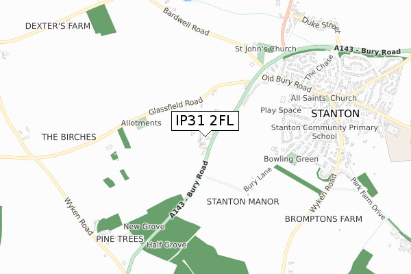
IP31 2FL is located in the Stanton electoral ward, within the local authority district of West Suffolk and the English Parliamentary constituency of West Suffolk. The Sub Integrated Care Board (ICB) Location is NHS Suffolk and North East Essex ICB - 07K and the police force is Suffolk. This postcode has been in use since August 2018.


GetTheData
Source: OS Open Zoomstack (Ordnance Survey)
Licence: Open Government Licence (requires attribution)
Attribution: Contains OS data © Crown copyright and database right 2025
Source: Open Postcode Geo
Licence: Open Government Licence (requires attribution)
Attribution: Contains OS data © Crown copyright and database right 2025; Contains Royal Mail data © Royal Mail copyright and database right 2025; Source: Office for National Statistics licensed under the Open Government Licence v.3.0
| Easting | 595878 |
| Northing | 273204 |
| Latitude | 52.321987 |
| Longitude | 0.872753 |
GetTheData
Source: Open Postcode Geo
Licence: Open Government Licence
| Country | England |
| Postcode District | IP31 |
➜ See where IP31 is on a map ➜ Where is Stanton? | |
GetTheData
Source: Land Registry Price Paid Data
Licence: Open Government Licence
| Ward | Stanton |
| Constituency | West Suffolk |
GetTheData
Source: ONS Postcode Database
Licence: Open Government Licence
1, ROSE & CROWN COURT, STANTON, BURY ST EDMUNDS, IP31 2FL 2024 1 FEB £500,000 |
THE BARN, 3, ROSE & CROWN COURT, STANTON, BURY ST EDMUNDS, IP31 2FL 2023 11 DEC £262,000 |
2, ROSE & CROWN COURT, STANTON, BURY ST EDMUNDS, IP31 2FL 2022 8 FEB £485,000 |
1, ROSE & CROWN COURT, STANTON, BURY ST EDMUNDS, IP31 2FL 2020 11 MAY £190,000 |
THE BARN, 3, ROSE & CROWN COURT, STANTON, BURY ST EDMUNDS, IP31 2FL 2019 19 SEP £250,000 |
10, ROSE & CROWN COURT, STANTON, BURY ST EDMUNDS, IP31 2FL 2019 22 AUG £460,000 |
9, ROSE & CROWN COURT, STANTON, BURY ST EDMUNDS, IP31 2FL 2019 11 JUN £480,000 |
9, ROSE & CROWN COURT, STANTON, BURY ST EDMUNDS, IP31 2FL 2018 22 AUG £193,500 |
1, ROSE & CROWN COURT, STANTON, BURY ST EDMUNDS, IP31 2FL 2017 15 SEP £200,000 |
GetTheData
Source: HM Land Registry Price Paid Data
Licence: Contains HM Land Registry data © Crown copyright and database right 2025. This data is licensed under the Open Government Licence v3.0.
| Coach Stop (Bury Road) | Stanton | 465m |
| Coach Stop (Bury Road) | Stanton | 504m |
| Jacobs Close (Old Bury Road) | Stanton | 516m |
| Jacobs Close (Old Bury Road) | Stanton | 579m |
| Memorial | Stanton | 789m |
GetTheData
Source: NaPTAN
Licence: Open Government Licence
| Percentage of properties with Next Generation Access | 100.0% |
| Percentage of properties with Superfast Broadband | 100.0% |
| Percentage of properties with Ultrafast Broadband | 0.0% |
| Percentage of properties with Full Fibre Broadband | 0.0% |
Superfast Broadband is between 30Mbps and 300Mbps
Ultrafast Broadband is > 300Mbps
| Percentage of properties unable to receive 2Mbps | 0.0% |
| Percentage of properties unable to receive 5Mbps | 0.0% |
| Percentage of properties unable to receive 10Mbps | 0.0% |
| Percentage of properties unable to receive 30Mbps | 0.0% |
GetTheData
Source: Ofcom
Licence: Ofcom Terms of Use (requires attribution)
GetTheData
Source: ONS Postcode Database
Licence: Open Government Licence


➜ Get more ratings from the Food Standards Agency
GetTheData
Source: Food Standards Agency
Licence: FSA terms & conditions
| Last Collection | |||
|---|---|---|---|
| Location | Mon-Fri | Sat | Distance |
| Post Office, Up Street | 16:30 | 11:45 | 1,604m |
| Shepherds Grove | 16:15 | 11:15 | 2,017m |
| Post Office, The Street | 16:00 | 10:00 | 3,119m |
GetTheData
Source: Dracos
Licence: Creative Commons Attribution-ShareAlike
The below table lists the International Territorial Level (ITL) codes (formerly Nomenclature of Territorial Units for Statistics (NUTS) codes) and Local Administrative Units (LAU) codes for IP31 2FL:
| ITL 1 Code | Name |
|---|---|
| TLH | East |
| ITL 2 Code | Name |
| TLH1 | East Anglia |
| ITL 3 Code | Name |
| TLH14 | Suffolk CC |
| LAU 1 Code | Name |
| E07000245 | West Suffolk |
GetTheData
Source: ONS Postcode Directory
Licence: Open Government Licence
The below table lists the Census Output Area (OA), Lower Layer Super Output Area (LSOA), and Middle Layer Super Output Area (MSOA) for IP31 2FL:
| Code | Name | |
|---|---|---|
| OA | E00153686 | |
| LSOA | E01030145 | St Edmundsbury 001D |
| MSOA | E02006273 | St Edmundsbury 001 |
GetTheData
Source: ONS Postcode Directory
Licence: Open Government Licence
| IP31 2DS | Glassfield Road | 288m |
| IP31 2BZ | Bury Road | 316m |
| IP31 2EE | Fordhams Close | 508m |
| IP31 2DF | Bury Lane | 524m |
| IP31 2JH | Old Rectory Gardens | 556m |
| IP31 2BX | Old Bury Road | 603m |
| IP31 2JR | Jacobs Close | 611m |
| IP31 2EA | Bardwell Road | 612m |
| IP31 2ED | Sturgeon Way | 615m |
| IP31 2XH | Shetlands | 641m |
GetTheData
Source: Open Postcode Geo; Land Registry Price Paid Data
Licence: Open Government Licence