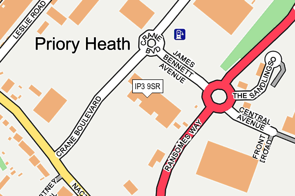
IP3 9SR is located in the Priory Heath electoral ward, within the local authority district of Ipswich and the English Parliamentary constituency of Ipswich. The Sub Integrated Care Board (ICB) Location is NHS Suffolk and North East Essex ICB - 06L and the police force is Suffolk. This postcode has been in use since August 2013.


GetTheData
Source: OS OpenMap – Local (Ordnance Survey)
Source: OS VectorMap District (Ordnance Survey)
Licence: Open Government Licence (requires attribution)
| Easting | 619742 |
| Northing | 241996 |
| Latitude | 52.032810 |
| Longitude | 1.202118 |
GetTheData
Source: Open Postcode Geo
Licence: Open Government Licence
| Country | England |
| Postcode District | IP3 |
➜ See where IP3 is on a map ➜ Where is Ipswich? | |
GetTheData
Source: Land Registry Price Paid Data
Licence: Open Government Licence
Elevation or altitude of IP3 9SR as distance above sea level:
| Metres | Feet | |
|---|---|---|
| Elevation | 40m | 131ft |
Elevation is measured from the approximate centre of the postcode, to the nearest point on an OS contour line from OS Terrain 50, which has contour spacing of ten vertical metres.
➜ How high above sea level am I? Find the elevation of your current position using your device's GPS.
GetTheData
Source: Open Postcode Elevation
Licence: Open Government Licence
| Ward | Priory Heath |
| Constituency | Ipswich |
GetTheData
Source: ONS Postcode Database
Licence: Open Government Licence
| Waitrose | Priory Heath | 84m |
| Waitrose | Priory Heath | 105m |
| The Thrasher (Ransomes Way) | Ransomes Europark | 205m |
| The Thrasher (Ransomes Way) | Ransomes Europark | 206m |
| Euro Retail Park (Ransomes Way) | Warren Heath | 211m |
| Derby Road (Ipswich) Station | 2.4km |
| Ipswich Station | 4.4km |
GetTheData
Source: NaPTAN
Licence: Open Government Licence
GetTheData
Source: ONS Postcode Database
Licence: Open Government Licence


➜ Get more ratings from the Food Standards Agency
GetTheData
Source: Food Standards Agency
Licence: FSA terms & conditions
| Last Collection | |||
|---|---|---|---|
| Location | Mon-Fri | Sat | Distance |
| Reynolds Road Post Office | 17:30 | 12:15 | 311m |
| Ip3 Bluestem Road Business Box | 18:30 | 312m | |
| Bluestem Road | 18:30 | 12:30 | 314m |
GetTheData
Source: Dracos
Licence: Creative Commons Attribution-ShareAlike
The below table lists the International Territorial Level (ITL) codes (formerly Nomenclature of Territorial Units for Statistics (NUTS) codes) and Local Administrative Units (LAU) codes for IP3 9SR:
| ITL 1 Code | Name |
|---|---|
| TLH | East |
| ITL 2 Code | Name |
| TLH1 | East Anglia |
| ITL 3 Code | Name |
| TLH14 | Suffolk CC |
| LAU 1 Code | Name |
| E07000202 | Ipswich |
GetTheData
Source: ONS Postcode Directory
Licence: Open Government Licence
The below table lists the Census Output Area (OA), Lower Layer Super Output Area (LSOA), and Middle Layer Super Output Area (MSOA) for IP3 9SR:
| Code | Name | |
|---|---|---|
| OA | E00170867 | |
| LSOA | E01033128 | Ipswich 014F |
| MSOA | E02006258 | Ipswich 014 |
GetTheData
Source: ONS Postcode Directory
Licence: Open Government Licence
| IP3 9SP | Ransomes Way | 120m |
| IP3 9QE | Nacton Road | 318m |
| IP3 9QJ | Hening Avenue | 331m |
| IP3 9QF | Witney Close | 359m |
| IP3 9SN | The Sandlings | 360m |
| IP3 9QR | The Drift | 374m |
| IP3 9QS | Nacton Road | 403m |
| IP3 9UE | Demoiselle Crescent | 423m |
| IP3 9GG | Ravenswood Avenue | 436m |
| IP3 9UB | Chaser Close | 440m |
GetTheData
Source: Open Postcode Geo; Land Registry Price Paid Data
Licence: Open Government Licence