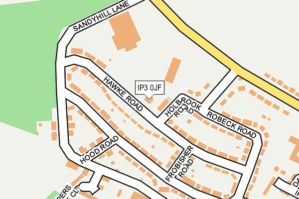
IP3 0JF is located in the Gainsborough electoral ward, within the local authority district of Ipswich and the English Parliamentary constituency of Ipswich. The Sub Integrated Care Board (ICB) Location is NHS Suffolk and North East Essex ICB - 06L and the police force is Suffolk. This postcode has been in use since January 1980.


GetTheData
Source: OS OpenMap – Local (Ordnance Survey)
Source: OS VectorMap District (Ordnance Survey)
Licence: Open Government Licence (requires attribution)
| Easting | 617422 |
| Northing | 242432 |
| Latitude | 52.037638 |
| Longitude | 1.168629 |
GetTheData
Source: Open Postcode Geo
Licence: Open Government Licence
| Country | England |
| Postcode District | IP3 |
➜ See where IP3 is on a map | |
GetTheData
Source: Land Registry Price Paid Data
Licence: Open Government Licence
Elevation or altitude of IP3 0JF as distance above sea level:
| Metres | Feet | |
|---|---|---|
| Elevation | 30m | 98ft |
Elevation is measured from the approximate centre of the postcode, to the nearest point on an OS contour line from OS Terrain 50, which has contour spacing of ten vertical metres.
➜ How high above sea level am I? Find the elevation of your current position using your device's GPS.
GetTheData
Source: Open Postcode Elevation
Licence: Open Government Licence
| Ward | Gainsborough |
| Constituency | Ipswich |
GetTheData
Source: ONS Postcode Database
Licence: Open Government Licence
| Robeck Road | Greenwich | 102m |
| Bus Shelter (Holbrook Road) | Greenwich | 128m |
| Shops (Frobisher Road) | Greenwich | 137m |
| Listers (Sandyhill Lane) | Greenwich | 190m |
| Holbrook Road (Landseer Road) | Greenwich | 196m |
| Derby Road (Ipswich) Station | 1.7km |
| Ipswich Station | 2.2km |
| Westerfield Station | 4.8km |
GetTheData
Source: NaPTAN
Licence: Open Government Licence
GetTheData
Source: ONS Postcode Database
Licence: Open Government Licence


➜ Get more ratings from the Food Standards Agency
GetTheData
Source: Food Standards Agency
Licence: FSA terms & conditions
| Last Collection | |||
|---|---|---|---|
| Location | Mon-Fri | Sat | Distance |
| Cliff Lane Post Office | 18:30 | 11:45 | 807m |
| 80 Severn Road | 17:30 | 12:00 | 865m |
| Felixstowe Road Post Office | 17:30 | 12:15 | 1,031m |
GetTheData
Source: Dracos
Licence: Creative Commons Attribution-ShareAlike
The below table lists the International Territorial Level (ITL) codes (formerly Nomenclature of Territorial Units for Statistics (NUTS) codes) and Local Administrative Units (LAU) codes for IP3 0JF:
| ITL 1 Code | Name |
|---|---|
| TLH | East |
| ITL 2 Code | Name |
| TLH1 | East Anglia |
| ITL 3 Code | Name |
| TLH14 | Suffolk CC |
| LAU 1 Code | Name |
| E07000202 | Ipswich |
GetTheData
Source: ONS Postcode Directory
Licence: Open Government Licence
The below table lists the Census Output Area (OA), Lower Layer Super Output Area (LSOA), and Middle Layer Super Output Area (MSOA) for IP3 0JF:
| Code | Name | |
|---|---|---|
| OA | E00152796 | |
| LSOA | E01029980 | Ipswich 016C |
| MSOA | E02006260 | Ipswich 016 |
GetTheData
Source: ONS Postcode Directory
Licence: Open Government Licence
| IP3 0JD | Hawke Road | 94m |
| IP3 0HT | Robeck Road | 105m |
| IP3 0HU | Robeck Road | 106m |
| IP3 0HL | Holbrook Road | 147m |
| IP3 0HR | Frobisher Road | 151m |
| IP3 0JB | Sandy Hill Lane | 170m |
| IP3 0HW | Hawke Road | 177m |
| IP3 0HN | Robeck Road | 195m |
| IP3 0JA | Sandy Hill Lane | 210m |
| IP3 0NL | Pipers Vale Close | 231m |
GetTheData
Source: Open Postcode Geo; Land Registry Price Paid Data
Licence: Open Government Licence