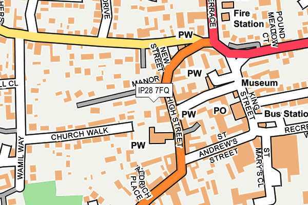
IP28 7FQ is located in the Mildenhall Kingsway & Market electoral ward, within the local authority district of West Suffolk and the English Parliamentary constituency of West Suffolk. The Sub Integrated Care Board (ICB) Location is NHS Suffolk and North East Essex ICB - 07K and the police force is Suffolk. This postcode has been in use since June 2017.


GetTheData
Source: OS OpenMap – Local (Ordnance Survey)
Source: OS VectorMap District (Ordnance Survey)
Licence: Open Government Licence (requires attribution)
| Easting | 571022 |
| Northing | 274667 |
| Latitude | 52.343427 |
| Longitude | 0.509184 |
GetTheData
Source: Open Postcode Geo
Licence: Open Government Licence
| Country | England |
| Postcode District | IP28 |
➜ See where IP28 is on a map ➜ Where is Mildenhall? | |
GetTheData
Source: Land Registry Price Paid Data
Licence: Open Government Licence
| Ward | Mildenhall Kingsway & Market |
| Constituency | West Suffolk |
GetTheData
Source: ONS Postcode Database
Licence: Open Government Licence
| St Marys Church (High Street) | Mildenhall | 95m |
| St Marys Church (High Street) | Mildenhall | 104m |
| Queensway | Mildenhall | 143m |
| Queensway | Mildenhall | 148m |
| Folly Road (North Terrace) | Mildenhall | 419m |
GetTheData
Source: NaPTAN
Licence: Open Government Licence
| Percentage of properties with Next Generation Access | 100.0% |
| Percentage of properties with Superfast Broadband | 100.0% |
| Percentage of properties with Ultrafast Broadband | 10.0% |
| Percentage of properties with Full Fibre Broadband | 0.0% |
Superfast Broadband is between 30Mbps and 300Mbps
Ultrafast Broadband is > 300Mbps
| Median download speed | 39.5Mbps |
| Average download speed | 49.9Mbps |
| Maximum download speed | 117.49Mbps |
| Median upload speed | 9.9Mbps |
| Average upload speed | 8.6Mbps |
| Maximum upload speed | 19.53Mbps |
| Percentage of properties unable to receive 2Mbps | 0.0% |
| Percentage of properties unable to receive 5Mbps | 0.0% |
| Percentage of properties unable to receive 10Mbps | 0.0% |
| Percentage of properties unable to receive 30Mbps | 0.0% |
GetTheData
Source: Ofcom
Licence: Ofcom Terms of Use (requires attribution)
GetTheData
Source: ONS Postcode Database
Licence: Open Government Licence


➜ Get more ratings from the Food Standards Agency
GetTheData
Source: Food Standards Agency
Licence: FSA terms & conditions
| Last Collection | |||
|---|---|---|---|
| Location | Mon-Fri | Sat | Distance |
| Post Office, Mill Street | 17:30 | 12:00 | 168m |
| King Street | 17:00 | 10:00 | 185m |
| Queensway | 11:30 | 11:30 | 280m |
GetTheData
Source: Dracos
Licence: Creative Commons Attribution-ShareAlike
The below table lists the International Territorial Level (ITL) codes (formerly Nomenclature of Territorial Units for Statistics (NUTS) codes) and Local Administrative Units (LAU) codes for IP28 7FQ:
| ITL 1 Code | Name |
|---|---|
| TLH | East |
| ITL 2 Code | Name |
| TLH1 | East Anglia |
| ITL 3 Code | Name |
| TLH14 | Suffolk CC |
| LAU 1 Code | Name |
| E07000245 | West Suffolk |
GetTheData
Source: ONS Postcode Directory
Licence: Open Government Licence
The below table lists the Census Output Area (OA), Lower Layer Super Output Area (LSOA), and Middle Layer Super Output Area (MSOA) for IP28 7FQ:
| Code | Name | |
|---|---|---|
| OA | E00152625 | |
| LSOA | E01029947 | Forest Heath 004E |
| MSOA | E02006241 | Forest Heath 004 |
GetTheData
Source: ONS Postcode Directory
Licence: Open Government Licence
| IP28 7EQ | High Street | 26m |
| IP28 7EH | Manor Court | 82m |
| IP28 7EN | New Street | 86m |
| IP28 7EL | Manor Road | 92m |
| IP28 7EF | Market Place | 97m |
| IP28 7EP | Queensway | 102m |
| IP28 7EE | Churchyard | 119m |
| IP28 7EA | High Street | 121m |
| IP28 7EJ | High Street | 123m |
| IP28 7ET | The Shrublands | 125m |
GetTheData
Source: Open Postcode Geo; Land Registry Price Paid Data
Licence: Open Government Licence