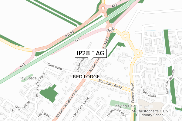
IP28 1AG is located in the Iceni electoral ward, within the local authority district of West Suffolk and the English Parliamentary constituency of West Suffolk. The Sub Integrated Care Board (ICB) Location is NHS Suffolk and North East Essex ICB - 07K and the police force is Suffolk. This postcode has been in use since September 2019.


GetTheData
Source: OS Open Zoomstack (Ordnance Survey)
Licence: Open Government Licence (requires attribution)
Attribution: Contains OS data © Crown copyright and database right 2025
Source: Open Postcode Geo
Licence: Open Government Licence (requires attribution)
Attribution: Contains OS data © Crown copyright and database right 2025; Contains Royal Mail data © Royal Mail copyright and database right 2025; Source: Office for National Statistics licensed under the Open Government Licence v.3.0
| Easting | 569999 |
| Northing | 270811 |
| Latitude | 52.309111 |
| Longitude | 0.492235 |
GetTheData
Source: Open Postcode Geo
Licence: Open Government Licence
| Country | England |
| Postcode District | IP28 |
➜ See where IP28 is on a map ➜ Where is Red Lodge? | |
GetTheData
Source: Land Registry Price Paid Data
Licence: Open Government Licence
| Ward | Iceni |
| Constituency | West Suffolk |
GetTheData
Source: ONS Postcode Database
Licence: Open Government Licence
| Horseshoe Drive (Boundary Road) | Red Lodge | 118m |
| Horseshoe Drive (Boundary Road) | Red Lodge | 127m |
| Heathersett Way (Warren Road) | Red Lodge | 390m |
| Heathersett Way (Warren Road) | Red Lodge | 402m |
| Blackberry Way (Heatherset Way) | Red Lodge | 407m |
| Kennett Station | 3.5km |
GetTheData
Source: NaPTAN
Licence: Open Government Licence
GetTheData
Source: ONS Postcode Database
Licence: Open Government Licence


➜ Get more ratings from the Food Standards Agency
GetTheData
Source: Food Standards Agency
Licence: FSA terms & conditions
| Last Collection | |||
|---|---|---|---|
| Location | Mon-Fri | Sat | Distance |
| Boundary Road | 11:00 | 11:00 | 267m |
| Ip28 Hundred Acre Way | 16:00 | 10:30 | 568m |
| Post Office, Bennet Road | 16:30 | 08:30 | 593m |
GetTheData
Source: Dracos
Licence: Creative Commons Attribution-ShareAlike
The below table lists the International Territorial Level (ITL) codes (formerly Nomenclature of Territorial Units for Statistics (NUTS) codes) and Local Administrative Units (LAU) codes for IP28 1AG:
| ITL 1 Code | Name |
|---|---|
| TLH | East |
| ITL 2 Code | Name |
| TLH1 | East Anglia |
| ITL 3 Code | Name |
| TLH14 | Suffolk CC |
| LAU 1 Code | Name |
| E07000245 | West Suffolk |
GetTheData
Source: ONS Postcode Directory
Licence: Open Government Licence
The below table lists the Census Output Area (OA), Lower Layer Super Output Area (LSOA), and Middle Layer Super Output Area (MSOA) for IP28 1AG:
| Code | Name | |
|---|---|---|
| OA | E00152615 | |
| LSOA | E01029945 | Forest Heath 003E |
| MSOA | E02006240 | Forest Heath 003 |
GetTheData
Source: ONS Postcode Directory
Licence: Open Government Licence
| IP28 8GH | Scots Pine Court | 51m |
| IP28 8ER | Horseshoe Drive | 84m |
| IP28 8TD | Elms Road | 153m |
| IP28 8JQ | Boundary Road | 176m |
| IP28 8JH | Warren Road | 188m |
| IP28 8HJ | Pine Court | 190m |
| IP28 8XA | Olive Way | 243m |
| IP28 8TB | Clover Way | 274m |
| IP28 8JL | Larkspur Close | 308m |
| IP28 8TS | Hollyhock Walk | 309m |
GetTheData
Source: Open Postcode Geo; Land Registry Price Paid Data
Licence: Open Government Licence