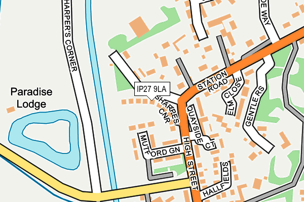
IP27 9LA is located in the Lakenheath electoral ward, within the local authority district of West Suffolk and the English Parliamentary constituency of West Suffolk. The Sub Integrated Care Board (ICB) Location is NHS Suffolk and North East Essex ICB - 07K and the police force is Suffolk. This postcode has been in use since July 2017.


GetTheData
Source: OS OpenMap – Local (Ordnance Survey)
Source: OS VectorMap District (Ordnance Survey)
Licence: Open Government Licence (requires attribution)
| Easting | 571127 |
| Northing | 283365 |
| Latitude | 52.421516 |
| Longitude | 0.515159 |
GetTheData
Source: Open Postcode Geo
Licence: Open Government Licence
| Country | England |
| Postcode District | IP27 |
➜ See where IP27 is on a map ➜ Where is Lakenheath? | |
GetTheData
Source: Land Registry Price Paid Data
Licence: Open Government Licence
| Ward | Lakenheath |
| Constituency | West Suffolk |
GetTheData
Source: ONS Postcode Database
Licence: Open Government Licence
| Quayside Court (High Street) | Lakenheath | 85m |
| Quayside Court (High Street) | Lakenheath | 94m |
| Briscoe Way (Station Road) | Lakenheath | 208m |
| Elm Close (Station Road) | Lakenheath | 209m |
| Post Box (Woodlands) | Lakenheath | 495m |
| Lakenheath Station | 3.2km |
GetTheData
Source: NaPTAN
Licence: Open Government Licence
| Percentage of properties with Next Generation Access | 100.0% |
| Percentage of properties with Superfast Broadband | 100.0% |
| Percentage of properties with Ultrafast Broadband | 0.0% |
| Percentage of properties with Full Fibre Broadband | 0.0% |
Superfast Broadband is between 30Mbps and 300Mbps
Ultrafast Broadband is > 300Mbps
| Median download speed | 66.1Mbps |
| Average download speed | 58.2Mbps |
| Maximum download speed | 80.00Mbps |
| Median upload speed | 14.8Mbps |
| Average upload speed | 13.8Mbps |
| Maximum upload speed | 20.00Mbps |
| Percentage of properties unable to receive 2Mbps | 0.0% |
| Percentage of properties unable to receive 5Mbps | 0.0% |
| Percentage of properties unable to receive 10Mbps | 0.0% |
| Percentage of properties unable to receive 30Mbps | 0.0% |
GetTheData
Source: Ofcom
Licence: Ofcom Terms of Use (requires attribution)
Estimated total energy consumption in IP27 9LA by fuel type, 2015.
| Consumption (kWh) | 9,980 |
|---|---|
| Meter count | 6 |
| Mean (kWh/meter) | 1,663 |
| Median (kWh/meter) | 395 |
GetTheData
Source: Postcode level gas estimates: 2015 (experimental)
Source: Postcode level electricity estimates: 2015 (experimental)
Licence: Open Government Licence
GetTheData
Source: ONS Postcode Database
Licence: Open Government Licence


➜ Get more ratings from the Food Standards Agency
GetTheData
Source: Food Standards Agency
Licence: FSA terms & conditions
| Last Collection | |||
|---|---|---|---|
| Location | Mon-Fri | Sat | Distance |
| Woodlands Way | 16:00 | 09:30 | 495m |
| Post Office, High Street | 16:10 | 09:30 | 535m |
| Wingfield Road | 16:00 | 09:30 | 621m |
GetTheData
Source: Dracos
Licence: Creative Commons Attribution-ShareAlike
The below table lists the International Territorial Level (ITL) codes (formerly Nomenclature of Territorial Units for Statistics (NUTS) codes) and Local Administrative Units (LAU) codes for IP27 9LA:
| ITL 1 Code | Name |
|---|---|
| TLH | East |
| ITL 2 Code | Name |
| TLH1 | East Anglia |
| ITL 3 Code | Name |
| TLH14 | Suffolk CC |
| LAU 1 Code | Name |
| E07000245 | West Suffolk |
GetTheData
Source: ONS Postcode Directory
Licence: Open Government Licence
The below table lists the Census Output Area (OA), Lower Layer Super Output Area (LSOA), and Middle Layer Super Output Area (MSOA) for IP27 9LA:
| Code | Name | |
|---|---|---|
| OA | E00152602 | |
| LSOA | E01033453 | Forest Heath 002F |
| MSOA | E02006239 | Forest Heath 002 |
GetTheData
Source: ONS Postcode Directory
Licence: Open Government Licence
| IP27 9LR | Mutford Green | 83m |
| IP27 9LB | Sharpes Corner | 102m |
| IP27 9JA | Station Road | 151m |
| IP27 9JH | Elm Close | 172m |
| IP27 9FT | Kitchener Close | 201m |
| IP27 9LP | Hall Fields | 204m |
| IP27 9SB | Jubilee Road | 227m |
| IP27 9JX | High Street | 266m |
| IP27 9JT | Hall Drive | 266m |
| IP27 9SD | Burrow Drive | 270m |
GetTheData
Source: Open Postcode Geo; Land Registry Price Paid Data
Licence: Open Government Licence