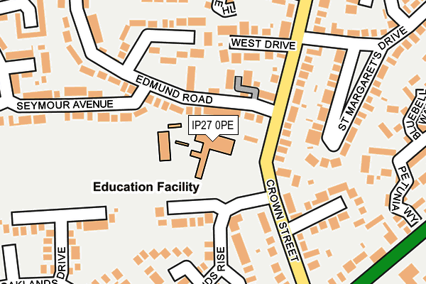
IP27 0PE is located in the Brandon West electoral ward, within the local authority district of West Suffolk and the English Parliamentary constituency of West Suffolk. The Sub Integrated Care Board (ICB) Location is NHS Suffolk and North East Essex ICB - 07K and the police force is Suffolk. This postcode has been in use since August 2012.


GetTheData
Source: OS OpenMap – Local (Ordnance Survey)
Source: OS VectorMap District (Ordnance Survey)
Licence: Open Government Licence (requires attribution)
| Easting | 577016 |
| Northing | 285690 |
| Latitude | 52.440506 |
| Longitude | 0.602872 |
GetTheData
Source: Open Postcode Geo
Licence: Open Government Licence
| Country | England |
| Postcode District | IP27 |
➜ See where IP27 is on a map ➜ Where is Brandon? | |
GetTheData
Source: Land Registry Price Paid Data
Licence: Open Government Licence
Elevation or altitude of IP27 0PE as distance above sea level:
| Metres | Feet | |
|---|---|---|
| Elevation | 10m | 33ft |
Elevation is measured from the approximate centre of the postcode, to the nearest point on an OS contour line from OS Terrain 50, which has contour spacing of ten vertical metres.
➜ How high above sea level am I? Find the elevation of your current position using your device's GPS.
GetTheData
Source: Open Postcode Elevation
Licence: Open Government Licence
| Ward | Brandon West |
| Constituency | West Suffolk |
GetTheData
Source: ONS Postcode Database
Licence: Open Government Licence
| Breckland Middle School (Woodlands Rise) | Brandon | 105m |
| Breckland Middle School (Woodlands Rise) | Brandon | 107m |
| Edmund Road | Brandon | 140m |
| Edmund Road | Brandon | 154m |
| Mile End (Crown Street) | Brandon | 212m |
| Brandon Station | 2.1km |
| Lakenheath Station | 4.7km |
GetTheData
Source: NaPTAN
Licence: Open Government Licence
GetTheData
Source: ONS Postcode Database
Licence: Open Government Licence


➜ Get more ratings from the Food Standards Agency
GetTheData
Source: Food Standards Agency
Licence: FSA terms & conditions
| Last Collection | |||
|---|---|---|---|
| Location | Mon-Fri | Sat | Distance |
| Post Office, Town Street | 16:35 | 11:00 | 252m |
| Industrial Estate, Highbury Road | 16:30 | 11:00 | 445m |
| Mile End | 16:45 | 11:00 | 459m |
GetTheData
Source: Dracos
Licence: Creative Commons Attribution-ShareAlike
The below table lists the International Territorial Level (ITL) codes (formerly Nomenclature of Territorial Units for Statistics (NUTS) codes) and Local Administrative Units (LAU) codes for IP27 0PE:
| ITL 1 Code | Name |
|---|---|
| TLH | East |
| ITL 2 Code | Name |
| TLH1 | East Anglia |
| ITL 3 Code | Name |
| TLH14 | Suffolk CC |
| LAU 1 Code | Name |
| E07000245 | West Suffolk |
GetTheData
Source: ONS Postcode Directory
Licence: Open Government Licence
The below table lists the Census Output Area (OA), Lower Layer Super Output Area (LSOA), and Middle Layer Super Output Area (MSOA) for IP27 0PE:
| Code | Name | |
|---|---|---|
| OA | E00152540 | |
| LSOA | E01029929 | Forest Heath 001D |
| MSOA | E02006238 | Forest Heath 001 |
GetTheData
Source: ONS Postcode Directory
Licence: Open Government Licence
| IP27 0JR | Crown Street | 123m |
| IP27 0XA | Edmund Road | 129m |
| IP27 0JS | West Drive | 162m |
| IP27 0NT | Woodlands Rise | 163m |
| IP27 0NH | Crown Street | 188m |
| IP27 0XD | Edmund Road | 198m |
| IP27 0NU | Woodlands Rise | 200m |
| IP27 0JX | Pond Lane | 218m |
| IP27 0JY | The Drove | 219m |
| IP27 0JT | Crown Street | 225m |
GetTheData
Source: Open Postcode Geo; Land Registry Price Paid Data
Licence: Open Government Licence