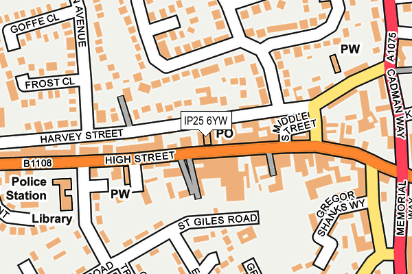
IP25 6YW is located in the Watton electoral ward, within the local authority district of Breckland and the English Parliamentary constituency of Mid Norfolk. The Sub Integrated Care Board (ICB) Location is NHS Norfolk and Waveney ICB - 26A and the police force is Norfolk. This postcode has been in use since July 2022.


GetTheData
Source: OS OpenMap – Local (Ordnance Survey)
Source: OS VectorMap District (Ordnance Survey)
Licence: Open Government Licence (requires attribution)
| Easting | 593395 |
| Northing | 300939 |
| Latitude | 52.571901 |
| Longitude | 0.852412 |
GetTheData
Source: Open Postcode Geo
Licence: Open Government Licence
| Country | England |
| Postcode District | IP25 |
➜ See where IP25 is on a map ➜ Where is Watton? | |
GetTheData
Source: Land Registry Price Paid Data
Licence: Open Government Licence
| Ward | Watton |
| Constituency | Mid Norfolk |
GetTheData
Source: ONS Postcode Database
Licence: Open Government Licence
2, SHETLAND DRIVE, WATTON, THETFORD, IP25 6YW 2023 1 DEC £380,000 |
8, SHETLAND DRIVE, WATTON, THETFORD, IP25 6YW 2023 20 JUL £370,000 |
10, SHETLAND DRIVE, WATTON, THETFORD, IP25 6YW 2023 30 JUN £370,000 |
23, SHETLAND DRIVE, WATTON, THETFORD, IP25 6YW 2022 9 DEC £315,000 |
21, SHETLAND DRIVE, WATTON, THETFORD, IP25 6YW 2022 1 DEC £320,000 |
1, SHETLAND DRIVE, WATTON, THETFORD, IP25 6YW 2022 8 NOV £350,000 |
3, SHETLAND DRIVE, WATTON, THETFORD, IP25 6YW 2022 30 SEP £365,000 |
GetTheData
Source: HM Land Registry Price Paid Data
Licence: Contains HM Land Registry data © Crown copyright and database right 2025. This data is licensed under the Open Government Licence v3.0.
| Portal Avenue (Norwich Road) | Watton | 169m |
| Camp Main Gate (Norwich Road) | Watton | 228m |
| Portal Avenue (Norwich Road) | Watton | 246m |
| Camp Main Gate (Norwich Road) | Watton | 342m |
| Lovell Gardens (Norwich Road) | Watton | 503m |
GetTheData
Source: NaPTAN
Licence: Open Government Licence
GetTheData
Source: ONS Postcode Database
Licence: Open Government Licence


➜ Get more ratings from the Food Standards Agency
GetTheData
Source: Food Standards Agency
Licence: FSA terms & conditions
| Last Collection | |||
|---|---|---|---|
| Location | Mon-Fri | Sat | Distance |
| Watton Green | 16:30 | 09:00 | 381m |
| Lovell Gardfens | 16:45 | 10:15 | 424m |
| Post Office, Norwich Road | 16:45 | 11:30 | 506m |
GetTheData
Source: Dracos
Licence: Creative Commons Attribution-ShareAlike
The below table lists the International Territorial Level (ITL) codes (formerly Nomenclature of Territorial Units for Statistics (NUTS) codes) and Local Administrative Units (LAU) codes for IP25 6YW:
| ITL 1 Code | Name |
|---|---|
| TLH | East |
| ITL 2 Code | Name |
| TLH1 | East Anglia |
| ITL 3 Code | Name |
| TLH17 | Breckland and South Norfolk |
| LAU 1 Code | Name |
| E07000143 | Breckland |
GetTheData
Source: ONS Postcode Directory
Licence: Open Government Licence
The below table lists the Census Output Area (OA), Lower Layer Super Output Area (LSOA), and Middle Layer Super Output Area (MSOA) for IP25 6YW:
| Code | Name | |
|---|---|---|
| OA | E00134605 | |
| LSOA | E01026487 | Breckland 009B |
| MSOA | E02005511 | Breckland 009 |
GetTheData
Source: ONS Postcode Directory
Licence: Open Government Licence
| IP25 6GU | Tom Turley Close | 135m |
| IP25 6HZ | Akrotiri Square | 161m |
| IP25 6JA | Changi Road | 171m |
| IP25 6HY | Akrotiri Square | 200m |
| IP25 6HR | Trenchard Crescent | 243m |
| IP25 6YF | Horseshoe Close | 263m |
| IP25 6RB | Watton Green | 279m |
| IP25 6GT | York Close | 287m |
| IP25 6YB | Shire Horse Way | 293m |
| IP25 6YD | Paddock Close | 293m |
GetTheData
Source: Open Postcode Geo; Land Registry Price Paid Data
Licence: Open Government Licence