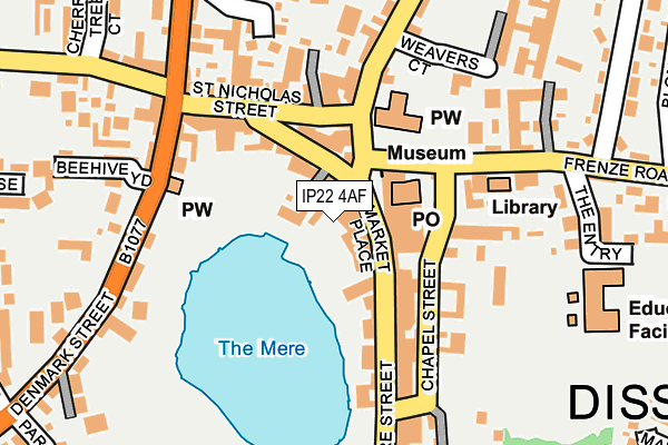
IP22 4AF lies on Hales Yard in Diss. IP22 4AF is located in the Diss & Roydon electoral ward, within the local authority district of South Norfolk and the English Parliamentary constituency of South Norfolk. The Sub Integrated Care Board (ICB) Location is NHS Norfolk and Waveney ICB - 26A and the police force is Norfolk. This postcode has been in use since December 1999.


GetTheData
Source: OS OpenMap – Local (Ordnance Survey)
Source: OS VectorMap District (Ordnance Survey)
Licence: Open Government Licence (requires attribution)
| Easting | 611673 |
| Northing | 279928 |
| Latitude | 52.376491 |
| Longitude | 1.108391 |
GetTheData
Source: Open Postcode Geo
Licence: Open Government Licence
| Street | Hales Yard |
| Town/City | Diss |
| Country | England |
| Postcode District | IP22 |
➜ See where IP22 is on a map ➜ Where is Diss? | |
GetTheData
Source: Land Registry Price Paid Data
Licence: Open Government Licence
Elevation or altitude of IP22 4AF as distance above sea level:
| Metres | Feet | |
|---|---|---|
| Elevation | 30m | 98ft |
Elevation is measured from the approximate centre of the postcode, to the nearest point on an OS contour line from OS Terrain 50, which has contour spacing of ten vertical metres.
➜ How high above sea level am I? Find the elevation of your current position using your device's GPS.
GetTheData
Source: Open Postcode Elevation
Licence: Open Government Licence
| Ward | Diss & Roydon |
| Constituency | South Norfolk |
GetTheData
Source: ONS Postcode Database
Licence: Open Government Licence
4, HALES YARD, DISS, IP22 4AF 2006 20 DEC £325,000 |
GetTheData
Source: HM Land Registry Price Paid Data
Licence: Contains HM Land Registry data © Crown copyright and database right 2025. This data is licensed under the Open Government Licence v3.0.
| Roydon Road (Denmark Street) | Diss | 158m |
| Roydon Road (Denmark Street) | Diss | 177m |
| Weavers Court (Mount Street) | Diss | 206m |
| Weavers Court (Mount Street) | Diss | 295m |
| Bus Station (Park Road) | Diss | 309m |
| Diss Station | 1.1km |
GetTheData
Source: NaPTAN
Licence: Open Government Licence
GetTheData
Source: ONS Postcode Database
Licence: Open Government Licence


➜ Get more ratings from the Food Standards Agency
GetTheData
Source: Food Standards Agency
Licence: FSA terms & conditions
| Last Collection | |||
|---|---|---|---|
| Location | Mon-Fri | Sat | Distance |
| Royal Mail, Market Place | 18:00 | 12:15 | 61m |
| Mere Street | 17:30 | 10:30 | 170m |
| Roydon Road | 17:30 | 11:00 | 213m |
GetTheData
Source: Dracos
Licence: Creative Commons Attribution-ShareAlike
The below table lists the International Territorial Level (ITL) codes (formerly Nomenclature of Territorial Units for Statistics (NUTS) codes) and Local Administrative Units (LAU) codes for IP22 4AF:
| ITL 1 Code | Name |
|---|---|
| TLH | East |
| ITL 2 Code | Name |
| TLH1 | East Anglia |
| ITL 3 Code | Name |
| TLH17 | Breckland and South Norfolk |
| LAU 1 Code | Name |
| E07000149 | South Norfolk |
GetTheData
Source: ONS Postcode Directory
Licence: Open Government Licence
The below table lists the Census Output Area (OA), Lower Layer Super Output Area (LSOA), and Middle Layer Super Output Area (MSOA) for IP22 4AF:
| Code | Name | |
|---|---|---|
| OA | E00136758 | |
| LSOA | E01026891 | South Norfolk 015D |
| MSOA | E02005611 | South Norfolk 015 |
GetTheData
Source: ONS Postcode Directory
Licence: Open Government Licence
| IP22 4AB | Market Place | 18m |
| IP22 4LL | Mallard Court | 38m |
| IP22 4JZ | Market Hill | 70m |
| IP22 4JT | Market Place | 72m |
| IP22 4LB | St Nicholas Street | 126m |
| IP22 4AN | Chapel Street | 138m |
| IP22 4AG | Mere Street | 147m |
| IP22 4DD | Church Street | 151m |
| IP22 4AD | Mere Street | 169m |
| IP22 4LQ | Beehive Yard | 190m |
GetTheData
Source: Open Postcode Geo; Land Registry Price Paid Data
Licence: Open Government Licence