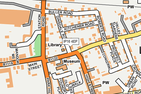
IP16 4EP is located in the Aldeburgh & Leiston electoral ward, within the local authority district of East Suffolk and the English Parliamentary constituency of Suffolk Coastal. The Sub Integrated Care Board (ICB) Location is NHS Suffolk and North East Essex ICB - 06L and the police force is Suffolk. This postcode has been in use since January 1980.


GetTheData
Source: OS OpenMap – Local (Ordnance Survey)
Source: OS VectorMap District (Ordnance Survey)
Licence: Open Government Licence (requires attribution)
| Easting | 644434 |
| Northing | 262684 |
| Latitude | 52.208123 |
| Longitude | 1.576221 |
GetTheData
Source: Open Postcode Geo
Licence: Open Government Licence
| Country | England |
| Postcode District | IP16 |
➜ See where IP16 is on a map ➜ Where is Leiston? | |
GetTheData
Source: Land Registry Price Paid Data
Licence: Open Government Licence
Elevation or altitude of IP16 4EP as distance above sea level:
| Metres | Feet | |
|---|---|---|
| Elevation | 10m | 33ft |
Elevation is measured from the approximate centre of the postcode, to the nearest point on an OS contour line from OS Terrain 50, which has contour spacing of ten vertical metres.
➜ How high above sea level am I? Find the elevation of your current position using your device's GPS.
GetTheData
Source: Open Postcode Elevation
Licence: Open Government Licence
| Ward | Aldeburgh & Leiston |
| Constituency | Suffolk Coastal |
GetTheData
Source: ONS Postcode Database
Licence: Open Government Licence
| Library (Main Street) | Leiston | 24m |
| Library (Main Street) | Leiston | 36m |
| Alde Valley Sixth Form (Waterloo Avenue) | Leiston | 291m |
| Alde Valley Sixth Form (Waterloo Avenue) | Leiston | 333m |
| Car Park (High Street) | Leiston | 349m |
GetTheData
Source: NaPTAN
Licence: Open Government Licence
GetTheData
Source: ONS Postcode Database
Licence: Open Government Licence


➜ Get more ratings from the Food Standards Agency
GetTheData
Source: Food Standards Agency
Licence: FSA terms & conditions
| Last Collection | |||
|---|---|---|---|
| Location | Mon-Fri | Sat | Distance |
| Abbey Road | 10:00 | 10:00 | 910m |
| 1 Mill Hill | 10:00 | 10:00 | 1,713m |
| Coldfair Green | 15:30 | 07:30 | 1,866m |
GetTheData
Source: Dracos
Licence: Creative Commons Attribution-ShareAlike
The below table lists the International Territorial Level (ITL) codes (formerly Nomenclature of Territorial Units for Statistics (NUTS) codes) and Local Administrative Units (LAU) codes for IP16 4EP:
| ITL 1 Code | Name |
|---|---|
| TLH | East |
| ITL 2 Code | Name |
| TLH1 | East Anglia |
| ITL 3 Code | Name |
| TLH14 | Suffolk CC |
| LAU 1 Code | Name |
| E07000244 | East Suffolk |
GetTheData
Source: ONS Postcode Directory
Licence: Open Government Licence
The below table lists the Census Output Area (OA), Lower Layer Super Output Area (LSOA), and Middle Layer Super Output Area (MSOA) for IP16 4EP:
| Code | Name | |
|---|---|---|
| OA | E00153919 | |
| LSOA | E01030189 | Suffolk Coastal 004E |
| MSOA | E02006290 | Suffolk Coastal 004 |
GetTheData
Source: ONS Postcode Directory
Licence: Open Government Licence
| IP16 4ER | Main Street | 40m |
| IP16 4ES | Main Street | 50m |
| IP16 4ET | High Green | 66m |
| IP16 4AQ | Valley Road | 92m |
| IP16 4EX | Dinsdale Road | 97m |
| IP16 4EY | Kitchener Road | 109m |
| IP16 4HD | Station Road | 126m |
| IP16 4EL | High Street | 132m |
| IP16 4XE | Old Foundry Place | 138m |
| IP16 4EW | High Street | 143m |
GetTheData
Source: Open Postcode Geo; Land Registry Price Paid Data
Licence: Open Government Licence