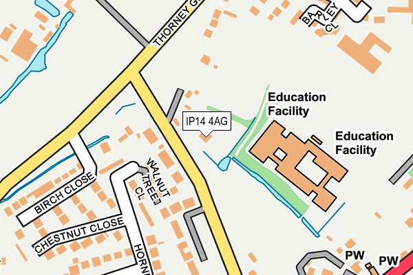
IP14 4AG lies on The Green in Stowupland, Stowmarket. IP14 4AG is located in the Haughley, Stowupland & Wetherden electoral ward, within the local authority district of Mid Suffolk and the English Parliamentary constituency of Bury St Edmunds. The Sub Integrated Care Board (ICB) Location is NHS Suffolk and North East Essex ICB - 06L and the police force is Suffolk. This postcode has been in use since January 1980.


GetTheData
Source: OS OpenMap – Local (Ordnance Survey)
Source: OS VectorMap District (Ordnance Survey)
Licence: Open Government Licence (requires attribution)
| Easting | 606600 |
| Northing | 259983 |
| Latitude | 52.199363 |
| Longitude | 1.021762 |
GetTheData
Source: Open Postcode Geo
Licence: Open Government Licence
| Street | The Green |
| Locality | Stowupland |
| Town/City | Stowmarket |
| Country | England |
| Postcode District | IP14 |
➜ See where IP14 is on a map ➜ Where is Stowupland? | |
GetTheData
Source: Land Registry Price Paid Data
Licence: Open Government Licence
Elevation or altitude of IP14 4AG as distance above sea level:
| Metres | Feet | |
|---|---|---|
| Elevation | 60m | 197ft |
Elevation is measured from the approximate centre of the postcode, to the nearest point on an OS contour line from OS Terrain 50, which has contour spacing of ten vertical metres.
➜ How high above sea level am I? Find the elevation of your current position using your device's GPS.
GetTheData
Source: Open Postcode Elevation
Licence: Open Government Licence
| Ward | Haughley, Stowupland & Wetherden |
| Constituency | Bury St Edmunds |
GetTheData
Source: ONS Postcode Database
Licence: Open Government Licence
THE RETREAT INN, THE GREEN, STOWUPLAND, STOWMARKET, IP14 4AG 2008 15 DEC £284,000 |
GetTheData
Source: HM Land Registry Price Paid Data
Licence: Contains HM Land Registry data © Crown copyright and database right 2024. This data is licensed under the Open Government Licence v3.0.
| The Retreat (The Green) | Stowupland | 54m |
| The Retreat (The Green) | Stowupland | 64m |
| Mill Cottages (Thorney Green) | Stowupland | 238m |
| Mill Cottages (Thorney Green) | Stowupland | 239m |
| High School (Stowupland High School) | Stowupland | 273m |
| Stowmarket Station | 1.8km |
GetTheData
Source: NaPTAN
Licence: Open Government Licence
GetTheData
Source: ONS Postcode Database
Licence: Open Government Licence


➜ Get more ratings from the Food Standards Agency
GetTheData
Source: Food Standards Agency
Licence: FSA terms & conditions
| Last Collection | |||
|---|---|---|---|
| Location | Mon-Fri | Sat | Distance |
| Post Office, Church Road | 17:15 | 10:15 | 556m |
| Royal Mail 62 Ipswich Street | 17:45 | 13:00 | 2,179m |
| Edgecomb Road | 17:00 | 11:00 | 3,247m |
GetTheData
Source: Dracos
Licence: Creative Commons Attribution-ShareAlike
The below table lists the International Territorial Level (ITL) codes (formerly Nomenclature of Territorial Units for Statistics (NUTS) codes) and Local Administrative Units (LAU) codes for IP14 4AG:
| ITL 1 Code | Name |
|---|---|
| TLH | East |
| ITL 2 Code | Name |
| TLH1 | East Anglia |
| ITL 3 Code | Name |
| TLH14 | Suffolk CC |
| LAU 1 Code | Name |
| E07000203 | Mid Suffolk |
GetTheData
Source: ONS Postcode Directory
Licence: Open Government Licence
The below table lists the Census Output Area (OA), Lower Layer Super Output Area (LSOA), and Middle Layer Super Output Area (MSOA) for IP14 4AG:
| Code | Name | |
|---|---|---|
| OA | E00153324 | |
| LSOA | E01030081 | Mid Suffolk 005D |
| MSOA | E02006265 | Mid Suffolk 005 |
GetTheData
Source: ONS Postcode Directory
Licence: Open Government Licence
| IP14 4AD | The Green | 66m |
| IP14 4AQ | The Green | 82m |
| IP14 4DZ | Walnut Tree Close | 107m |
| IP14 4DL | Hornbeam Road | 139m |
| IP14 4AE | The Green | 145m |
| IP14 4AH | The Green | 212m |
| IP14 4UP | Reeds Way | 247m |
| IP14 4DW | Birch Close | 248m |
| IP14 4DH | Maple Road | 251m |
| IP14 4DJ | Hornbeam Road | 255m |
GetTheData
Source: Open Postcode Geo; Land Registry Price Paid Data
Licence: Open Government Licence