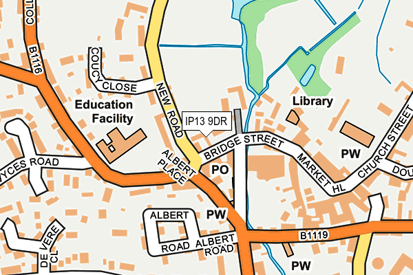
IP13 9DR is located in the Framlingham electoral ward, within the local authority district of East Suffolk and the English Parliamentary constituency of Central Suffolk and North Ipswich. The Sub Integrated Care Board (ICB) Location is NHS Suffolk and North East Essex ICB - 06L and the police force is Suffolk. This postcode has been in use since January 1980.


GetTheData
Source: OS OpenMap – Local (Ordnance Survey)
Source: OS VectorMap District (Ordnance Survey)
Licence: Open Government Licence (requires attribution)
| Easting | 628315 |
| Northing | 263506 |
| Latitude | 52.222409 |
| Longitude | 1.341300 |
GetTheData
Source: Open Postcode Geo
Licence: Open Government Licence
| Country | England |
| Postcode District | IP13 |
➜ See where IP13 is on a map ➜ Where is Framlingham? | |
GetTheData
Source: Land Registry Price Paid Data
Licence: Open Government Licence
Elevation or altitude of IP13 9DR as distance above sea level:
| Metres | Feet | |
|---|---|---|
| Elevation | 30m | 98ft |
Elevation is measured from the approximate centre of the postcode, to the nearest point on an OS contour line from OS Terrain 50, which has contour spacing of ten vertical metres.
➜ How high above sea level am I? Find the elevation of your current position using your device's GPS.
GetTheData
Source: Open Postcode Elevation
Licence: Open Government Licence
| Ward | Framlingham |
| Constituency | Central Suffolk And North Ipswich |
GetTheData
Source: ONS Postcode Database
Licence: Open Government Licence
| Shelter (Bridge Street) | Framlingham | 28m |
| White Horse (College Road) | Framlingham | 85m |
| School Entrance (New Road) | Framlingham | 88m |
| Pembroke Road (College Road) | Framlingham | 399m |
| Victoria Mill Road (Station Road) | Framlingham | 410m |
GetTheData
Source: NaPTAN
Licence: Open Government Licence
GetTheData
Source: ONS Postcode Database
Licence: Open Government Licence


➜ Get more ratings from the Food Standards Agency
GetTheData
Source: Food Standards Agency
Licence: FSA terms & conditions
| Last Collection | |||
|---|---|---|---|
| Location | Mon-Fri | Sat | Distance |
| Riverside Post Office | 17:00 | 10:15 | 81m |
| Market Hill | 14:30 | 07:15 | 155m |
| College Road | 16:30 | 09:00 | 266m |
GetTheData
Source: Dracos
Licence: Creative Commons Attribution-ShareAlike
| Risk of IP13 9DR flooding from rivers and sea | Low |
| ➜ IP13 9DR flood map | |
GetTheData
Source: Open Flood Risk by Postcode
Licence: Open Government Licence
The below table lists the International Territorial Level (ITL) codes (formerly Nomenclature of Territorial Units for Statistics (NUTS) codes) and Local Administrative Units (LAU) codes for IP13 9DR:
| ITL 1 Code | Name |
|---|---|
| TLH | East |
| ITL 2 Code | Name |
| TLH1 | East Anglia |
| ITL 3 Code | Name |
| TLH14 | Suffolk CC |
| LAU 1 Code | Name |
| E07000244 | East Suffolk |
GetTheData
Source: ONS Postcode Directory
Licence: Open Government Licence
The below table lists the Census Output Area (OA), Lower Layer Super Output Area (LSOA), and Middle Layer Super Output Area (MSOA) for IP13 9DR:
| Code | Name | |
|---|---|---|
| OA | E00153844 | |
| LSOA | E01030173 | Suffolk Coastal 002C |
| MSOA | E02006288 | Suffolk Coastal 002 |
GetTheData
Source: ONS Postcode Directory
Licence: Open Government Licence
| IP13 9DP | Bridge Street | 32m |
| IP13 9GA | Tanyard Court | 52m |
| IP13 9DU | Well Close Square | 61m |
| IP13 9DS | Well Close Square | 73m |
| IP13 9DT | Well Close Square | 83m |
| IP13 9EH | New Road | 98m |
| IP13 9AH | Bridge Street | 105m |
| IP13 9AJ | Bridge Street | 105m |
| IP13 9GB | Bridge Street | 108m |
| IP13 9DX | Albert Place | 139m |
GetTheData
Source: Open Postcode Geo; Land Registry Price Paid Data
Licence: Open Government Licence