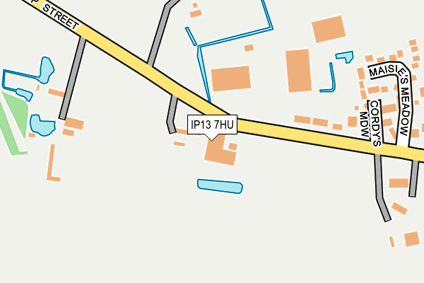
IP13 7HU is located in the Hoxne & Worlingworth electoral ward, within the local authority district of Mid Suffolk and the English Parliamentary constituency of Central Suffolk and North Ipswich. The Sub Integrated Care Board (ICB) Location is NHS Suffolk and North East Essex ICB - 06L and the police force is Suffolk. This postcode has been in use since January 1980.


GetTheData
Source: OS OpenMap – Local (Ordnance Survey)
Source: OS VectorMap District (Ordnance Survey)
Licence: Open Government Licence (requires attribution)
| Easting | 621705 |
| Northing | 268523 |
| Latitude | 52.270157 |
| Longitude | 1.248015 |
GetTheData
Source: Open Postcode Geo
Licence: Open Government Licence
| Country | England |
| Postcode District | IP13 |
➜ See where IP13 is on a map ➜ Where is Worlingworth? | |
GetTheData
Source: Land Registry Price Paid Data
Licence: Open Government Licence
Elevation or altitude of IP13 7HU as distance above sea level:
| Metres | Feet | |
|---|---|---|
| Elevation | 60m | 197ft |
Elevation is measured from the approximate centre of the postcode, to the nearest point on an OS contour line from OS Terrain 50, which has contour spacing of ten vertical metres.
➜ How high above sea level am I? Find the elevation of your current position using your device's GPS.
GetTheData
Source: Open Postcode Elevation
Licence: Open Government Licence
| Ward | Hoxne & Worlingworth |
| Constituency | Central Suffolk And North Ipswich |
GetTheData
Source: ONS Postcode Database
Licence: Open Government Licence
| Maisies Meadow (Shop Street) | Worlingworth | 241m |
| Maisies Meadow (Shop Street) | Worlingworth | 246m |
| Letter Box (Mill Road) | Worlingworth | 628m |
| Letter Box (Mill Road) | Worlingworth | 644m |
| The Cross (Church Road) | Worlingworth | 815m |
GetTheData
Source: NaPTAN
Licence: Open Government Licence
GetTheData
Source: ONS Postcode Database
Licence: Open Government Licence


➜ Get more ratings from the Food Standards Agency
GetTheData
Source: Food Standards Agency
Licence: FSA terms & conditions
| Last Collection | |||
|---|---|---|---|
| Location | Mon-Fri | Sat | Distance |
| Little Green | 15:45 | 11:15 | 2,235m |
| The Street | 11:15 | 11:15 | 3,583m |
| Post Office, The Street | 16:00 | 10:45 | 4,134m |
GetTheData
Source: Dracos
Licence: Creative Commons Attribution-ShareAlike
The below table lists the International Territorial Level (ITL) codes (formerly Nomenclature of Territorial Units for Statistics (NUTS) codes) and Local Administrative Units (LAU) codes for IP13 7HU:
| ITL 1 Code | Name |
|---|---|
| TLH | East |
| ITL 2 Code | Name |
| TLH1 | East Anglia |
| ITL 3 Code | Name |
| TLH14 | Suffolk CC |
| LAU 1 Code | Name |
| E07000203 | Mid Suffolk |
GetTheData
Source: ONS Postcode Directory
Licence: Open Government Licence
The below table lists the Census Output Area (OA), Lower Layer Super Output Area (LSOA), and Middle Layer Super Output Area (MSOA) for IP13 7HU:
| Code | Name | |
|---|---|---|
| OA | E00153379 | |
| LSOA | E01030090 | Mid Suffolk 003C |
| MSOA | E02006263 | Mid Suffolk 003 |
GetTheData
Source: ONS Postcode Directory
Licence: Open Government Licence
| IP13 7HT | Shop Street | 237m |
| IP13 7JN | Shop Street | 241m |
| IP13 7JL | Maisies Meadow | 284m |
| IP13 7HX | Shop Street | 371m |
| IP13 7GX | Jessop Close | 384m |
| IP13 7HR | New Town | 448m |
| IP13 7PG | Pipers Meadow | 475m |
| IP13 7JW | Old Stores Close | 545m |
| IP13 7HP | Mill Road | 562m |
| IP13 7RQ | Willow Farm Meadow | 588m |
GetTheData
Source: Open Postcode Geo; Land Registry Price Paid Data
Licence: Open Government Licence