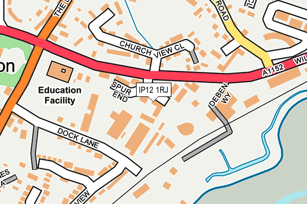
IP12 1RJ lies on Wilford Bridge Spur in Melton, Woodbridge. IP12 1RJ is located in the Melton electoral ward, within the local authority district of East Suffolk and the English Parliamentary constituency of Suffolk Coastal. The Sub Integrated Care Board (ICB) Location is NHS Suffolk and North East Essex ICB - 06L and the police force is Suffolk. This postcode has been in use since April 1986.


GetTheData
Source: OS OpenMap – Local (Ordnance Survey)
Source: OS VectorMap District (Ordnance Survey)
Licence: Open Government Licence (requires attribution)
| Easting | 628353 |
| Northing | 250293 |
| Latitude | 52.103804 |
| Longitude | 1.332975 |
GetTheData
Source: Open Postcode Geo
Licence: Open Government Licence
| Street | Wilford Bridge Spur |
| Locality | Melton |
| Town/City | Woodbridge |
| Country | England |
| Postcode District | IP12 |
➜ See where IP12 is on a map ➜ Where is Melton? | |
GetTheData
Source: Land Registry Price Paid Data
Licence: Open Government Licence
Elevation or altitude of IP12 1RJ as distance above sea level:
| Metres | Feet | |
|---|---|---|
| Elevation | 0m | 0ft |
Elevation is measured from the approximate centre of the postcode, to the nearest point on an OS contour line from OS Terrain 50, which has contour spacing of ten vertical metres.
➜ How high above sea level am I? Find the elevation of your current position using your device's GPS.
GetTheData
Source: Open Postcode Elevation
Licence: Open Government Licence
| Ward | Melton |
| Constituency | Suffolk Coastal |
GetTheData
Source: ONS Postcode Database
Licence: Open Government Licence
| St Andrews Place (Station Road) | Melton | 271m |
| St Andrews Place (Station Road) | Melton | 281m |
| Chapel (The Street) | Melton | 287m |
| Chapel (The Street) | Melton | 304m |
| Coach And Horses (Melton Road) | Melton | 304m |
| Melton (Suffolk) Station | 0.4km |
| Woodbridge Station | 1.8km |
GetTheData
Source: NaPTAN
Licence: Open Government Licence
GetTheData
Source: ONS Postcode Database
Licence: Open Government Licence


➜ Get more ratings from the Food Standards Agency
GetTheData
Source: Food Standards Agency
Licence: FSA terms & conditions
| Last Collection | |||
|---|---|---|---|
| Location | Mon-Fri | Sat | Distance |
| St. Andrews Place | 16:45 | 09:00 | 279m |
| The Street | 17:30 | 09:00 | 301m |
| Railway Station | 17:00 | 10:00 | 369m |
GetTheData
Source: Dracos
Licence: Creative Commons Attribution-ShareAlike
| Risk of IP12 1RJ flooding from rivers and sea | Low |
| ➜ IP12 1RJ flood map | |
GetTheData
Source: Open Flood Risk by Postcode
Licence: Open Government Licence
The below table lists the International Territorial Level (ITL) codes (formerly Nomenclature of Territorial Units for Statistics (NUTS) codes) and Local Administrative Units (LAU) codes for IP12 1RJ:
| ITL 1 Code | Name |
|---|---|
| TLH | East |
| ITL 2 Code | Name |
| TLH1 | East Anglia |
| ITL 3 Code | Name |
| TLH14 | Suffolk CC |
| LAU 1 Code | Name |
| E07000244 | East Suffolk |
GetTheData
Source: ONS Postcode Directory
Licence: Open Government Licence
The below table lists the Census Output Area (OA), Lower Layer Super Output Area (LSOA), and Middle Layer Super Output Area (MSOA) for IP12 1RJ:
| Code | Name | |
|---|---|---|
| OA | E00153956 | |
| LSOA | E01030194 | Suffolk Coastal 005B |
| MSOA | E02006291 | Suffolk Coastal 005 |
GetTheData
Source: ONS Postcode Directory
Licence: Open Government Licence
| IP12 1RD | Church View Close | 110m |
| IP12 1PE | Dock Lane | 157m |
| IP12 1SR | The Debenside | 175m |
| IP12 1RG | Friars Court | 178m |
| IP12 1RQ | Blakes Close | 197m |
| IP12 1RF | Church View Close | 205m |
| IP12 1PY | Station Road | 223m |
| IP12 1PX | Station Road | 239m |
| IP12 1QU | Riverview | 244m |
| IP12 1PW | The Street | 251m |
GetTheData
Source: Open Postcode Geo; Land Registry Price Paid Data
Licence: Open Government Licence