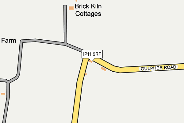
IP11 9RF lies on Gulpher Road in Felixstowe. IP11 9RF is located in the Eastern Felixstowe electoral ward, within the local authority district of East Suffolk and the English Parliamentary constituency of Suffolk Coastal. The Sub Integrated Care Board (ICB) Location is NHS Suffolk and North East Essex ICB - 06L and the police force is Suffolk. This postcode has been in use since January 1980.


GetTheData
Source: OS OpenMap – Local (Ordnance Survey)
Source: OS VectorMap District (Ordnance Survey)
Licence: Open Government Licence (requires attribution)
| Easting | 630125 |
| Northing | 236784 |
| Latitude | 51.981838 |
| Longitude | 1.349746 |
GetTheData
Source: Open Postcode Geo
Licence: Open Government Licence
| Street | Gulpher Road |
| Town/City | Felixstowe |
| Country | England |
| Postcode District | IP11 |
➜ See where IP11 is on a map | |
GetTheData
Source: Land Registry Price Paid Data
Licence: Open Government Licence
Elevation or altitude of IP11 9RF as distance above sea level:
| Metres | Feet | |
|---|---|---|
| Elevation | 10m | 33ft |
Elevation is measured from the approximate centre of the postcode, to the nearest point on an OS contour line from OS Terrain 50, which has contour spacing of ten vertical metres.
➜ How high above sea level am I? Find the elevation of your current position using your device's GPS.
GetTheData
Source: Open Postcode Elevation
Licence: Open Government Licence
| Ward | Eastern Felixstowe |
| Constituency | Suffolk Coastal |
GetTheData
Source: ONS Postcode Database
Licence: Open Government Licence
| Beatrice Avenue | Old Felixstowe | 1,162m |
| Beatrice Avenue | Old Felixstowe | 1,182m |
| Sunningdale Drive (Colneis Road) | Old Felixstowe | 1,277m |
| Rosemary Avenue | Old Felixstowe | 1,289m |
| St Marys Church (High Street) | Walton | 1,300m |
| Felixstowe Station | 1.6km |
| Trimley Station | 2.2km |
| Harwich Town Station | 6km |
GetTheData
Source: NaPTAN
Licence: Open Government Licence
| Percentage of properties with Next Generation Access | 100.0% |
| Percentage of properties with Superfast Broadband | 100.0% |
| Percentage of properties with Ultrafast Broadband | 0.0% |
| Percentage of properties with Full Fibre Broadband | 0.0% |
Superfast Broadband is between 30Mbps and 300Mbps
Ultrafast Broadband is > 300Mbps
| Percentage of properties unable to receive 2Mbps | 0.0% |
| Percentage of properties unable to receive 5Mbps | 0.0% |
| Percentage of properties unable to receive 10Mbps | 0.0% |
| Percentage of properties unable to receive 30Mbps | 0.0% |
GetTheData
Source: Ofcom
Licence: Ofcom Terms of Use (requires attribution)
GetTheData
Source: ONS Postcode Database
Licence: Open Government Licence


➜ Get more ratings from the Food Standards Agency
GetTheData
Source: Food Standards Agency
Licence: FSA terms & conditions
| Last Collection | |||
|---|---|---|---|
| Location | Mon-Fri | Sat | Distance |
| Marsh Lane | 16:30 | 11:45 | 1,458m |
| Langstons, Faulkeners Way | 17:00 | 07:00 | 1,604m |
| 29 Foxgrove Ln | 17:15 | 12:00 | 1,803m |
GetTheData
Source: Dracos
Licence: Creative Commons Attribution-ShareAlike
The below table lists the International Territorial Level (ITL) codes (formerly Nomenclature of Territorial Units for Statistics (NUTS) codes) and Local Administrative Units (LAU) codes for IP11 9RF:
| ITL 1 Code | Name |
|---|---|
| TLH | East |
| ITL 2 Code | Name |
| TLH1 | East Anglia |
| ITL 3 Code | Name |
| TLH14 | Suffolk CC |
| LAU 1 Code | Name |
| E07000244 | East Suffolk |
GetTheData
Source: ONS Postcode Directory
Licence: Open Government Licence
The below table lists the Census Output Area (OA), Lower Layer Super Output Area (LSOA), and Middle Layer Super Output Area (MSOA) for IP11 9RF:
| Code | Name | |
|---|---|---|
| OA | E00153783 | |
| LSOA | E01030160 | Suffolk Coastal 014A |
| MSOA | E02006300 | Suffolk Coastal 014 |
GetTheData
Source: ONS Postcode Directory
Licence: Open Government Licence
| IP11 9RE | Brick Kiln Cottages | 185m |
| IP11 9RB | Gulpher Road | 318m |
| IP11 9RG | Gulpher Road | 391m |
| IP11 9RA | Gulpher Road | 433m |
| IP11 9RQ | Gulpher Road | 574m |
| IP11 9RD | Gulpher Road | 953m |
| IP11 9ER | Tree Tops | 1100m |
| IP11 9DH | Ataka Road | 1103m |
| IP11 9DN | Gulpher Road | 1114m |
| IP11 9HD | Links Avenue | 1120m |
GetTheData
Source: Open Postcode Geo; Land Registry Price Paid Data
Licence: Open Government Licence