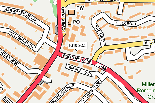
IG10 2QZ is located in the Loughton St John's electoral ward, within the local authority district of Epping Forest and the English Parliamentary constituency of Epping Forest. The Sub Integrated Care Board (ICB) Location is NHS Hertfordshire and West Essex ICB - 07H and the police force is Essex. This postcode has been in use since June 2000.


GetTheData
Source: OS OpenMap – Local (Ordnance Survey)
Source: OS VectorMap District (Ordnance Survey)
Licence: Open Government Licence (requires attribution)
| Easting | 543152 |
| Northing | 197279 |
| Latitude | 51.656076 |
| Longitude | 0.068051 |
GetTheData
Source: Open Postcode Geo
Licence: Open Government Licence
| Country | England |
| Postcode District | IG10 |
➜ See where IG10 is on a map ➜ Where is Loughton? | |
GetTheData
Source: Land Registry Price Paid Data
Licence: Open Government Licence
Elevation or altitude of IG10 2QZ as distance above sea level:
| Metres | Feet | |
|---|---|---|
| Elevation | 50m | 164ft |
Elevation is measured from the approximate centre of the postcode, to the nearest point on an OS contour line from OS Terrain 50, which has contour spacing of ten vertical metres.
➜ How high above sea level am I? Find the elevation of your current position using your device's GPS.
GetTheData
Source: Open Postcode Elevation
Licence: Open Government Licence
| Ward | Loughton St John's |
| Constituency | Epping Forest |
GetTheData
Source: ONS Postcode Database
Licence: Open Government Licence
| Hillyfields (Rectory Lane) | Debden | 21m |
| Hillyfields (Rectory Lane) | Debden | 28m |
| Homebase (Church Hill) | Loughton | 107m |
| Homebase (Church Hill) | Loughton | 107m |
| The Croft (Hillyfield) | Debden | 114m |
| Debden Underground Station | Debden | 1,612m |
| Chingford Station | 4.8km |
GetTheData
Source: NaPTAN
Licence: Open Government Licence
GetTheData
Source: ONS Postcode Database
Licence: Open Government Licence


➜ Get more ratings from the Food Standards Agency
GetTheData
Source: Food Standards Agency
Licence: FSA terms & conditions
| Last Collection | |||
|---|---|---|---|
| Location | Mon-Fri | Sat | Distance |
| Burney Drive | 17:15 | 12:00 | 737m |
| Newmans Lane | 17:30 | 12:00 | 760m |
| Alderton Hill | 17:15 | 12:00 | 1,170m |
GetTheData
Source: Dracos
Licence: Creative Commons Attribution-ShareAlike
The below table lists the International Territorial Level (ITL) codes (formerly Nomenclature of Territorial Units for Statistics (NUTS) codes) and Local Administrative Units (LAU) codes for IG10 2QZ:
| ITL 1 Code | Name |
|---|---|
| TLH | East |
| ITL 2 Code | Name |
| TLH3 | Essex |
| ITL 3 Code | Name |
| TLH35 | West Essex |
| LAU 1 Code | Name |
| E07000072 | Epping Forest |
GetTheData
Source: ONS Postcode Directory
Licence: Open Government Licence
The below table lists the Census Output Area (OA), Lower Layer Super Output Area (LSOA), and Middle Layer Super Output Area (MSOA) for IG10 2QZ:
| Code | Name | |
|---|---|---|
| OA | E00110671 | |
| LSOA | E01021786 | Epping Forest 012A |
| MSOA | E02004538 | Epping Forest 012 |
GetTheData
Source: ONS Postcode Directory
Licence: Open Government Licence
| IG10 2PW | Hillyfields | 56m |
| IG10 2RW | Goldings Hill | 64m |
| IG10 1PR | Maple Gate | 70m |
| IG10 1PS | Maple Gate | 100m |
| IG10 1LL | Goldings Hill | 102m |
| IG10 1LJ | Church Hill | 107m |
| IG10 2RS | Lower Road | 113m |
| IG10 1LX | Harwater Drive | 123m |
| IG10 2PP | The Croft | 132m |
| IG10 1LN | Goldings Hill | 133m |
GetTheData
Source: Open Postcode Geo; Land Registry Price Paid Data
Licence: Open Government Licence