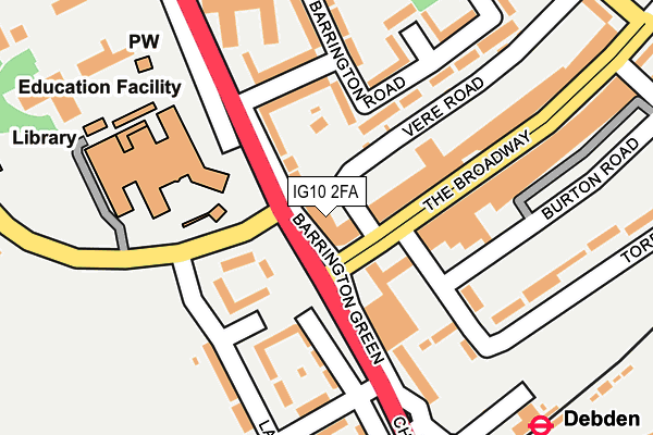
IG10 2FA is located in the Loughton Broadway electoral ward, within the local authority district of Epping Forest and the English Parliamentary constituency of Epping Forest. The Sub Integrated Care Board (ICB) Location is NHS Hertfordshire and West Essex ICB - 07H and the police force is Essex. This postcode has been in use since July 2017.


GetTheData
Source: OS OpenMap – Local (Ordnance Survey)
Source: OS VectorMap District (Ordnance Survey)
Licence: Open Government Licence (requires attribution)
| Easting | 544086 |
| Northing | 196315 |
| Latitude | 51.647178 |
| Longitude | 0.081173 |
GetTheData
Source: Open Postcode Geo
Licence: Open Government Licence
| Country | England |
| Postcode District | IG10 |
➜ See where IG10 is on a map ➜ Where is Loughton? | |
GetTheData
Source: Land Registry Price Paid Data
Licence: Open Government Licence
| Ward | Loughton Broadway |
| Constituency | Epping Forest |
GetTheData
Source: ONS Postcode Database
Licence: Open Government Licence
| Police Station (Vere Road) | Debden | 24m |
| Rectory Lane (The Broadway) | Debden | 52m |
| The Broadway (Torrington Drive) | Debden | 78m |
| Torrington Drive (Broadway The) | Debden | 85m |
| Borders Lane (Rectory Lane) | Debden | 85m |
| Debden Underground Station | Debden | 270m |
| Chingford Station | 5.2km |
GetTheData
Source: NaPTAN
Licence: Open Government Licence
| Percentage of properties with Next Generation Access | 100.0% |
| Percentage of properties with Superfast Broadband | 100.0% |
| Percentage of properties with Ultrafast Broadband | 100.0% |
| Percentage of properties with Full Fibre Broadband | 100.0% |
Superfast Broadband is between 30Mbps and 300Mbps
Ultrafast Broadband is > 300Mbps
| Median download speed | 100.0Mbps |
| Average download speed | 135.3Mbps |
| Maximum download speed | 350.00Mbps |
Ofcom does not currently provide upload speed data for IG10 2FA. This is because there are less than four broadband connections in this postcode.
| Percentage of properties unable to receive 2Mbps | 0.0% |
| Percentage of properties unable to receive 5Mbps | 0.0% |
| Percentage of properties unable to receive 10Mbps | 0.0% |
| Percentage of properties unable to receive 30Mbps | 0.0% |
GetTheData
Source: Ofcom
Licence: Ofcom Terms of Use (requires attribution)
GetTheData
Source: ONS Postcode Database
Licence: Open Government Licence


➜ Get more ratings from the Food Standards Agency
GetTheData
Source: Food Standards Agency
Licence: FSA terms & conditions
| Last Collection | |||
|---|---|---|---|
| Location | Mon-Fri | Sat | Distance |
| Debden Broadway Post Office | 18:30 | 12:00 | 108m |
| Newmans Lane | 17:30 | 12:00 | 594m |
| Deepdene Road | 17:00 | 12:00 | 713m |
GetTheData
Source: Dracos
Licence: Creative Commons Attribution-ShareAlike
The below table lists the International Territorial Level (ITL) codes (formerly Nomenclature of Territorial Units for Statistics (NUTS) codes) and Local Administrative Units (LAU) codes for IG10 2FA:
| ITL 1 Code | Name |
|---|---|
| TLH | East |
| ITL 2 Code | Name |
| TLH3 | Essex |
| ITL 3 Code | Name |
| TLH35 | West Essex |
| LAU 1 Code | Name |
| E07000072 | Epping Forest |
GetTheData
Source: ONS Postcode Directory
Licence: Open Government Licence
The below table lists the Census Output Area (OA), Lower Layer Super Output Area (LSOA), and Middle Layer Super Output Area (MSOA) for IG10 2FA:
| Code | Name | |
|---|---|---|
| OA | E00110612 | |
| LSOA | E01021776 | Epping Forest 011C |
| MSOA | E02004537 | Epping Forest 011 |
GetTheData
Source: ONS Postcode Directory
Licence: Open Government Licence
| IG10 3RZ | Borders Lane | 91m |
| IG10 3RS | Ladyfields Close | 104m |
| IG10 2BA | Barrington Green | 113m |
| IG10 3RT | Ladyfields | 118m |
| IG10 3RW | Chigwell Lane | 143m |
| IG10 3SX | The Broadway | 153m |
| IG10 3UA | Chigwell Lane | 160m |
| IG10 3RN | Colson Road | 167m |
| IG10 2AY | Barrington Road | 175m |
| IG10 3RR | Ladyfields | 185m |
GetTheData
Source: Open Postcode Geo; Land Registry Price Paid Data
Licence: Open Government Licence