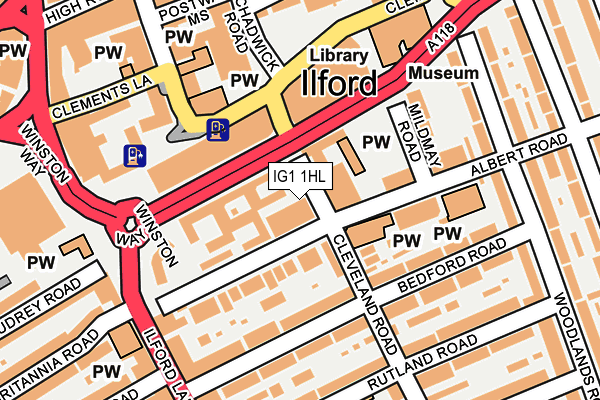
IG1 1HL is located in the Clementswood electoral ward, within the London borough of Redbridge and the English Parliamentary constituency of Ilford South. The Sub Integrated Care Board (ICB) Location is NHS North East London ICB - A3A8R and the police force is Metropolitan Police. This postcode has been in use since January 1980.


GetTheData
Source: OS OpenMap – Local (Ordnance Survey)
Source: OS VectorMap District (Ordnance Survey)
Licence: Open Government Licence (requires attribution)
| Easting | 543868 |
| Northing | 186231 |
| Latitude | 51.556623 |
| Longitude | 0.073865 |
GetTheData
Source: Open Postcode Geo
Licence: Open Government Licence
| Country | England |
| Postcode District | IG1 |
➜ See where IG1 is on a map ➜ Where is Ilford? | |
GetTheData
Source: Land Registry Price Paid Data
Licence: Open Government Licence
Elevation or altitude of IG1 1HL as distance above sea level:
| Metres | Feet | |
|---|---|---|
| Elevation | 10m | 33ft |
Elevation is measured from the approximate centre of the postcode, to the nearest point on an OS contour line from OS Terrain 50, which has contour spacing of ten vertical metres.
➜ How high above sea level am I? Find the elevation of your current position using your device's GPS.
GetTheData
Source: Open Postcode Elevation
Licence: Open Government Licence
| Ward | Clementswood |
| Constituency | Ilford South |
GetTheData
Source: ONS Postcode Database
Licence: Open Government Licence
| Redbridge Central Library (Clements Road) | Ilford | 142m |
| Redbridge Central Library | Ilford | 173m |
| Bengal Road | Ilford | 209m |
| High Road Ilford (Clements Road) | Ilford | 223m |
| Pioneer Point | Ilford | 231m |
| Ilford Station | 0.4km |
| Seven Kings Station | 1.8km |
| Manor Park Station | 2km |
GetTheData
Source: NaPTAN
Licence: Open Government Licence
GetTheData
Source: ONS Postcode Database
Licence: Open Government Licence


➜ Get more ratings from the Food Standards Agency
GetTheData
Source: Food Standards Agency
Licence: FSA terms & conditions
| Last Collection | |||
|---|---|---|---|
| Location | Mon-Fri | Sat | Distance |
| High Road | 18:30 | 12:00 | 47m |
| Ilford Delivery Office | 206m | ||
| Ilford Delivery Office | 18:30 | 12:00 | 222m |
GetTheData
Source: Dracos
Licence: Creative Commons Attribution-ShareAlike
The below table lists the International Territorial Level (ITL) codes (formerly Nomenclature of Territorial Units for Statistics (NUTS) codes) and Local Administrative Units (LAU) codes for IG1 1HL:
| ITL 1 Code | Name |
|---|---|
| TLI | London |
| ITL 2 Code | Name |
| TLI5 | Outer London - East and North East |
| ITL 3 Code | Name |
| TLI53 | Redbridge and Waltham Forest |
| LAU 1 Code | Name |
| E09000026 | Redbridge |
GetTheData
Source: ONS Postcode Directory
Licence: Open Government Licence
The below table lists the Census Output Area (OA), Lower Layer Super Output Area (LSOA), and Middle Layer Super Output Area (MSOA) for IG1 1HL:
| Code | Name | |
|---|---|---|
| OA | E00018544 | |
| LSOA | E01003689 | Redbridge 030G |
| MSOA | E02000780 | Redbridge 030 |
GetTheData
Source: ONS Postcode Directory
Licence: Open Government Licence
| IG1 1HN | Albert Road | 94m |
| IG1 1DU | Albert Road | 101m |
| IG1 1GH | Albert Road | 105m |
| IG1 1EJ | Bedford Road | 125m |
| IG1 1DT | Mildmay Road | 144m |
| IG1 1NG | Albert Road | 158m |
| IG1 1EL | Bedford Road | 168m |
| IG1 1BH | Clements Road | 175m |
| IG1 1JJ | Woodlands Road | 193m |
| IG1 2RJ | Ilford Lane | 194m |
GetTheData
Source: Open Postcode Geo; Land Registry Price Paid Data
Licence: Open Government Licence