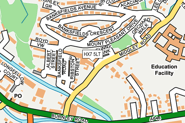
HX7 5LT is located in the Luddendenfoot electoral ward, within the metropolitan district of Calderdale and the English Parliamentary constituency of Calder Valley. The Sub Integrated Care Board (ICB) Location is NHS West Yorkshire ICB - 02T and the police force is West Yorkshire. This postcode has been in use since January 1980.


GetTheData
Source: OS OpenMap – Local (Ordnance Survey)
Source: OS VectorMap District (Ordnance Survey)
Licence: Open Government Licence (requires attribution)
| Easting | 401458 |
| Northing | 426192 |
| Latitude | 53.732120 |
| Longitude | -1.979378 |
GetTheData
Source: Open Postcode Geo
Licence: Open Government Licence
| Country | England |
| Postcode District | HX7 |
➜ See where HX7 is on a map ➜ Where is Mytholmroyd? | |
GetTheData
Source: Land Registry Price Paid Data
Licence: Open Government Licence
Elevation or altitude of HX7 5LT as distance above sea level:
| Metres | Feet | |
|---|---|---|
| Elevation | 100m | 328ft |
Elevation is measured from the approximate centre of the postcode, to the nearest point on an OS contour line from OS Terrain 50, which has contour spacing of ten vertical metres.
➜ How high above sea level am I? Find the elevation of your current position using your device's GPS.
GetTheData
Source: Open Postcode Elevation
Licence: Open Government Licence
| Ward | Luddendenfoot |
| Constituency | Calder Valley |
GetTheData
Source: ONS Postcode Database
Licence: Open Government Licence
| Mount Pleasant Dr Banksfield Ave (Mount Pleasant Drive) | Mytholmroyd | 53m |
| Midgley Road Sunny Bank (Midgley Road) | Mytholmroyd | 80m |
| Midgley Rd Mabel Street (Midgley Road) | Mytholmroyd | 93m |
| Mount Pleasant Drive Banksfield Ave (Mount Pleasant Drive) | Mytholmroyd | 144m |
| Banksfields Ave Banksfield Cresc (Banksfield Avenue) | Mytholmroyd | 168m |
| Mytholmroyd Station | 0.4km |
| Hebden Bridge Station | 2.1km |
| Sowerby Bridge Station | 5.5km |
GetTheData
Source: NaPTAN
Licence: Open Government Licence
GetTheData
Source: ONS Postcode Database
Licence: Open Government Licence


➜ Get more ratings from the Food Standards Agency
GetTheData
Source: Food Standards Agency
Licence: FSA terms & conditions
| Last Collection | |||
|---|---|---|---|
| Location | Mon-Fri | Sat | Distance |
| Mytholmroyd P.o. Box | 17:15 | 12:00 | 305m |
| Railway Station Mytholmroyd | 16:15 | 10:30 | 368m |
| 2 Cragg Road | 16:45 | 10:30 | 685m |
GetTheData
Source: Dracos
Licence: Creative Commons Attribution-ShareAlike
| Risk of HX7 5LT flooding from rivers and sea | Low |
| ➜ HX7 5LT flood map | |
GetTheData
Source: Open Flood Risk by Postcode
Licence: Open Government Licence
The below table lists the International Territorial Level (ITL) codes (formerly Nomenclature of Territorial Units for Statistics (NUTS) codes) and Local Administrative Units (LAU) codes for HX7 5LT:
| ITL 1 Code | Name |
|---|---|
| TLE | Yorkshire and The Humber |
| ITL 2 Code | Name |
| TLE4 | West Yorkshire |
| ITL 3 Code | Name |
| TLE44 | Calderdale and Kirklees |
| LAU 1 Code | Name |
| E08000033 | Calderdale |
GetTheData
Source: ONS Postcode Directory
Licence: Open Government Licence
The below table lists the Census Output Area (OA), Lower Layer Super Output Area (LSOA), and Middle Layer Super Output Area (MSOA) for HX7 5LT:
| Code | Name | |
|---|---|---|
| OA | E00055057 | |
| LSOA | E01010919 | Calderdale 007C |
| MSOA | E02002250 | Calderdale 007 |
GetTheData
Source: ONS Postcode Directory
Licence: Open Government Licence
| HX7 5LR | Midgley Road | 33m |
| HX7 5LS | Sunny Bank | 40m |
| HX7 5NR | Ribstone Street | 74m |
| HX7 5LX | Lower White Lee | 77m |
| HX7 5NP | Jubilee Street | 78m |
| HX7 5LP | Mabel Street | 112m |
| HX7 5NW | Banksfield Road | 115m |
| HX7 5NQ | Mount Pleasant Drive | 117m |
| HX7 5NU | Zion Terrace | 121m |
| HX7 5NG | Banksfield Crescent | 121m |
GetTheData
Source: Open Postcode Geo; Land Registry Price Paid Data
Licence: Open Government Licence