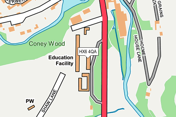
HX6 4QA is located in the Ryburn electoral ward, within the metropolitan district of Calderdale and the English Parliamentary constituency of Calder Valley. The Sub Integrated Care Board (ICB) Location is NHS West Yorkshire ICB - 02T and the police force is West Yorkshire. This postcode has been in use since January 1980.


GetTheData
Source: OS OpenMap – Local (Ordnance Survey)
Source: OS VectorMap District (Ordnance Survey)
Licence: Open Government Licence (requires attribution)
| Easting | 403398 |
| Northing | 418549 |
| Latitude | 53.663415 |
| Longitude | -1.950052 |
GetTheData
Source: Open Postcode Geo
Licence: Open Government Licence
| Country | England |
| Postcode District | HX6 |
➜ See where HX6 is on a map ➜ Where is Ripponden? | |
GetTheData
Source: Land Registry Price Paid Data
Licence: Open Government Licence
Elevation or altitude of HX6 4QA as distance above sea level:
| Metres | Feet | |
|---|---|---|
| Elevation | 160m | 525ft |
Elevation is measured from the approximate centre of the postcode, to the nearest point on an OS contour line from OS Terrain 50, which has contour spacing of ten vertical metres.
➜ How high above sea level am I? Find the elevation of your current position using your device's GPS.
GetTheData
Source: Open Postcode Elevation
Licence: Open Government Licence
| Ward | Ryburn |
| Constituency | Calder Valley |
GetTheData
Source: ONS Postcode Database
Licence: Open Government Licence
| Rishworth School (Oldham Road) | Rishworth | 250m |
| Rishworth School (Somerset Road) | Rishworth | 252m |
| Oldham Road School (Oldham Road) | Rishworth | 268m |
| Oldham Road School (Oldham Road) | Rishworth | 294m |
| Godley Lane (Rishworth New Road) | Rishworth | 322m |
| Sowerby Bridge Station | 5.7km |
| Slaithwaite Station | 6.3km |
GetTheData
Source: NaPTAN
Licence: Open Government Licence
GetTheData
Source: ONS Postcode Database
Licence: Open Government Licence


➜ Get more ratings from the Food Standards Agency
GetTheData
Source: Food Standards Agency
Licence: FSA terms & conditions
| Last Collection | |||
|---|---|---|---|
| Location | Mon-Fri | Sat | Distance |
| Commons | 16:45 | 10:00 | 326m |
| Oldham Road Ripponden | 17:15 | 11:00 | 506m |
| Dyson Lane Ripponden | 17:00 | 08:30 | 573m |
GetTheData
Source: Dracos
Licence: Creative Commons Attribution-ShareAlike
The below table lists the International Territorial Level (ITL) codes (formerly Nomenclature of Territorial Units for Statistics (NUTS) codes) and Local Administrative Units (LAU) codes for HX6 4QA:
| ITL 1 Code | Name |
|---|---|
| TLE | Yorkshire and The Humber |
| ITL 2 Code | Name |
| TLE4 | West Yorkshire |
| ITL 3 Code | Name |
| TLE44 | Calderdale and Kirklees |
| LAU 1 Code | Name |
| E08000033 | Calderdale |
GetTheData
Source: ONS Postcode Directory
Licence: Open Government Licence
The below table lists the Census Output Area (OA), Lower Layer Super Output Area (LSOA), and Middle Layer Super Output Area (MSOA) for HX6 4QA:
| Code | Name | |
|---|---|---|
| OA | E00055238 | |
| LSOA | E01010955 | Calderdale 027D |
| MSOA | E02002270 | Calderdale 027 |
GetTheData
Source: ONS Postcode Directory
Licence: Open Government Licence
| HX6 4RL | St Johns Close | 267m |
| HX6 4FE | Stanningden Rise | 275m |
| HX6 4EU | Oldham Road | 280m |
| HX6 4ES | 292m | |
| HX6 4EY | Ryburn Terrace | 293m |
| HX6 4QB | Oldham Road | 297m |
| HX6 4JE | Derwent Court | 319m |
| HX6 4RU | Godly Lane | 336m |
| HX6 4EZ | Whiteley Terrace | 345m |
| HX6 4QH | Hill Croft | 356m |
GetTheData
Source: Open Postcode Geo; Land Registry Price Paid Data
Licence: Open Government Licence