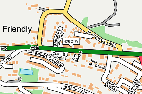
HX6 2TW lies on Spring Gardens in Sowerby Bridge. HX6 2TW is located in the Sowerby Bridge electoral ward, within the metropolitan district of Calderdale and the English Parliamentary constituency of Halifax. The Sub Integrated Care Board (ICB) Location is NHS West Yorkshire ICB - 02T and the police force is West Yorkshire. This postcode has been in use since January 1980.


GetTheData
Source: OS OpenMap – Local (Ordnance Survey)
Source: OS VectorMap District (Ordnance Survey)
Licence: Open Government Licence (requires attribution)
| Easting | 405493 |
| Northing | 424206 |
| Latitude | 53.714244 |
| Longitude | -1.918250 |
GetTheData
Source: Open Postcode Geo
Licence: Open Government Licence
| Street | Spring Gardens |
| Town/City | Sowerby Bridge |
| Country | England |
| Postcode District | HX6 |
➜ See where HX6 is on a map ➜ Where is Halifax? | |
GetTheData
Source: Land Registry Price Paid Data
Licence: Open Government Licence
Elevation or altitude of HX6 2TW as distance above sea level:
| Metres | Feet | |
|---|---|---|
| Elevation | 160m | 525ft |
Elevation is measured from the approximate centre of the postcode, to the nearest point on an OS contour line from OS Terrain 50, which has contour spacing of ten vertical metres.
➜ How high above sea level am I? Find the elevation of your current position using your device's GPS.
GetTheData
Source: Open Postcode Elevation
Licence: Open Government Licence
| Ward | Sowerby Bridge |
| Constituency | Halifax |
GetTheData
Source: ONS Postcode Database
Licence: Open Government Licence
| White Horse Ph (Burnley Road) | Friendly | 24m |
| White Horse Ph (Burnley Road) | Friendly | 27m |
| Burnley Road Timmey Ln (Burnley Road) | Friendly | 178m |
| Burnley Road Timmey Ln (Burnley Road) | Friendly | 225m |
| Burnley Rd Blackwall Lane (Burnley Road) | Friendly | 226m |
| Sowerby Bridge Station | 1km |
| Halifax Station | 4.3km |
| Mytholmroyd Station | 4.5km |
GetTheData
Source: NaPTAN
Licence: Open Government Licence
| Percentage of properties with Next Generation Access | 100.0% |
| Percentage of properties with Superfast Broadband | 100.0% |
| Percentage of properties with Ultrafast Broadband | 0.0% |
| Percentage of properties with Full Fibre Broadband | 0.0% |
Superfast Broadband is between 30Mbps and 300Mbps
Ultrafast Broadband is > 300Mbps
| Median download speed | 39.8Mbps |
| Average download speed | 37.7Mbps |
| Maximum download speed | 78.12Mbps |
| Median upload speed | 10.0Mbps |
| Average upload speed | 9.0Mbps |
| Maximum upload speed | 20.00Mbps |
| Percentage of properties unable to receive 2Mbps | 0.0% |
| Percentage of properties unable to receive 5Mbps | 0.0% |
| Percentage of properties unable to receive 10Mbps | 0.0% |
| Percentage of properties unable to receive 30Mbps | 0.0% |
GetTheData
Source: Ofcom
Licence: Ofcom Terms of Use (requires attribution)
Estimated total energy consumption in HX6 2TW by fuel type, 2015.
| Consumption (kWh) | 204,393 |
|---|---|
| Meter count | 21 |
| Mean (kWh/meter) | 9,733 |
| Median (kWh/meter) | 8,675 |
| Consumption (kWh) | 49,827 |
|---|---|
| Meter count | 22 |
| Mean (kWh/meter) | 2,265 |
| Median (kWh/meter) | 2,274 |
GetTheData
Source: Postcode level gas estimates: 2015 (experimental)
Source: Postcode level electricity estimates: 2015 (experimental)
Licence: Open Government Licence
GetTheData
Source: ONS Postcode Database
Licence: Open Government Licence


➜ Get more ratings from the Food Standards Agency
GetTheData
Source: Food Standards Agency
Licence: FSA terms & conditions
| Last Collection | |||
|---|---|---|---|
| Location | Mon-Fri | Sat | Distance |
| Sowerby Bridge P.o. Box | 17:30 | 12:30 | 886m |
| Station Road | 17:30 | 11:45 | 903m |
| 60 West Street | 17:30 | 11:45 | 922m |
GetTheData
Source: Dracos
Licence: Creative Commons Attribution-ShareAlike
The below table lists the International Territorial Level (ITL) codes (formerly Nomenclature of Territorial Units for Statistics (NUTS) codes) and Local Administrative Units (LAU) codes for HX6 2TW:
| ITL 1 Code | Name |
|---|---|
| TLE | Yorkshire and The Humber |
| ITL 2 Code | Name |
| TLE4 | West Yorkshire |
| ITL 3 Code | Name |
| TLE44 | Calderdale and Kirklees |
| LAU 1 Code | Name |
| E08000033 | Calderdale |
GetTheData
Source: ONS Postcode Directory
Licence: Open Government Licence
The below table lists the Census Output Area (OA), Lower Layer Super Output Area (LSOA), and Middle Layer Super Output Area (MSOA) for HX6 2TW:
| Code | Name | |
|---|---|---|
| OA | E00055041 | |
| LSOA | E01010922 | Calderdale 020A |
| MSOA | E02002263 | Calderdale 020 |
GetTheData
Source: ONS Postcode Directory
Licence: Open Government Licence
| HX6 2TT | Bankfield Terrace | 51m |
| HX6 2TS | Cliffe Terrace | 63m |
| HX6 2UJ | Blackwall Rise | 64m |
| HX6 2TR | Daisy Mount | 65m |
| HX6 2TY | Friendly Avenue | 67m |
| HX6 2TU | Spring Bank | 95m |
| HX6 2TP | The Banks | 101m |
| HX6 2UB | Blackwall Lane | 107m |
| HX6 2RR | Hollins Bungalows | 118m |
| HX6 2TZ | Blackwall | 135m |
GetTheData
Source: Open Postcode Geo; Land Registry Price Paid Data
Licence: Open Government Licence