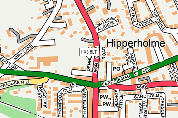
HX3 8LT is located in the Hipperholme and Lightcliffe electoral ward, within the metropolitan district of Calderdale and the English Parliamentary constituency of Calder Valley. The Sub Integrated Care Board (ICB) Location is NHS West Yorkshire ICB - 02T and the police force is West Yorkshire. This postcode has been in use since June 2000.


GetTheData
Source: OS OpenMap – Local (Ordnance Survey)
Source: OS VectorMap District (Ordnance Survey)
Licence: Open Government Licence (requires attribution)
| Easting | 412439 |
| Northing | 425552 |
| Latitude | 53.726224 |
| Longitude | -1.812954 |
GetTheData
Source: Open Postcode Geo
Licence: Open Government Licence
| Country | England |
| Postcode District | HX3 |
➜ See where HX3 is on a map ➜ Where is Brighouse? | |
GetTheData
Source: Land Registry Price Paid Data
Licence: Open Government Licence
Elevation or altitude of HX3 8LT as distance above sea level:
| Metres | Feet | |
|---|---|---|
| Elevation | 160m | 525ft |
Elevation is measured from the approximate centre of the postcode, to the nearest point on an OS contour line from OS Terrain 50, which has contour spacing of ten vertical metres.
➜ How high above sea level am I? Find the elevation of your current position using your device's GPS.
GetTheData
Source: Open Postcode Elevation
Licence: Open Government Licence
| Ward | Hipperholme And Lightcliffe |
| Constituency | Calder Valley |
GetTheData
Source: ONS Postcode Database
Licence: Open Government Licence
| Denholme Gate Rd Allotments (Denholme Gate Road) | Hipperholme | 21m |
| Denholme Gate Rd Allotments (Denholme Gate Road) | Hipperholme | 47m |
| Halifax Road Tanhouse Hill (Halifax Road) | Hipperholme | 101m |
| Halifax Road Tanhouse Hill (Halifax Road) | Hipperholme | 112m |
| Brighouse Road Wakefield Rd (Brighouse Road) | Hipperholme | 134m |
| Halifax Station | 2.7km |
| Brighouse Station | 3.8km |
| Low Moor Station | 4.7km |
GetTheData
Source: NaPTAN
Licence: Open Government Licence
GetTheData
Source: ONS Postcode Database
Licence: Open Government Licence


➜ Get more ratings from the Food Standards Agency
GetTheData
Source: Food Standards Agency
Licence: FSA terms & conditions
| Last Collection | |||
|---|---|---|---|
| Location | Mon-Fri | Sat | Distance |
| Southedge Close Hipperholme | 17:30 | 12:00 | 332m |
| 22 Bramley View | 17:00 | 11:45 | 848m |
| Northowram P.o. Box | 17:00 | 12:00 | 1,852m |
GetTheData
Source: Dracos
Licence: Creative Commons Attribution-ShareAlike
The below table lists the International Territorial Level (ITL) codes (formerly Nomenclature of Territorial Units for Statistics (NUTS) codes) and Local Administrative Units (LAU) codes for HX3 8LT:
| ITL 1 Code | Name |
|---|---|
| TLE | Yorkshire and The Humber |
| ITL 2 Code | Name |
| TLE4 | West Yorkshire |
| ITL 3 Code | Name |
| TLE44 | Calderdale and Kirklees |
| LAU 1 Code | Name |
| E08000033 | Calderdale |
GetTheData
Source: ONS Postcode Directory
Licence: Open Government Licence
The below table lists the Census Output Area (OA), Lower Layer Super Output Area (LSOA), and Middle Layer Super Output Area (MSOA) for HX3 8LT:
| Code | Name | |
|---|---|---|
| OA | E00054980 | |
| LSOA | E01010909 | Calderdale 011D |
| MSOA | E02002254 | Calderdale 011 |
GetTheData
Source: ONS Postcode Directory
Licence: Open Government Licence
| HX3 8EP | North View | 57m |
| HX3 8EW | Halifax Road | 68m |
| HX3 8NB | Whitehall Street | 82m |
| HX3 8HY | West View | 83m |
| HX3 8HX | Denholme Gate Road | 87m |
| HX3 8NY | Inglewood Court | 92m |
| HX3 8DS | Linden Terrace | 114m |
| HX3 8ND | Leeds Road | 117m |
| HX3 8DU | Trinity Place | 130m |
| HX3 8NZ | Hawthorn Street | 135m |
GetTheData
Source: Open Postcode Geo; Land Registry Price Paid Data
Licence: Open Government Licence