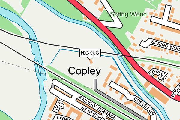
HX3 0UG is located in the Skircoat electoral ward, within the metropolitan district of Calderdale and the English Parliamentary constituency of Halifax. The Sub Integrated Care Board (ICB) Location is NHS West Yorkshire ICB - 02T and the police force is West Yorkshire. This postcode has been in use since January 1980.


GetTheData
Source: OS OpenMap – Local (Ordnance Survey)
Source: OS VectorMap District (Ordnance Survey)
Licence: Open Government Licence (requires attribution)
| Easting | 408346 |
| Northing | 422725 |
| Latitude | 53.700910 |
| Longitude | -1.875063 |
GetTheData
Source: Open Postcode Geo
Licence: Open Government Licence
| Country | England |
| Postcode District | HX3 |
➜ See where HX3 is on a map ➜ Where is Halifax? | |
GetTheData
Source: Land Registry Price Paid Data
Licence: Open Government Licence
Elevation or altitude of HX3 0UG as distance above sea level:
| Metres | Feet | |
|---|---|---|
| Elevation | 70m | 230ft |
Elevation is measured from the approximate centre of the postcode, to the nearest point on an OS contour line from OS Terrain 50, which has contour spacing of ten vertical metres.
➜ How high above sea level am I? Find the elevation of your current position using your device's GPS.
GetTheData
Source: Open Postcode Elevation
Licence: Open Government Licence
| Ward | Skircoat |
| Constituency | Halifax |
GetTheData
Source: ONS Postcode Database
Licence: Open Government Licence
| Wakefield Rd Spring Wood (Wakefield Road) | Copley | 117m |
| Wakefield Rd Spring Wood (Wakefield Road) | Copley | 156m |
| Wakefield Rd Copley Grove (Wakefield Road) | Copley | 199m |
| Wakefield Rd Copley Grove (Wakefield Road) | Copley | 256m |
| Bus Terminus (Copley Lane) | Copley | 299m |
| Sowerby Bridge Station | 2.2km |
| Halifax Station | 2.6km |
GetTheData
Source: NaPTAN
Licence: Open Government Licence
GetTheData
Source: ONS Postcode Database
Licence: Open Government Licence


➜ Get more ratings from the Food Standards Agency
GetTheData
Source: Food Standards Agency
Licence: FSA terms & conditions
| Last Collection | |||
|---|---|---|---|
| Location | Mon-Fri | Sat | Distance |
| 2 St Stephen's Street Copley | 17:15 | 11:45 | 304m |
| Copley | 17:30 | 11:45 | 434m |
| Skircoat Green P.o. Box | 17:30 | 11:45 | 817m |
GetTheData
Source: Dracos
Licence: Creative Commons Attribution-ShareAlike
| Risk of HX3 0UG flooding from rivers and sea | High |
| ➜ HX3 0UG flood map | |
GetTheData
Source: Open Flood Risk by Postcode
Licence: Open Government Licence
The below table lists the International Territorial Level (ITL) codes (formerly Nomenclature of Territorial Units for Statistics (NUTS) codes) and Local Administrative Units (LAU) codes for HX3 0UG:
| ITL 1 Code | Name |
|---|---|
| TLE | Yorkshire and The Humber |
| ITL 2 Code | Name |
| TLE4 | West Yorkshire |
| ITL 3 Code | Name |
| TLE44 | Calderdale and Kirklees |
| LAU 1 Code | Name |
| E08000033 | Calderdale |
GetTheData
Source: ONS Postcode Directory
Licence: Open Government Licence
The below table lists the Census Output Area (OA), Lower Layer Super Output Area (LSOA), and Middle Layer Super Output Area (MSOA) for HX3 0UG:
| Code | Name | |
|---|---|---|
| OA | E00055283 | |
| LSOA | E01010973 | Calderdale 021D |
| MSOA | E02002264 | Calderdale 021 |
GetTheData
Source: ONS Postcode Directory
Licence: Open Government Licence
| HX3 0UH | St Stephens Street | 148m |
| HX3 0US | Copley Drive | 158m |
| HX3 0UR | Wakefield Road | 163m |
| HX3 0UJ | Railway Terrace | 164m |
| HX3 0UX | Dean Court | 189m |
| HX3 0UA | Wakefield Road | 238m |
| HX3 0TZ | Copley Grove | 247m |
| HX3 0UE | Lydbrook Park | 248m |
| HX3 0UQ | Calder Terrace | 254m |
| HX3 0TX | Copley View | 272m |
GetTheData
Source: Open Postcode Geo; Land Registry Price Paid Data
Licence: Open Government Licence